Showing posts with label Log Meadow. Show all posts

Wednesday, August 6, 2025

August 6, 2025 - Park Ridge Lookout


Title: August 6, 2025 - Park Ridge Lookout


Hike Info:
Type:Lookout
 
Description:

It has been over a month since I have been in a Lookout. Of course, I have been somewhat busy with our Ireland trip. Also last week I was sick last week and probably if I was still sick this week, it would have been a good reason to stay home. But fortunately by Sunday I started to feel better.

Tuesday was the day which I got asked to do things lookout related. First Greg called me and asked me to identify the plug which the stove used. I like talking with him. In some ways it is like talking to myself-I think there are similar thought patterns.We also discussed one of the places which we use to orient the Osborne Firefinder. In particular, it is Burnt Point. We use eight orientation points or lantmarks at each lookout to make sure the FireFinder is oriented correctly. There was some question about what the correct azimuth is for this landmark. Also Wendy called and asked if she could meet me to take up some brochures.

Since this is an up and back, I can fit everything into a daypack, except for water. I get a good night's sleep and wake up at 0500. There is no lightning to report, so that is pretty quick. After eating breakfast, I am ready to go by 0630. I pull my food from the refrig, load the car and am off at 0700. I get to the Hume Lake Ranger District office a few minutes before 00800. Wendy is waiting for me. We talk for about 15 minutes-Wendy is the reason why Sherri and I are fire lookouts. We have only enjoyed the relationship more and more. She has some brochures for me to take up.


I stop at the
Big Stump bathroom and then drive up to the Park Ridge Lookout. I get there a few minutes before 0900, plenty of time. It only takes a few minutes to unload the car. It is even faster than I thought it would be. The reason why it is quicker than I thought? I forgot my backpack. The thing which I will miss most is the food for the day. There are a few other things in there, but not essential. I should survive-living off of my body fat.

I get myself set up. One of the first things I do is to take the weather-all seems pretty good. Coming up from the Valley, it seemed like there was a layer of smoke-not sure what fire the smoke is from. But up near at 7,500’, I have pretty decent visibility. I go into service at 0930 with bother Porterville and Ash Mountain Fire.

I start on my first task-trying to figure out the plug. I pull out the stove, not as far as I would have liked. So I can only easily pull the plug out a fraction of an inch. I send a picture to Greg and shortly afterwards he indicates that he really does need to see the male end of the plug. So I reach over the counter and wiggle in and use my finger tips to wiggle the plug out. I did have a thought to use a screwdriver to wedge it out, but then after half a second, I thought how bad of an idea that was. Eventually I got the plug out, took a picture, sent it to Greg. He is happy. So the plug gets plugged in, the stove gets put back into its place, and it even works. 


The second part of my task was to come up with what the azimuth was for Burnt Point. I take my view carefully and compare it to our visual book. The visual book has pictures of everything we can see from the lookout and the azimuth for it. I was within two minutes of the visual book value. That is close. I also have a spreadsheet with the computed azimuth from the lat/long of two points. With this one I was within one minute.

Visual

169o30’

Firefinder

169o32’

Computed

169o33’

This gets me to about 1030. The rest of the day is spent doing lookout things. Such as scanning, listening to the radio, and a bit of daydreaming. If you have looked at my Burnt Point page, you will notice that there is a picture of the landmark. I took some pictures of places which I do not have pictures of them before. We shall see how usable they are.

With no lunch, I ignore any rumblings coming from my stomach for the afternoon. It is one of those afternoons which lookouts both are happy with because there is no relevant activity. But it does make the time go past slowly. Around 1730, I got ready to vacate the lookout. And at 1750, I went out of service.

After I text Sherri with my plans to eat on the way down at Bear Mountain Pizza, I start off. At Log Meadow, there is a flock of bovine-I know, cattle do not come in flocks. When I get cell reception, I let Wendy know so she can tell whoever is coming in tomorrow to be on the alert for these beasts. When I get to Big Stump I put in my order and tell them that I would eat in. I got behind a slow car, but that is OK. I get to Bear Mountain Pizza a few minutes after 1900. Apparently they were closing in-restaurant dining when I came in because the guy did not seem to be happy that I was eating in. They turned the sign to close after I got my order. So I eat fast and did not doddle. I get home a little have 2000, a bit tired, but glad I went up.


Trail LessonNo matter how much you take care to pack everything, chances are that you will forget something. Deal with it and move on.


Wednesday, November 1, 2023

November 1, 2023 - Crescent and Other Meadows


Title: November 1, 2023 - Crescent and Other Meadows
Hike Info : Description : T  Extra Photo's : Flowers and Plants


Hike Info:

Type: Hiking

Trail head: Crescent Meadows Parking Area

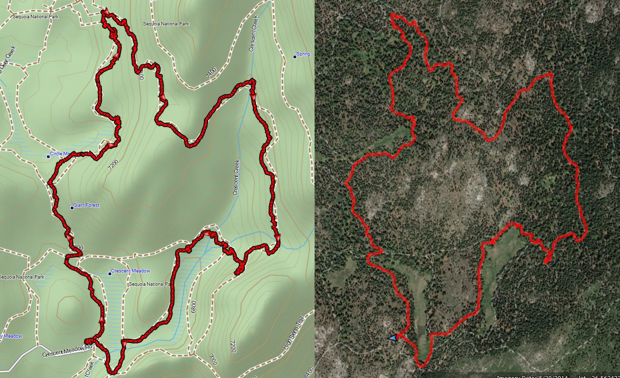
Trail: Crescent Meadow, Circle Meadow,  Trail of the Sequoias, Log Meadow

Destination:  Wander

Distance:  5.95 miles 

Start Time:  11:05

End Time:      3:43

Travel Time:  4:38 (1.28 mph)

Moving Time:   3:43 (1.60 mph)

Elevation Rise:  1,173'

Descent: 1,194‘

Maximum Elevation: 7,344'

GPS Tracks


Sherri on path

Description:

It has been a couple weeks since we went hiking. Also about this time the broadleaf trees should be turning into more autumn coloring. It will be just Sherri and I. Also, it is the first day not doing a lightning report for the fire lookout-we went out of service Monday.

But I still get up before 7. Sherri gets up about half an hour later. We left our house at 8:45 with me driving. Once we get to the foothills, we see smoke and it is getting pretty dense towards the Redwood Mountain area which means it could be either or both the Big Stump prescribed burn or from the Rabbitt Fire. When we got up to the Park's entrance there are signs saying don't report the smoke as these are known fires already. We definitely do not have the car windows rolled down. When we drive by the Buena Vista area, we see small columns of smoke rising from blacked stumps and branches. But as we moved towards Giant Forest, away from the fires, the smoke decreased.

Sequoia at end of Circle Mdw
We talked about doing a loop we have done a couple of times. But the KNP Complex fire a couple of years ago did a number to parts of the trail. So we parked at Crescent Meadow Parking Area at 10:50. Even though it is not smokey, maybe a bit hazy, here, there is a slight acidic smell which I identify as smoke.


At 11:10, our boots hit the dust. Usually we have gone somewhat counter-clockwise. Today we start off the same way the clock does. We head along Crescent Meadow. The meadow is in its seasonal decline. Most of the grasses and ferns have faded to a yellow. But then the Sequoias which ring the meadow just show that much more.

We bump over a low ridge and come into Circle Meadow. We take the trail to the east of it. The trail goes up and down to avoid trampling on the meadow. The meadow is in the same seasonal status as Crescent. But this one is a bit longer, so we look down the length of the meadow, seeing Sequoias showing off.

There are two things which cause us to pause. The first thing we have seen is the burnt remains of a Sequoia. This gets me to wondering how this tree caught fire and burnt so badly. The tree seemed so isolated as there were no other seriously burnt trees close by. It takes a lot to burn a Sequoia. Later on there was a large area where there were many more burnt trees. I think this area was a large and maybe intense spot fire from the KNP Complex.


Chief Sequoyah Tree
The second thing is the number of freshly fallen trees. These are monster size Sequoias, looking like they have fallen within the last six months to a year. Some of them still had greenery on them. I started wondering if a Giant Sequoia fell and if nobody was around, would it still measure on a seismograph? (By the way, the answer is yes.) The thought I really had is if these giants could topple over after standing centuries or a millennium or two, what chance do I have for standing up against time and the elements?

Just before we hit the Congress Group, we stop and have lunch. There was a nice tree to sit on and it was pleasant enough in the area. Before taking off again, I shed the pants legs and hike the rest of the day in shorts and a T-shirt. Not bad for the first day of November.

When we get to The Senate Group, we branch off onto The Trail of the Sequoias. The Chief Sequoyah Tree starts us off. While not the most awesome tree in the forest, it is a tree of significance. Chief Sequoyah is who brought a written language to the Cherokee and was subsequently adopted by other Indian nations. He is also who the Sequoia trees are named after.


The Trail of the Sequoias now ascends up the ridge above the Congress Grove. When we get to the top of the rise, we come across a whole area-several acres-which were burnt during the KNP Complex. It does not feel like this was the main part of the fire, but maybe a spot fire? We met a guy from Los Angeles. He did not think this was a spot fire. Later on looking at some of the fire maps, I think my guess of this being a spot fire is correct.

Gary wandering the paths
Still the area looks so different than the last time we were here. Not only coming up from a different direction, but the extent of the burn. There is a majestic tree right at the top. It had been previously burnt, but now it looks so much more black today. After ten minutes of walking, we leave the burnt area and continue on the Trail

We debated about going on the Eagle View or drop down to Log Meadow and Tharp's Cabin. We decided that we have walked enough for now. So we dropped into Log Meadow. As we descend, we see some color we have been looking for come into view. It looks even more impressive when the background is a giant Sequoia which fell a long time ago.


A short walk away is the cabin where Tharp Summered in the area. I am always impressed with how short Tharp must have been. Now we are less than a mile away-even though the sign says 0.08 miles-it is more. But the walk is pleasant as the sun still provides some warmth for us weary travelers.

When we get back to the car, I see that SEKI Fire is here, particularly BC-3. I met him a couple of months ago as I was going into Park Ridge and he was coming out. He was over at Eagle View to observe the Redwood Fire-it is still going, sending up columns of smoke, but not really much volume.


 We take off for Fresno about 4:00. We both are a bit hungry, so we stop in Yokut or Squaw Valley at Bear Mountain Pizza. The pizza was better than the last time we were here. On the way back to Fresno, we join the family Zoom call-a good way to end the day.


Extra Photo's
Giant Sequoia

Burnt remains

Freshly fallen giant

Tree at the end of Circle Meadow


Castle Rocks across the Kaweah from us

Gary on the trail

Another burnt tree

Sherri, Gary and the Chief Sequoyah Tree

Chief Sequoyah Tree

Sherri


Creek into Log Meadow

Gary at Log Meadow

Giant fallen long ago at Log Meadow

Log Meadow

Gary walking through a Giant Sequoia


Flowers and Plants


Wednesday, May 30, 2018

May 30, 2018 - SEKI Hikes


Title: May 30, 2018 - SEKI Hikes
Hospital Rock: Hike Info : Description 

Moro Rock: Hike Info : Description
Eagle View:Hike Info : Description 
Tokopah Falls: Hike Info : Description 
Big Stump: Hike Info : Description
 Trail Lessons : Background : Flowers and Plants
This was a series of five events-some are too short to really be called a hike-organized by John and Cathey of the meetup group, Central Valley Hiking Group. The idea was to give a sampler along the General’s Highway corridor in Kings Canyon and Sequoia National Parks.We started down by Ash Mountain in the southern part of Sequoia, near Three Rivers and ended up at Bear Mountain Pizza in Squaw Valley for dinner. A very full day.
Grinding Holes

Hike Info:
Type: Hiking
Trail: Walked
Destination: Petroglyphs
Distance: 50 yards-No GPS


Description:
Pictrographs
We got out of the car at the Hospital Rock parking lot and went across the highway. There are a couple of grinding holes close by. Then the pictographs are behind some boulders. My thinking is there must have been some tall Native Americans back in those days. The pictographs are a smeared, but you can make out some of them. The yucca plants and buckeye are in bloom. We followed a social trail up a little ways where we came out onto the highway again with a view of Moro Rock. Back to the cars and off we go. 

View of Moro Rock from Hospital Rock

Unknown to us, there were more pictographs than what we saw.


=============================


Looking east to the Kern-Kaweah Divide
Trail head: Moro Rock parking area
Hike Info:
Type: Hiking
Trail: Moro Rock
Destination: Moro Rock
Actual Destination:
Distance:  0.6 miles No GPS


Sherri climbing up Moro Rock
Description:
The walk itself is not for those who are concerned with heights. The trail immediately rises up the side of Moro Rock, ascending through a series of pathways, stairs, and cracks in the rock as you interweave between the east and west sides of the rock. I take plenty of breaks to gather in the sights, as well a bit of oxygen. On this trail, it is worth doing that since you rise up about a hundred feet per tenth of a mile to a total of 300’. Please admiring the different views of both the Kern-Kaweah Divide and the Central Valley are some of the enjoyable parts of doing this walk.


More of the Kern-Kaweah Divide
From the top, the view is incredible!. It is a mostly clear day-at least the haze has not set in with full force. There are clouds over the Kern-Kaweah, but they just add to the beauty. This is a 360 degree view, from Little Baldy and Mt Sillman in the north to Sawtooth and Castle Rocks in the south; from Alta Peak and the whole slew of Kaweah peaks in the east to Lake Kaweah in the west. Just a good view. Not as crowded as it could be. But it is time to get off the Rock and on to the next hike.


==============

Trail head: Crescent Meadows
Hike Info:
Type: HikingTrail:
Destination: Eagle’s View
Actual Destination: Eagle’s View and Tharp’s Log
Distance:  2.64 miles  1
Elevation Rise:  660'
Descent: 660‘
Maximum Elevation: 6,913'
GPS Tracks-From Google Earth rather than GPS
Group at Eagle's View
 1From Google Earth-did not turn on GPS.
Description:
I should have thought and turned on my GPS, knowing this would be a two mile round trip. Since I have taken people here before, John has asked me to lead the way. Not a problem. We circle around the south end of Crescent Meadow after admiring the High Sierra Trail sign and wondering how far should we hike today? 60 miles gets us to Mt Whitney and another 11 miles gets us down to Whitney Portal. Nobody, particularly me, are up to it. So off we go to Eagle View.
Returning from eagle's View
Eagle View is an easy walk along the High Sierra Trail, about half an hour. We climb a ridge. But before we get all the way up, we come across a family whose child has skinned a knee. Being the good former Boy Scout, I offer a band-aid. I dig to get to me First-Aid kit and find that unlike a good Boy Scout, I do not have any band-aids. But Sherri discovers a butterfly band-aid and that satisfies the wounded boy. And off we go.
We go up to the top of the ridge where John asks about where the other trails go to-Trail of the Sequoia’s and Tharp’s Log. And then we are off to Eagle’s View. This view gives an expanded view of the Kern-Kaweah Divide without the crowds Moro Rock provides. Our group enjoys it enough to have another group picture. Then John says lets go over to Tharp’s Log instead of returning back how we came.
Tharp's Log
Log Meadow
So off we go again, back to the junction and we head towards Log Meadow, only a tenth or two of a mile away. Then around the meadow we go. I should say here, as I have often said, we become inured to the beauty around us by the familiarity of seeing something so often. So it can be a real joy to having a person along who is experiencing a mountain trail, a Sequoia Gigantea, a mountain meadow, and a granite dome for the first time. So wonderful to have Patty’s fresh eyes on scenes which I have become accustomed to!
After we reach the end of Log Meadow, we come to Tharp’s Log. Pretty much like we have seen it before. We all are getting a bit hungry, so we do not stop very long here. From this point back to the parking lot, the path is paved. When we get back to the cars, we take off to Lodgepole for a bite to eat.

==============


Hike Info:
Type: Hiking
Trail: Tokopah Falls Trail
Destination: Tokopah Falls
Distance:  4.27 miles
Start Time: 2:43
End Time:  5:12
Travel Time: 2:29  (1.72 mph)
Moving Time: 2:04  (2.07 mph)
Elevation Rise:  726'
Descent: 562‘
Maximum Elevation: 7,319'
Description:
After eating at Lodgepole, we pack into the cars for a short drive into the campground. This getting in and out of the cars has been a bit wearing. Sherri and Lee decide to stay with the vehicles and take a nap for this hike.The rest of us take off for the 2+ miles to Tokopah Falls.
Tokopah Falls
The trail starts inside of the Lodgepole Campground, just across the bridge over the Marble Fork of the Kaweah River. It is flowing pretty good. The trail goes up the north side of the River and climbs pretty steadily. It is a busy trail, but not as busy as it will be later on in the summer. We go through a lodgepole pine forest where a combination of grasses, berries and trees grow among the granite. I am towards the last. Not really tired-the legs, not the lungs for a change, are the most affected. Still I am hiking well. Patty and Catherine are before me. We catch glimpses of John, Cathey and Oz in front of us.
Tokopah Falls


At one point I stop and talk with a couple which I found out are naturalists for the Sequoia Conservancy. They are on their day off exploring. We trade information for about five minutes and then are off. By now the rest of the group is waiting for me.
Tokopah Falls
So off we go again and in about ¾ of a mile we get to Tokopah Falls. I think it is running fuller than I have seen it before. This can be a really beautiful set of falls going from the top to the bottom. All of us want our pictures taken here.
Time to go back and I draw the rear guard station-or more diplomatically called the Sweep. Coming in last means that I get to take lots of pictures of what every comes into my eyesight. Which very often I do not do justice to them.
I catch up to John eventually and we talk on the way down. John is thinking we need to hurry before it gets dark. But I say that we still have a couple of hours until it gets dark. So we continue to wander down the path in an unhurried fashion.
Marble Fork of the Kaweah River
When we get back to the cars, John announces we will stop for our final stop at the Big Stump Parking Lot. Ahhh, do we haft to? We are tired! Whine, whine, whine.

================

Hike Info:
Type: Hiking
Trail: Big Stump Meadow
Destination: Mark Twain Stump
Distance:  1.23 miles
Start Time: 6:02
End Time:   6:48 
Travel Time:  0:45 (164 mph)
Moving Time: 0:39  (1.89 mph)
Elevation Rise:  326'
Descent: 290‘
Maximum Elevation: 6,436'

Description:
Big Stump Meadow


It is around 6pm, a bit late for a hike, but it is short and John is truly excited to show us the Mark Twain Stump. But we are told it is only a short ways. So all of us take off down the trail. The operative word is done. Not a lot, but this is the end of the day and we have been in and out of cars a lot. So we get down to the Meadow, we cross the Fallen Giant. log-a huge log which splintered upon impact. Then it rounds around several stumps. As we walk this area, I think of snowshoeing this a  year and a half ago with Betty and Rose. What a difference a layer of snow makes in appearance.
I call this a castle stump
Then we get to the Mark Twain Stump. It is a huge stump and we all climb up the stairs and get on top of the stump with ample room to spare. You can tell from the excitement on John’s face that he really wanted to share the history of this stump, so I am glad we did it. It is a day of sharing wonders and excitement from those younger than I to those older. What at great world we live in where there is so much to share and enjoy.
After the mandatory photo-op, we have our return trip back to the cars. Nothing fancy, just a short mile and a quarter walk. On the way back to Fresno, we order pizza’s from Bear Mountain Pizza. Then back home by 8:30pm.


Trail Lesson:
Just because I am tired does not mean that we should not walk a trail to share someone else’s excitement.


Background
Pictographs vs petroglyphs: pictographs are painted on the rock, whereas petroglyphs are carved into the rock. From the Last Adventurer blog
Hospital Rock. Evidently there is many more pictographs in the area than what we saw. Michael Fuller has a web page which shows these pictographs in more detail.
Mark Twain Stump. This was a 1,350 year old tree which was felled in 1891. It took two mean thirteen days to fall the tree. The purpose? To display its slabs from its 16’ diameter trunk at New York and London museum. From the PBS site on National Parks


Flowers and Plants


Buckeye

Yucca Plant

Sequoia Gigantea

Snow Plant

Dogwood