Showing posts with label Buena Vista. Show all posts

Friday, October 2, 2026

October 2, 2026 - Buena Vista Peak


Title: October 2, 2026 - Buena Vista Peak
Hike Info : Description
: Extra Photo's


Hike Info:

Type: Hiking 

Trail head: Buena Vista Trailhead

Trail: Buena Vista Trail

Destination: Buena Vista Peak

Distance:  2.02 miles

Start Time: 10:37

End Time:   12:56

Travel Time:  2:19 (0.87 mph)

Moving Time:  1:19  (1.53 mph)

Elevation Rise:  532'

Descent: 504‘

Maximum Elevation: 7,639'

Minimum Elevation: 7,611'

GPS Tracks


Description:

Start of trail
This morning did not start off very well. Evidently yesterday while timing some things, I inadvertently set my alarm. So the rooster alarm crowed at 5:45. I apologized to Sherri and I got up. I sort of moseyed around doing things which I had neglected to do for the past couple of days. Rachel came in a little after 8; Steven was up a little before 8; while Sherri got up about 7:40.

By the time we are ready to leave, it is 9:07 on the car’s clock. I am driving. One of the things which we discussed on the way up to the Park is where do we want to go with our Alaska Air companion fare? No definite decision, but I think there was some clarification about desires. We stopped at Big Stump once we passed through the entrance station. We then progressed on to the Buena Vista trailhead, arriving about 10:20.

I can tell that we have not been hiking in awhile. It takes us a while to get ready once we parked, about 20 minutes. We hit the trail about 10:40. There is another clue that I have not been hiking much-The trail starts off going up and I am leading. I immediately go into a deliberate pace. That should be interpreted as being that I was making sure I did not suck air. 


We quickly encountered a fallen tree which we walked around. One thing which we noted is that the tree cover was sparse. In October, this should not be too much of a problem. But today is a warm day and we can feel the mid-day sun bearing down on us. That tree is not the only one down. Another tree there was no going around and it is about 3 to 3½ feet in diameter, a bit of an obstacle. But we all got over it.


Kings Canyon Overlook


We stopped several times on the way up, making sure there was shade when we stopped. But we make steady progress. I had chosen this trail for two reasons. First it is only a mile up. The second is that there is a good, but manageable climb. I think I need this just as much as Sherri. At least I stop as my breathing gets labored and my heart beats hard. All manageable, just an indicator that my body is not what it once was.

When we reach the top of the ridge, we do our final rest break. When we head out, Steven goes on ahead and reaches the top about ten minutes before us. Somehow this segment seemed a bit shorter than what I remember-usually it is the other way around. Rachel, Sherri and mine arrival is 11:35.

Either way, we all get to the top. From here we enjoy the view, as you should do from a peak. From here, we view two of our lookouts: Buck Rock and Park Ridge. Usually Park Ridge is hidden behind trees, but there it is. I am wondering when was the last time we were up here? Was it before the KNP Complex fire? The answer when I got home was June of 2022, a year after the KNP fire.

Looking towards Buck Rock, there is what looks like a trail. I am not familiar with a trail in that area, so I called Jessi at Buck Rock to see if she knows of a trail down there. No, but there are a couple of roads. But it does not look like a road. Later on when I got home and blew up a picture, I could see that it could be a road.


Looking to the west, there are three predominant features:
Redwood Mountain, Redwood Canyon and Big Baldy. That KNP fire devastated the canyon as well as the south side of Redwood Mountain. But surprisingly the upper part of the canyon still has Sequoias standing.

We looked some more, and had an energy bar before we left. The trip down is a lot easier than coming up. On both ways, there is not much in the way of floral. I see a penstemon or two. Also some of the grasses have turned to their Fall colors. We made it back to the car before 1:00.

I drove us back. The question which always comes up after a hike is where to eat? We talked about Bear Mountain Pizza or Habit Burgers in Fresno. Instead of these places,we decided to go Mexican at a place some friends of ours introduced us to: Los Panchos Mexican Restaurant on Kings Canyon. This means delaying eating for an hour, but I guess I will be off to live off of my fat until we get there. The food is good when we get there and we are content after eating. We get home about 3:30, a bit tired,

Extra Photo's
Gary towards the end of the hike

Rachel on the trail

Park Ridge Loookout

Buck Rock Lookout

Some sort of mello plant, I think

Redwood Canyon and Mountain


Thursday, July 3, 2025

July 3, 2025 - Park Ridge Lookout


 Title: July 3, 2025 - Park Ridge Lookout


Hike Info:
Type: Lookout
Description:

It is a busy morning. I woke up at 0515 and started on the lightning report. Lots of stops and starts to it. There were 550+ strikes yesterday in our area. I did a partial report without all of the details. There was just too much with the laptop I have. It has got me wondering, should I get a different laptop? Can I do the report on my tablet? Things to ponder.

 Today will be a long day. I go in-service with both Sequoia National Forest and the Park at 0800. I am the only lookout I heard going into service at this time. Later on Jeff at Buck Rock reports a fire, but I did not hear him going into service. The fire I heard reported is behind Maddox Mountain. But initially I could not place it as I was only given the lat long. But I gradually worked out where it was. The smoke has not risen to where I can see it. It was probably caused by yesterday’s lightning. Division 3 takes charge and orders up a team. They will hike in a couple of miles over Marvin Pass to the fire.

In the meantime, the Big Stump Incident Commander is reporting on the prescribed burn. Even with the wind last night, the lines held and they will mop up. I add I saw some smoke around 1910, but it died down. He indicated that the wind had kicked up some embers, but it died down again. I confirmed that he wanted to know about any smoke there

Park Ridge Greeters

Then it is the normal routine stuff. Scan, listen to the radio, take the weather. Oh wait, I am late in doing the latter. Still not a big issue as things are pretty calm. The Gammon fire is a little interesting, but now that the crews are mobilizing, there is not much radio traffic. That will come this afternoon when the crews have tackled the fire and report back on what they found. When I asked Buck Rock where it is, he said it was a bit south of Shark Rock-I do not know where this is.

At 0931 I took the weather-nothing unusual today. Then at 1000 the weather and staffing is reported by Porterville. I got some company about 1020-a crew from PG&E had come up and was clearing the brush and tree limbs from the power lines.

But that is not my only entertainment. I watch a couple hawks gliding around the air current off towards Buena Vista Peak. Then they swoop down in front of me and disappear for away, only to reappear to do their sky dance.

I must be getting really bored. The lookout at Delilah, it is his first day soloing, so I call over to see how things are going over there. Finally a bit after noon, I got my first visitors. They ask questions and I try to explain the functioning of a lookout, along with the territory they are seeing.

We hear a little more about the Gammon Fire. The crews have made it in and gave a size up on it. It is 50’x50’ with a fire burning in the top of a tree 30-40’ up. They intend to secure the lines around the area and then hike out, starting in 2 to 2.5 hours.

Elwood Fire

Patrol 33 over in the Big Meadows area has her hand full. There is a report of a downed tree across a road. She goes out and clears it. Then found another one. An engine wants to put signs around saying no off-road vehicles-does Patrol 33 have any? None today-she usually has everything in her truck.


Elwood Fire after 30 minutes

I have continued doing my scans. There is a lot of haze, but I see a bit of something unusual around Tivy Mountain. I call over to Delilah and ask if he sees it. He does now. Buck Rock says that CalFire is responding. Delilah will call in a confirmation. SQF personnel start to respond. After about 40 minutes they are called off.

Park Ridge Lookout

The Big Stump burn reports in. I later told him that I had been seeing puffs of smoke all afternoon. Apparently that is not what Ash Mountain wants to be hearing as Wendy calls me up. She got a call and is relying on that they do not want to hear about the smoke on the prescribed burn. 

Evening


A little before 1900 I go out of service with Ash Mountain. But I keep on scanning until 2000 for SQF. Then with Buck Rock, I go out of service.

Today after putting stuff away, there is time to go for a short walk just down the road to the base of the knoll the lookout is on. Then back up to the cab. I talked with Sherri for a little bit. Then back down to the ground. I tried to get some pictures of the stars, but no success. But I did get one of the lookout. By the time my head hits the pillow it is getting close to 2200.


Background

Not really background, but as I am trying to find where the Gammon Fire is, I wonder, can I build a spreadsheet which will compute the lat/long based upon the azimuth and distance from a location? I already go the other way and compute the azimuth and distance from a lookout, based upon the lat/long.


Menu

Breakfast

Lunch

Dinner

Snacks

Granola

Peanut Butter and Nutell along with some sun chips

Quesadilla

Granola, ritz crackers Jelly Belly


Extra Photo's

Park Ridge Lookout at Night

Morning to the east

Sunrise

Sunrise


Wednesday, November 1, 2023

November 1, 2023 - Crescent and Other Meadows


Title: November 1, 2023 - Crescent and Other Meadows
Hike Info : Description : T  Extra Photo's : Flowers and Plants


Hike Info:

Type: Hiking

Trail head: Crescent Meadows Parking Area

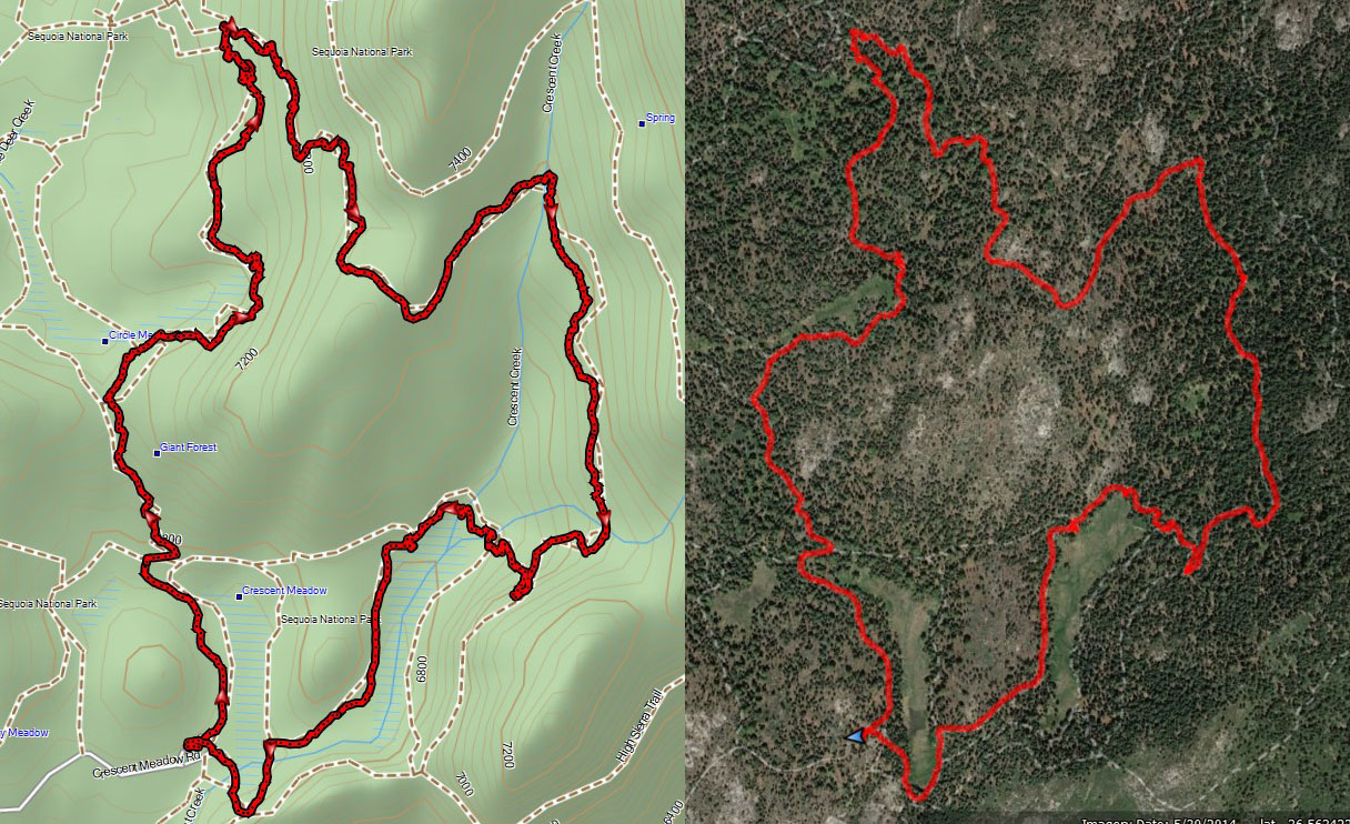
Trail: Crescent Meadow, Circle Meadow,  Trail of the Sequoias, Log Meadow

Destination:  Wander

Distance:  5.95 miles 

Start Time:  11:05

End Time:      3:43

Travel Time:  4:38 (1.28 mph)

Moving Time:   3:43 (1.60 mph)

Elevation Rise:  1,173'

Descent: 1,194‘

Maximum Elevation: 7,344'

GPS Tracks


Sherri on path

Description:

It has been a couple weeks since we went hiking. Also about this time the broadleaf trees should be turning into more autumn coloring. It will be just Sherri and I. Also, it is the first day not doing a lightning report for the fire lookout-we went out of service Monday.

But I still get up before 7. Sherri gets up about half an hour later. We left our house at 8:45 with me driving. Once we get to the foothills, we see smoke and it is getting pretty dense towards the Redwood Mountain area which means it could be either or both the Big Stump prescribed burn or from the Rabbitt Fire. When we got up to the Park's entrance there are signs saying don't report the smoke as these are known fires already. We definitely do not have the car windows rolled down. When we drive by the Buena Vista area, we see small columns of smoke rising from blacked stumps and branches. But as we moved towards Giant Forest, away from the fires, the smoke decreased.

Sequoia at end of Circle Mdw
We talked about doing a loop we have done a couple of times. But the KNP Complex fire a couple of years ago did a number to parts of the trail. So we parked at Crescent Meadow Parking Area at 10:50. Even though it is not smokey, maybe a bit hazy, here, there is a slight acidic smell which I identify as smoke.


At 11:10, our boots hit the dust. Usually we have gone somewhat counter-clockwise. Today we start off the same way the clock does. We head along Crescent Meadow. The meadow is in its seasonal decline. Most of the grasses and ferns have faded to a yellow. But then the Sequoias which ring the meadow just show that much more.

We bump over a low ridge and come into Circle Meadow. We take the trail to the east of it. The trail goes up and down to avoid trampling on the meadow. The meadow is in the same seasonal status as Crescent. But this one is a bit longer, so we look down the length of the meadow, seeing Sequoias showing off.

There are two things which cause us to pause. The first thing we have seen is the burnt remains of a Sequoia. This gets me to wondering how this tree caught fire and burnt so badly. The tree seemed so isolated as there were no other seriously burnt trees close by. It takes a lot to burn a Sequoia. Later on there was a large area where there were many more burnt trees. I think this area was a large and maybe intense spot fire from the KNP Complex.


Chief Sequoyah Tree
The second thing is the number of freshly fallen trees. These are monster size Sequoias, looking like they have fallen within the last six months to a year. Some of them still had greenery on them. I started wondering if a Giant Sequoia fell and if nobody was around, would it still measure on a seismograph? (By the way, the answer is yes.) The thought I really had is if these giants could topple over after standing centuries or a millennium or two, what chance do I have for standing up against time and the elements?

Just before we hit the Congress Group, we stop and have lunch. There was a nice tree to sit on and it was pleasant enough in the area. Before taking off again, I shed the pants legs and hike the rest of the day in shorts and a T-shirt. Not bad for the first day of November.

When we get to The Senate Group, we branch off onto The Trail of the Sequoias. The Chief Sequoyah Tree starts us off. While not the most awesome tree in the forest, it is a tree of significance. Chief Sequoyah is who brought a written language to the Cherokee and was subsequently adopted by other Indian nations. He is also who the Sequoia trees are named after.


The Trail of the Sequoias now ascends up the ridge above the Congress Grove. When we get to the top of the rise, we come across a whole area-several acres-which were burnt during the KNP Complex. It does not feel like this was the main part of the fire, but maybe a spot fire? We met a guy from Los Angeles. He did not think this was a spot fire. Later on looking at some of the fire maps, I think my guess of this being a spot fire is correct.

Gary wandering the paths
Still the area looks so different than the last time we were here. Not only coming up from a different direction, but the extent of the burn. There is a majestic tree right at the top. It had been previously burnt, but now it looks so much more black today. After ten minutes of walking, we leave the burnt area and continue on the Trail

We debated about going on the Eagle View or drop down to Log Meadow and Tharp's Cabin. We decided that we have walked enough for now. So we dropped into Log Meadow. As we descend, we see some color we have been looking for come into view. It looks even more impressive when the background is a giant Sequoia which fell a long time ago.


A short walk away is the cabin where Tharp Summered in the area. I am always impressed with how short Tharp must have been. Now we are less than a mile away-even though the sign says 0.08 miles-it is more. But the walk is pleasant as the sun still provides some warmth for us weary travelers.

When we get back to the car, I see that SEKI Fire is here, particularly BC-3. I met him a couple of months ago as I was going into Park Ridge and he was coming out. He was over at Eagle View to observe the Redwood Fire-it is still going, sending up columns of smoke, but not really much volume.


 We take off for Fresno about 4:00. We both are a bit hungry, so we stop in Yokut or Squaw Valley at Bear Mountain Pizza. The pizza was better than the last time we were here. On the way back to Fresno, we join the family Zoom call-a good way to end the day.


Extra Photo's
Giant Sequoia

Burnt remains

Freshly fallen giant

Tree at the end of Circle Meadow


Castle Rocks across the Kaweah from us

Gary on the trail

Another burnt tree

Sherri, Gary and the Chief Sequoyah Tree

Chief Sequoyah Tree

Sherri


Creek into Log Meadow

Gary at Log Meadow

Giant fallen long ago at Log Meadow

Log Meadow

Gary walking through a Giant Sequoia


Flowers and Plants