Showing posts with label Winchell. Show all posts

Wednesday, February 11, 2026

February 5, 2026 - Blue Oak Trail


Title: February 5, 2026 - Blue Oak Trail


Hike Info:

Type: Hiking

Trail head: Blue Oak Picnic Area

Trail: Blue Oak Trail

Destination: Closed trail in Winchell Cove

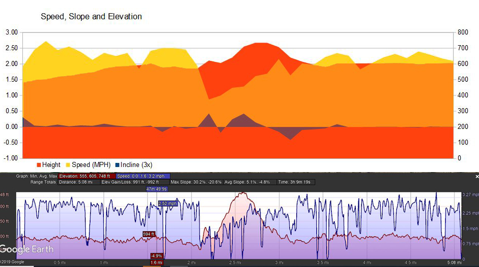
Distance:  5.78 miles

Start Time: 1:53

End Time:   5:06

Travel Time: 3:12  (1.81 mph)

Moving Time:  2:35  (2.24 mph)

Elevation Rise:  616'

Descent: 548‘

Maximum Elevation: 606'

GPS Tracks


Description:

Today we were to go back up to Badger Pass. But yesterday in the morning it was quite foggy. Also I really lacked a lot of energy. So I called off that activity and said lets see what Thursday brings. If things look good, we can do a hike at Millerton. Today there was hardly any fog and I had at least some energy. So it will be off to Millerton after lunch.

Mystery Boat
Rachel comes over about 11 and continues her work on a puzzle we got at Christmas time of Horseshoe Bend. It is driving us nuts. I have my lunch at noon and have a brief siesta and am ready to go at 1pm. We actually leave about 1:10 with me driving to Millerton. There is some confusion about where the Blue Oak Trail is-not by me. It is on the south side of the lake. We get to the picnic area and park there instead of at the end of the road. This will give us about three more miles of walking. We parked about 1:40 and were ready to hike at 1:50. Before we started, I shed my long sleeve shirt and take off my pants legs. Even though it is February, it is that warm of a day.


The trail from the picnic grounds to the end of the road is not all that interesting. On the west side of the trail, there is the road; the east side has a fence which is the border of the State Recreation Area. Beyond the fence are houses with barking dogs and overlooks of the lake. The trail goes over a series of low ridges and shallow ravines.

I feel like I am walking pretty well. I am in the lead with Rachel following me. Sherri and Steven follow at various lengths behind. We make pretty good time, probably walking around 2½ mph. There are some wildflowers along the way-Blue Dicks, Skunk Monkeyflowers and Popcorn flowers is what I think we mostly encountered.

A little past the end of the road is a bench. It gives a nice view of the lake and we stopped there for about 15 minutes just to gaze onto the lake-and if the truth be known, also to give my lungs a respite. 


A little ways further we spot something moving in what appears to be a haphazard way in the lake. There does not appear to be anybody and to the naked eye it is a strange shape for a boat. Out comes some binoculars and I get my phone’s camera to a good magnification. It is a boat with a couple of fishing poles out the rear, a sonar in front and a guy dressed in light blue almost motionless sitting in the middle. Mystery solved! It can be interesting to speculate, then a bit relieving to come up with something definite.

Then it is off again. Rachel and I talk about various subjects. Like last week, it is one of the pleasures of walking with my children. They have all reached the age where they have a certain maturity of thought. This makes it fun and many times enlightening hearing from them.

I had set a 3:30 turn around time. If we had not reached the end of the trail, we would turn around anyway. I wish I could say it was because of superior planning, but we reached the part of the trail which has been closed for about a year now right at 3:30. We enjoy the view here as well. Like when Sherri and I were here in December, the trail is still closed because the trail is endangered of being eroded away.

We are hoping to get back to the car at 5 before the sun goes down. Off we go. We had seen a building a bit beyond the docks at the entrance to Winchell Cove. I am speculating that it is an outhouse-later on when I look at the pictures, I am thinking it is something else. The mountains which we are seeing beyond it, which should be covered with snow, presents a nice backdrop to the still waters of the lake.


Steven is taking the lead, while not far ahead during much of the walk back, Sherri is ahead of Rachel and myself-not sure Sherri wanted that honor, particularly when she stops to take some pictures. I think Rachel just wants to make sure her father does not do anything stupid, so she makes sure she is the sweep.


The skies are darkening as the clock closes in on 5. It is not dark yet. The diminished light gives both an interesting fullness in the pictures. I do stop mostly to take pictures of flowers and scenery, but this also gives me the opportunity to take a few breaths before starting out again.

We catch up with Sherri about half a mile before the car. It has been awhile since I have walked this far. It is good to know that I came in tired but strong. We arrive at the car a little after five to find Steven waiting for us. I drove us back home. There we take a shower while Rachel goes on a training run for half an hour-to be young and have that energy. I do not think I ever had that kind of desire to run after walking close to six miles. When Rachel comes back, she takes us to a Mediterranean restaurant called Mayd. Not bad-I had a chicken sandwich. When we got back, Rachel and Steven worked on a puzzle while I gave them moral support until I went to bed.


Extra Photo's


Specks of green on a rock

Father daughter hiking

Interesting hill

Steven, Gary, and Rachel at trail's end

Mystery boat

Animals


Hawk in flight


Flowers and Plants

Iris

Iris

Blue Dick

Blue Dick

Blue Dick

Blue Dick

Miner's Lettuce

Miner's Lettuce

Popcorn Flower


Skunk Monkeyflower

Skunk Monkeyflower

Skunk Monkeyflower


Wednesday, January 15, 2020

January 15, 2020 - South Shore Trail


Title: January 15, 2020 - South Shore Trail
Hike Info : DescriptionExtra Photo's : Animals
Hike Info:
Type: Hiking
Trail: South Shore Trail
Destination: Winchell Cove
Actual Destination: Beyond Winchell Cove
Distance:  4.98 miles
Start Time: 10:45
End Time:     1:55
Travel Time:  3:08  (1.59 mph)
Moving Time:  2:15 (2.21 mph)
Elevation Rise:  645'
Descent: 556‘
Maximum Elevation: 745'

Description:

We just want to get on a trail today, but we need to be back at home by 3:00pm-going to a Sierra Club meeting tonight featuring our fire lookouts. On the other hand, we do not get out of the house very quickly. We have decided to go up to Millerton and do the South Shore Trail. It is close by and fairly easy.
 Juvenile Goshawk?
 

On the way to the trail, we stop in to the Millerton State Park office to procure a Golden Bear Limited Use Pass. This allows us into almost all of the state parks during the off-season. This time around, we bring a copy of our marriage license. Score! For $20, all we have to do is go into a state park twice to break even. That should be easy.
We continue on and park at the McKenzie Point parking area. Sherri discovers that she forgot her phone at home, so no phone, no camera-guess you are stuck with my pictures. There a couple of birders with some significant looking leans are eyeing a bird in a tree-a hawk. But what they were really looking for were eagles, which they did not find. But we had a nice conversation before they left and we started out.
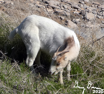
Is this Billy Goat Gruff?
 

Before we got very far, there was a hawk-maybe a goshawk-just sitting high in a tree. He checks us out occasionally just to make sure we will not be messing with him-which we do not. So I get some pretty good pictures of the hawk. Then it is onward.


Sherri climbing up the the Cemetery

The South Shore Trail is 1.7 miles long and pretty level, maybe with a variance of about 50’ or so. Still you are on the side of a hill with Millerton Reservoir on the other side. We have hiked this several times, the first time in a drizzle-it is that kind of trail where you can enjoy the walk no matter the weather. Well maybe in the middle of Summer you will want to get an early start. Today not only did we get a hawk, but two goats were on the trail. We approached them carefully. They finally moved, much to their annoyance.


Winchell Cove Cemetery
We rounded a point and entered Winchell Cove. Then the pit stop at the outhouse at the end of the trail. We still had a little more time to hike, so we went around the end of the cove and went to the Winchell Cove Cemetery. When the Reservoir was created, they had to move various things like the original courthouse of Fresno and Ft Miller. There was also a pioneer cemetery which got moved to a point along side of Winchell Cove. In 2007, an Eagle Boy Scout project renovated the cemetery.
There is still a little more time, so we head up the slope-this is most of the elevation gain for today. I would classify this as a journey hike. We get to a place on the side of the ridge and decide to make it back, we needed to turn around. Still a nice walk.
The trail beyond the Cemetery

The trip back is mostly a reverse of the trip in. Except we do follow the trail down to the end of the cove. The goats have moved themselves so we are able to pass through. There are a couple of kayakers on the lake. Wait, one is calling out to us. It is one of our hiking buddies-Bill and his friend Leland. We talk, or I should say yell, for a few minutes. Then we both depart our separate ways. We get back to the car at 2:00 and are off.


Bill is on the left
We stop at Costco on the way home and are back at our house by 3:15. I am getting stronger. This is good and it was a good hike.


Hawk in flight


Extra Photo's

The Glass House
View of Winchell Cove from the Cemetery

The other arm of Winchell Cove

Sherri either admiring the view or waiting for Gary

Little Shuteye Peak

Shuteye Peak

Animals

The goshawk eyeballing me-he is big, but is he tasty?

Add caption

One of our goats

Same goat

What kind of a nest? Maybe an eagles?