Showing posts with label Corrine Lake. Show all posts

Wednesday, January 8, 2025

January 8, 2025 - Corrine Lake

Title: January 8, 2025 - Corrine Lake


Hike Info:

Type: Hiking

Trail head: Corrine Lake Road

Trail: Corrine Lake Road

Destination: Corrine Lake

Distance:  6.44 miles

Start Time: 11:04

End Time:    2:45

Travel Time:  3:41 (1.75 mph)


Moving Time:  2:51  (2.26 mph)

Elevation Rise:  623'

Descent: 615‘

Maximum Elevation: 2,535'

GPS Tracks


Description:

Flume from Manzanita Lake
I woke up this morning with the skies just starting to turn pink. Judging by other Facebook posts, other people noticed this pinkness as well and were in awe of it. Then I bought time by doing odds and ends until everybody was ready to go, about 10. The everybody is Steven, Korra, Sherri and myself.

It does not take long for us to drive up Highway 41 to the road going over to North Fork. We turn onto Road 222, keeping a sharp lookout for Corrine Lake Road. Once we find it, we turn off and travel about 100 yards where there is a wide spot on the road and park there. This is where the flume reconnects with your road.

At 11:00, our boots hit the road. Our pathway will take us along the dirt road until it becomes a PG&E road where it mysteriously gets paved. But that is about two miles or so walking from now. The road rolls up and down ridges with the flume following us or going through ridges. Some of the time it is rather plain. But other times the tranquility of gently flowing water is mesmerizing.


Water is not the only attraction. We pass by houses of people who are probably trying to escape from the Life in the city. We have one episode of dogs wanting us out of there, which we gladly accommodated. In the distance we see the Dhamma Mahāvana. At least it was in 2018 We roll through the hills which give the greenness as if it was Spring.


Hiking the road


Before we get to Corrine Lake, there is a long decline, followed by a rise back up to the Lake level. Before seeing the Lake, we stopped at an outhouse. Then to the Lake. There is a guy fishing, but he says that he is not having any luck.

One of the virtues of this Lake is that it had a tendency to reflect the hills and mountains around it. There are high clouds today; the contrast of blue and white with the mountains creates a sense of awe. We settle down at the west end of the Lake and have our lunch. It also gives us a chance to rest and take it all in.


After about half an hour, we took our leave of the Lake. We set a nice pace back. Coming in, we saw a dead animal in the road. The guesses if what it was were a black squirrel, possum or a skunk. On the way back, we looked a bit closer-not too close-and determined that the skunk guess was correct.

We get back to the car about 2:45 and the motor starts about 3. Are we hungry? Steven answers yes. We have eaten at a BBQ in North Fork and will see if it is still there. It is. It is a Veteran run restaurant, called North Fork BBQ, of all things, and serves pretty good. I have the Yosemite Yardbird-chicken; both Sherri and Steven had the Carolina Pig. It takes about half an hour to devour our meal before we head out. The trip back is uneventful.


Extra Photo's


Flume from Manzanita Lake to Corrine Lake

Fence post laced with woodpecker holes

Steven and Korra

Drain into Corrine Lake and the long uphill out of it

Corrine Lake

Corrine Lake

Gary

Flume under the ridge

View to the west of the road

Corrine Lake


Sunday, February 24, 2019

February 24, 2019 - Corrine Lake


Title: February 24, 2019 - Corrine Lake
Hike Info : Description :   Extra Photo's 


Trail head: Corrine Lake Road
Hike Info:
Type: Hiking
Trail: Corrine Lake Road
Destination: Corrine Lake
Distance:  6.07 miles
Start Time: 12:53
End Time:     3:34
Travel Time:  2:41 (2.26 mph)
Moving Time:  2:09 (2.83 mph)
Elevation Rise:  705'  1
Descent: 712‘
Maximum Elevation: 2,541'
  1The GPS did not register the elevation. The elevation information is from Google Earth.
Description:
Sherri’s and mine first time organizing a Meetup hike since April. So I am a bit apprehensive about doing this event. The route is not an issue-just follow a dirt road. But just doing this. Fortunately it is a small group whom I have hiked with most of them before.
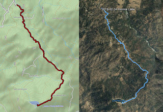
Our path
We go to church, then get ready. We leave our house at 11:05 and get to the parking lot at 11:20. Lori is waiting for us. John, Tom and Daniel shortly afterwards. We wait until 11:40 before leaving-missing one person. The trip up to the trailhead was pretty quick, about an hour. We see Pam parked at the Road 222 and Corrine Lake Road-she had gone up and down the road to Corrine Lake. She wants to only walk the road again, not drive it. A little while later Daniel drives up-he has gone all the way down the road aways. We are missing one other person, but Pam says that that person is not coming because their dog ended up in Emergency. I should say we have four dogs on this hike. They pretty much are well behaved.
It is approaching 1:00pm and we are all ready to move on. The weather is clear and crisp, just right to start walking. We follow a flume along-this flume comes from ManzanitaLake and feeds the PG&E lake we are going to. We will follow it pretty much all the way. Sometimes it hides in the hills or decides to meander away, but it will always come back to us.

North looking

But the meandering is part of the fun of this walk. Green hills, blue skies with a background of white mountains. Good hiking eye candy. Sherri, Pam and I sort of lag behind everybody. On my part, it is comfortable walking. The rolling hills do not seem to tax me too much, unlike a few previous hikes I went on this year.
Most of the way is on dirt road with ranch houses towards the side. I think there is forest service land around us as well. Soon we come to a gate with pavement. This seems like it is PG&E land. The dirt road is a bit easier on the legs, but the paved is still pretty good. The water seems to be moving faster-probably an optical illusion. But we turn a corner and head the quarter mile more to the lake. I make a pit stop at the outhouse by the power station, then join the group at the lake.
Flume
Corrine Lake is small, maybe just slightly larger than a pond. While easy to get to, we are the only ones there today. Nice to spend a few minutes relaxing by the lake, looking out at the snow covered mountains-actually the snow is a lot closer, maybe at the 4,000’ elevation or lower. Restful. Evidently, not all that restful as Pam, Daniel, Tom and John decide to walk around the lake with the dogs.

By the time they get back, it is time to start heading back to the cars. We retreat down the same road we came in on. This time, I am walking with John, Tom and Daniel. Not a fast walk, but one which I can sustain. We talk about different things. Along the way, we admire the work of over-achieving woodpeckers on some fence posts-sorry no pictures. The walk back is just as pleasant as going out.
Bass Lake and ice

We get back to the cars around 3:30. Usually it is a time for an after hike meal. But the only place I know of in North Fork is closed on Sundays. So we all congratulate each other on a good hike and head off towards home.
Well not all of us. Sherri would like to see the iced over Bass Lake, so we go through North Fork and come to Bass Lake through the back way. The northern part of Bass Lake has ice on it. Definitely do not want to be out with skates on the feet-even if I could ice skate. We decide to have dinner in Oakhurst. We choose El Cid and get stuffed. Now it is time to head back to Fresno.


Extra Photo's


View to the east

 
Southwest looking


More snow covered mountains


Boots and water

Still more snow

 
Flume

 
More of the flume


Bass Lake


Saturday, February 24, 2018

February 24, 2018 - Corrine Lake


Title: February 24, 2018 - Corrine Lake
Hike Info : DescriptionBackgroundFlowers and Plants
Hike Info:
Type: Hiking
Trail: Corrine Lake Road
Destination: Corrine Lake Road
Distance:  6.53 miles
Start Time: 8:06
End Time:  11:23
Travel Time:  3:16 (2.00 mph)
Moving Time:  2:21 (2.78 mph)
Elevation Rise:  736' 1
Descent: 453‘
Maximum Elevation: 2,555'


  1For once, the elevation rise seems more correct than the descent. I am including the profile from Google Earth as well, which confirms this.

Stopping by Corrine Lake

Description:
It rained, and then snowed up in the mountain Thursday. Friday, it turned pretty cold. Our original destination was the Merced River Gorge, starting at Briceburg. First, one of the people said they would be going to Mariposa via a different route. Then I saw a picture on Facebook of the snow in oakhurst-about 6”. Then all the highways in the area had some sort of chain control at some point. So we decided to move the hike to Corrine Lake from Briceburg. Then to confirm our decision, I saw an article about the many traffic accidents along 41. So spent a good part of Friday night notifying people of the change in plans.
Towers on a mountain-maybe Black Mtn


Saturday morning breaks and it is COLD down here in Fresno. Below 30 degrees. This California boy is feeling it. But we meet people in the parking lot-there are seven of us going. I think the weather and all got people to reconsider. Looks like an enjoyable group though. Only Carol and Eileen we have hiked with before. But looking forward to hiking with Marie, Thomas and his friend Robin. It is time to leave at 7:00am. We go up 41 until the North Fork turn off. Then follow that road for 16 miles, until right before North Fork. We follow Road 222 for a couple of more miles until we see the flume and turn onto Corrine Lake Road. You can drive this road in all the way to the Lake, but we only go in about a quarter mile to a wide spot on the road.


View to the North
 
We could have driven all the way in, but what fun is that? The seven of us get out. I make my speech-really quick for me, after it is cold, and then we take off on our walk. It looks like going over I am walking at close to a 3mph pace. I am content with that. Not breathing hard and the legs are not complaining. I talk with Robin a lot-we have been involved in similar occupations. Much better than Wednesday’s hike where about half way through my legs gave out. By the way, there are spots of snow in the shadows, but nothing on the road.
Exiting the lakte
Either because of the conversations, freshness of the air, or I am stronger than last Wednesday, the miles seem to be rolling by. I notice I am not taking many pictures, but that may mean I have not had a need to stop very often. We hit a part of the road which is paved. This leads us right to the pumphouse by Corrine Lake. There is a clean outhouse here which many of us find convient. Then we wander to the far side of the lake.
Flume entering lake
From here, we have a discussion of the various peaks around us. We think there is something towards the Southeast. Maybe a lookout? But maybe not. Thomas knows the area pretty well-I do not know it by sight. So he starts to name off the peaks and stuff. I make a comment that the center of California is just down the hill from here. In looking at some maps, I think I had the right idea, but maybe not the right direction or distance.
The lake itself is small, maybe a football field plus in length and half of a football field in width. With little or no wind, the streams of clouds reflected on the water-I think Sherri was able to capture some of that.
After talking a bit at the lake, we started on our trip back. Coming over, we only saw some barking dogs and a few hawks as far as animals. Coming back, we saw one hiker crossing our road and taking off up a hill. None of us gave chase, but all were wondering where was he going. Also two vehicles traveled the road-both seemed to be intent on fishing the lake.
Spotted Slash Pile Smoke


We are a bit slower coming back. Not so much from being tired, but stopping to look at a few things. Such as there was several slash fire burning. So we tried to identify places where they were. On one of them, flames could be seen. But then a building caught my attention. Its golden, pointed roof is unusual. Some kind of temple or something, I think. Or maybe an alien spaceship in disguise. I do not know. We also talked about some of the fires in the area, both around Corrine Lake and at Cascadel Woods.
We get back to the car pretty early for our hikes-about 11:20. We suggest that we can eat at La Cabana in North Fork. Seems like a good idea to all, so we head over there. Lunch is good; all are content. Then off we go, back to Fresno. Sherri and I get home at the remarkable early hour of 1:30.


Background

Center of California. The exact geographic Center of California is at 37°09′58″N 119°26′58″W. It is about 50’ off of the road and requires a bit of stair climbing to get there. To find Cal Center, travel 4.7 miles east from downtown North Fork along County Road 225 toward the Sierra Vista Scenic Byway, then turn right onto Italian Bar Road (still Road 225) toward Redinger Lake. Travel about 2.7 miles and watch for the CAL-CENTER sign on the left. The stairway rises about 21 feet to reach the compass rose at the exact center of the state. From the Sierra News Online. There is also a Huell Howser episode on this spot from 1995. 
====== 
Gold Topped Building
The golden topped building we see off in the distance is called Dhamma Mahāvana, a branch of the California Vipassana Center. From their web site, it means: Vipassana, which means to see things as they really are, is one of India's most ancient techniques of meditation.
=====
Fires. There is several fires which has gone through the area where we hiked, or close by.
Sierra News Online article on Sept 11, 2017.


Flowers and Plants
Lupine


Saturday, February 6, 2016

February 6, 2016 - Corrine Lake


Title: February 6, 2016 - Corrine Lake
Trail head: Road 222, out of North Fork
Hike Info:
Type:  Hiking
Trail: Road 8S48
Destination: Corrine Lake
Distance:  6.52 miles
Start Time:  9:07
End Time:  12:13
Travel Time: 3:05 (2.11 mph)
Moving Time: 2:38 (2.48 mph)
Elevation Rise: 748'
Maximum Elevation: 2,557'


Description:
Generally I do not like hiking dirt roads, and today's meetup hike is along a dirt road. So we shall see how I like it. We gather at 7:00am in front of Eddie's Bakery, 22 of us; many I know and some will be new to me. Bruce who is leading this hike is new to me, but from my understanding he has a vast amount of experience. Always interested in another person whose brain I can pick.

The hike starts a little out of North Fork, along Italian Bar Road where the Exact Center of California is located-but that is further down the road. Where the road crosses a flume coming from Manzanita Lake. We will come familiar with this flume as we walk today.  We park a couple hundred yards on the Corrine Lake Rd, at a wide spot and take off down the road.

One of those trees
This road turns out to be pretty nice to walk on. We able to hold conversations, many people abreast. The hills are rolling, making for a bit of exercise. Sometimes you get these dirt roads being pretty dusty, but either because we are in winter or the clayishness of the dirt, the footing is firm.

But what makes this hike good is the trees. I am a sucker for oak trees, particularly when they silhouetted against the sky. There is something which makes me just want to gaze at these trees. I cannot say they are stately or awe-inspiring. Maybe it is that they survive and thrive against odds. Whatever it is, they cause me to look and enjoy, and that is what this walk is doing for me, causing me to enjoy these trees.

Flume at our parking area
The road does follow the flume as it flows in and out of hills, or goes under the road and disappears someplace only to reappear again a half mile later. Sort of fun to ponder this and where it comes from (Manzanita Lake it turns out.) . John's and mine ponder picks up the pace when we notice a pumping station along the flume. Why would they have a pumping station? For what purpose? Corrine Lake is a bit higher up than the flume. But if the water is to create electricity, why pump it higher? These life questions one ponders while we are walking.

Speaking of Corrine Lake, we have arrived there. This is a man-made lake, almost rectangular with a pumping station on one end. We can tell where we walk over the penstocks. There is a small point where we can look out over the San Joaquin and where I think the Million Dollar Mile is. We break here at the lake and I pass out my brownies, which are appreciated.
Corrine Lake


Pumping/Powerhouse at Corrine Lae

Ducks on Corrine Lake


Across the San Joaquin River
Now it is time for our trip back. Sort of the same walk back. Jeffery, Jerry K and another are picking up garbage as they go along, including an assortment of what may have been balls in a previous life. That gets things into a playfull mood. Before we know it, we are back at the cars.

Walking the Road
Of course, what is a hike without stopping for eats. So we stop in North Fork at a Mexican restaurant called La Cabana. Food was pretty good.  Not quite set up for a large group, but we make do. As we were leaving, Cathey asked about some neighbors of ours. Turns out they are in the restaurant, so I turn around, go in and talk with them for awhile. At this point, one of our hikers discover that her wedding ring's diamond had gotten lose from its settings and was lost. We looked in my car and around the restaurant and could not find it. That set a low tone for our drive back. But we got back to Fresno safe, but a bit tired.