Showing posts with label Abbott. Show all posts

Sunday, September 3, 2023

September 3, 2023 - Delilah Lookout


Title: September 3, 2023 - Delilah Lookout
Hike Info : Description :   Extra Photo's : Animals : Flowers and Plants
Hike Info:
Type:Lookout
 
View from my walk
 Description:

I woke up a little after 0600. I checked for lightning and there was lightning reported, even the ones missing from yesterday! It took me about two hours to produce the report. The turmoil and trauma of using a small laptop. But if this is the worst my life has, I will not complain.

During producing the lightning report, the skies went from having a high cloud ceiling to enveloping us. Also there was some precip which blessed us. By the time we went into service at 0930, we reported .02” of rain and limited visibility.


Lookout view
When I finished my report, we had breakfast-oatmeal, granola and a cinnamon roll.The same as yesterday. While Sherri went downstairs, I washed dishes. It is going to be that kind of day where you get to hear about the minutiae of life in a lookout. Sherri heard some voices-turns out there were three motorcycles down by some trees at the start of the loop around Delilah. They do not come up-I do not blame them with our visibility.


Delilah in a cloud


When Sherri came back, I went down. I also went for about a half an hour walk down into our saddle, beyond and up. Usually there is two to five deer wandering around the lookout. On this trip, I saw only one and he crossed my path on the walk. Even though it is a bit late in the season for wildflowers, there still was a couple


Lunch
When I got back, we settled into life in white out. That is, I have my quiet time and work on my blogs. We listen to the radio and wonder how a car got stuck in Abbott Creek last night. But then even more so, how did it get beyond a place where a tow truck got stuck today? The things we hear. As a note, later in the day, we heard that another tow truck was sent to bring out the first on. The car? I think they will wait until things get dried out to bring that one out.

And then there is the continuing saga of the Province Fire. The firefighters brought down a 100’ fir tree which was burning on top and now are dealing with the fire on the ground. They could not bring in aircraft because, you guessed it, no visibility--too much cloud cover. We were then hearing about activity around a Lost Meadow. After searching for this meadow on a map, we found it. The question in my mind is, if we found Lost Meadow, is it lost any longer? There is smoke reported back in there as well-it is only about 2 or 3 miles southeast of the Province Fire. In looking at my lightning report, there is also a strike someplace in that area.


The Outhouse View

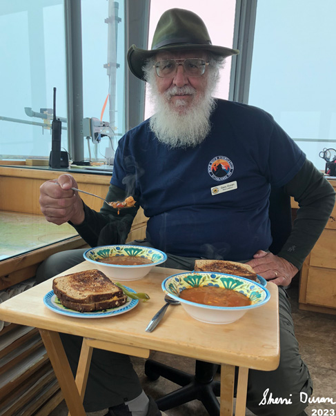
We decided that since we are not doing anything, lets have dinner now. Sherri heats up soup and fries us a grilled cheese sandwich. A pretty good meal to have on a cold day.

Surprisingly, we have had two sets of visitors-one person from Clovis and two from San Jose. There is some disappointment in traveling all this way just to see the white of the inside of a cloud. They both had been to lookouts before, without our view, I am left to babble and there is only so much I can say before they look at me and I look at them.

After the last couple of days, we are a bit lethargic. We read and write and just enjoy the down time. There is something hypnotic about being surrounded by a sea of white. No temptation to dive in. Maybe if it was a bit warmer. With the temperature outside hovering in the low 50’s, there is not much temptation to go outside. I do take a nap, which terminates about the time the San Jose visitors come up.

Around 1700, the clouds start to part and we get to see the land again. Even though we have seen this land for many years and have had no reprieve the last two days, it looks different now that we have been deprived of it. Is this true of what is common becomes desired if we cannot have it?

With the land visible, I start to do scans. I do not expect to find any fires. First, with all of the clouds, there has not been lightning in our area. Second, the area has been pretty moist, so it will be hard to start a fire without human aid. It is Labor day weekend, so there is bound to be someone who doesn't believe they could be the villain. Part of our task to find if this happens in Delilah territory.

At 1900 we go out of service. Even with the lack of visibility, I enjoyed the relaxed nature of the day. We finish out the day with a peanut butter sandwich. Then we go on a short walk.down to the saddle . Sun sets when we reach the saddle and in the fading light we make our way back up to the lookout for the night. It is dark, but it seems too early to call it a night. So we read and talk. I lay down around 2115 and fall asleep at 2200-Sherri is making sounds like she is asleep well before me.


Extra Photo's


All we can see from the catwalk

Start of no visibility

Gary at lunch


Animals


Flowers and Plants

Clarkua biloba

Common Madeea


Saturday, September 2, 2023

September 2, 2023 - Delilah Lookout


Title: September 2, 2023 - Delilah Lookout
Hike Info : DescriptionBackground : Extra Photo's 
Hike Info:
Type:Lookout

Description:

I woke up a couple of times last night to go pee. But at 0400 I woke up again and realized a couple of things: I needed to go pee again and it was raining. The first I try to ignore, but the second becomes urgent when a light flashes across my eyelids: lightning! The opening of my lightning report says it well

Clouds below Delilah
There is nothing like the gentle patter of rain on a tin lookout roof to awaken you at 0400. And then the flash of lightning at 0415 to get your heart beating faster. And now there is the gentle sway of Delilah in a pretty good wind to get me going. And when I opened the door this morning, there was the smell of smoke-but none observed yet coming from the ground. So you are getting this lightning report straight from a direct observer as well as my usual source. Even as I am writing this email, the area around Buck Rock is getting additional lightning-looks like on Spanish Mountain.

For the next hour I sat on a lightning stool. Sherri stayed in her bed. Once the threat of lightning went away, I fired up my trusty laptop and put together my lightning report. And now my troubles begin getting out the report. I got a couple of strikes from yesterday, which does not surprise me. But where are the strikes from this morning? Maybe I tried too quickly? I inquired again and again for another hour, and still got nothing. So I issued the report with only yesterday’s lightning with the caveat that this morning’s lightning was missing.

Where is Smith Meadow
We have our breakfast of oatmeal, granola and a cinnamon roll. Then after Buck Rock goes in service at 0728, we go in at 0730. Buck Rock does not have visibility-and as it turns out this is for most of the day. We both have had precip-he reports wind and we report lightning. And now begins our long 11 ½ hour day on duty.


Gary trying to see smoke from Smith Mdw

Most of this time is spent doing scans, listening to the radio and lounging around. Our visibility is about 10 miles, But there are so many water dogs and low clouds that I am not sure we would be able to find a fire even if there was one. Several of them give me pause, such as one on Dude Ridge where the water dog looks like it comes from a stack of wood. I stared at that for a long time before deciding it was not a smoke. We also took the weather-no worries about low humidity.

Ar 1000 there is a report of smoke at Smith Meadow. Where is that? Once we figure that out, we start looking for smoke in that area. Smith Meadow is just south of Wishon. We cannot see into the meadow, but the area around it. There is a big, long, gray cloud stretching from where the meadow is westward to close to Black Rock. We radio in what we see. Also if this is a smoke plume, which we have our doubts, that what we are seeing is a smoke. Sierra gets a response team to identify where the smoke is. There is an occasional question throughout the next several hours on what are we seeing? Just more clouds. Also one of the patrols emails me and wonders if I have anything further on the lightning from this morning-nothing. By mid-afternoon, clouds have come into the area. Also the roads in the area have been impacted by Hurricane Hilary. So they have looked over the area, they call off the search for the fire.

Could you spot the smoke? Bottom frame-filtered

While we are looking into this area, we scan in other areas with negative results-like a COVID test, this is good. But we do pay attention to what is going on around us. Near Woodward Creek, there is a tree threatening the General’s Highway. So Division 3 gets a crew together, including a borrowed frontloader to bring down the tree and clear the highway.

Or later on that afternoon, there was a report of a lost group down in the Millwood area. So a patrol is sent down road 13S70. He eventually found them: in Abbott Creek. First the people had gotten hung up on a log and in the process of freeing the vehicle, it ended up in the creek. This was a job for tomorrow to bring in a tow truck to get the vehicle out. Tomorrow there will be a continuation to the story.

Then at 1627 there was a report of a fire in Watts Valley. We should be able to see this. But there is a lot of haze today which is blending anything white with it. But after looking for about 5-7 minutes we are able to see it coming over a ridge to the east of Hog Mt. We report what we see to Sierra. It is a Fresno-Kings CalFire incident. So we tune into a CalFire station. We see the smoke decrease and disappear.

We usually go out of service at 1800. But being a holiday weekend, we have been asked to stay on until 1900. This is better than the 2000 which we do on other holiday weekends. Nothing else happens to us. There is a fire in Sierra National Forest called the Providence fire, but it is beyond what we can see. Sounds like it is a single, large tree.

We have our dinner, a pulled bar-b-que pork for dinner. No, Sherri did not roast it up here, but had made it Thursday night for dinner. Still tasty after a long day. After going down, we hit our beds around 2100. It has been a tiring day.


Background 

 Lightning Stool. I should add or chair. While the lookout is pretty well grounded, occasionally a lookout is struck, after all, it is a steel structure sticking high up in the air. To doubly secure the lookout, there is both a stool and chair in each lookout with the old glass electrical insulators attached to its legs. The idea is that if there is any electrical seepage from a lightning, the glass insulators will provide a barrier to electricity.
 
Extra Photo's
Evening Clouds

Looking east from the base of Delilah

Clouds by Goat Saddle

Park and McKenzie Ridges

Where we were trying to spot a smoke

Pine Ridge Clouds

Clearer picture of Watts Valley Smoke


Tuesday, February 7, 2023

February 7, 2023 -North Boundary


Title: February 7, 2023 -North Boundary


Hike Info:

Type: Snowshoeing 

Trail head: Highway 180

Trail: North Boundary Trail

Destination:  Go up the trail as far as we feel like

Actual Destination:  Abbott Creek

Distance:  1.47 miles

Start Time: 1:28

End Time:  3:23

Travel Time: 1.54  (0.78 mph)


Moving Time:  1:20  (1.10 mph)

Elevation Rise:  349'

Descent: 339‘

Maximum Elevation: 6,949'

GPS Tracks


Description:

Sherri-first time on new shoes
Today we had scheduled a day up in Yosemite to take a friend who wants to see the Valley in Winter. But it looks like he has a conflict. So Sherri and I have decided to go to the Grant Grove area instead. We leave about 11:30 and get to the parking area by 1:00. On the way I ask the entry station about getting to Big Meadow. He does not know how long it will be closed, but he thinks it will be a couple weeks still-the area north of Ash Mountain is still a mess.

We eat lunch and do not get started with our snowshoe walk until 1:30. Sherri is on her new snowshoes. After observing my shoes, she got the same model, MSR’s Lightning Trail. We will see how she likes them after our time out today.


Unbroken snow-our trail
The first obstacle on our walk comes up quickly. The snowplow has thrown up a lot of snow, making it hard to get going. But we do. There is not much in the way of tracks. But I can follow the trail well enough. There is a telltale indention in the snow. Later on the indention will turn into more of a wide shelf which I am able to follow well enough.


Sherri climbing


Also the trail goes up pretty steeply. I am feeling pretty good about how I am going up this. The snow is pretty much settled, so even with my weight, I do not sink down more than an inch in most spots. I guess when the last storm came through last weekend, this area did not get much snow. Sherri is going up a bit more slowly, but she is going up and that is what counts.

We come to one of the forks in the trail. The lower one goes off and eventually meets up with the road up to Panoramic Point. We choose the higher one and continue our progression up. There are lots of downed trees. Most of them are pretty well buried. But there are a few which offer a bit more of a challenge. But we conquer. They only slow our progress.

But what stops our progress is a small tributary of Abbott Creek. There is not much water, but there is a moderate amount of difficulty climbing the far side of the rivelet. We stop, take some pictures, admire the beauty and decide that we did not want to put forth the effort. Besides, we could only go on for another 40 minutes-I had set a 3:00pm turnaround time.


Abbott Creek

Side trail
Going back down the trail is both faster and easier. When we got back to the junction, we decided to take the other way. The path is a bit harder to follow. But the good thing is that we are on snowshoes. The worst which happens is we follow our tracks back. But evidently I am following the clues right and the path is before us. But after a little ways, so is that tributary of Abbott Creek.This time instead of one side being sheer, both sides are, something like around 4-5’ on each side. Reminder to Gary-pack a small snow shovel. I think we could have gotten over Abbotts by digging steps.

And so we backtrack to the main trail. And now we head back to the car. Not really anything noteworthy, except I notice a few footprints in the snow. Evidently someone had been up a few yards after us. We got back to the car a little before 3:30.

And then back to Fresno. There was a boulder in our lane. When we get cell reception, we call it in to the CHP. We get back home a little before 5. Steven goes out and gets us a Habit burger which gets eaten during the State of the Union address. After all of this, I am a bit tired and ready for my 10pm bedtime.


Extra Photo's

Sherri just about back to car

Sherri on the home stretch

Burnt Tree

Sherri avoiding a tree

Icicles over Abbott Creek

Gary by Abbott Creek

Gary by Abbott Creek

Thats the trail


Tuesday, September 27, 2022

September 27, 2022 - Princess Campground and the North Boundary Loop


Title: September 27, 2022 - Princess Campground and the North Boundary Loop
Hike Info : DescriptionExtra Photo's : Animals : Flowers and Plants
Hike Info:

Type: Hiking 

Trail head: Grant Grove Parking Lot

Trail: North Boundary Loop Trail

Destination: Loop 1


 1I did not turn on my GPS. I discovered this a good way through our walk. Sometimes it is good to be free of that burden.

Description:

I woke up at daybreak this morning. Sherri is just returning from a trip to the little girl’s room. And I go off to make my own trip. Then I go and observe the meadow in the morning. Having seen yesterday’s meadow picture, you can understand how radiant it can be when the new sun shines through it.

Gary after retrieving backpack
Today is the last day of our trip. It is always a bitter-sweat time, no matter how long or short the trip is. There are regrets in leaving a place which I enjoy; doing stuff I like doing. But there is also the call of home, with its comforts and showers and routines well known which I find contentment in. In this case, it is the continued work of tearing out the front lawn and putting a front which is more water efficient.

As we get ready to leave, we have already talked about returning and other trips. But will we make that effort? I hope so. Our last breakfast is oatmeal. By 10:20, we have broken camp and are heading towards Grant Grove.

The General Grant Tree Parking Lot is a short distance away, so we have our boots on the ground by 10:50 and walk the North Boundary Trail Loop. About a hundred yards onto the trail I realized something-I forgot my pack. So I go back while Sherri continues up the trail. Later on I discovered I did not turn on the GPS either. I guess it will be one of those days.

Sherri among the Sequoia
We take the less traveled way to begin our trek. There is a small, unnamed creek which goes east from the parking lot. We follow that for a short way, then cut over to the General Grant Tree. Beyond the General Grant Tree is the Gamblin Cabin and there is the short connector trail to the North Boundary Loop.


We go counter-clockwise and meet the first obstacle: a fallen tree across our path. But it has a slight break which allows us through it. We see parts of the upper pieces of the Grant Tree. But what amazes us even more is about a 30’ section of trail just littered with Sequoia cones. We have seen many Sequoia cones, but never so many in one place and so green, like they just dropped.

Beginning of Autumn

The day is warming up and I can tell I am not moving very fast, but neither is Sherri. Guess that makes us a good pair for this hike. We get to the junction which goes to the horse corral and then head more northwest to the edge of the Park. This climbs a ridge which overlooks Abbott Creek. By this time, it is noon and I use the excuse of waiting for Sherri to stop and rest for about 20 minutes, looking up at the clouds passing overhead. Poor Sherri only gets 17 minutes.


Matchstick Tree
This ridge is the edge of where the Rough Fire back in 2015 burnt to. It is a good example of why prescribed burns are so effective. This section was burnt a couple of years before the Rough Fire. When that intense fire came, there was a lot less fuel to burn and it just stopped, unlike the western end of the grove where large trees were burnt to matchsticks. .

Then coming down the ridge, we descend into a sea of green brush-where the land is recovering from the fire. In the midst of green, there are a few flames of red showing that Fall is right around the corner.

There is one more ridge to climb. And when we reach the top of this ridge, we keep with tradition: we have our lunch break. From our vantage point, we can look down onto the paved trail which goes to the General Grant Tree. So we know our path is coming close to an end. We, or maybe it is I, who decide, let's not do the North Grove loop. We do complete the North Boundary Loop, going through the Grove, back to our car.

By this time, it is 2:30 when we get the car going. We reach our home in Fresno around 3:40 and unpack. I am tired, but good. A shower always feels good after a trip like this. When Steven gets off of work, we send him out to the Doghouse Grill for dinner.


Extra Photo's
Early Morning at Indian Basin

Unknown Sequoia

Gary chugging up the trail

Looking up at the young trees touching the clouds

Brush growing up after Rough Fire

Delilah Lookout


Animals


Flowers and Plants