Showing posts with label Valley Chapel. Show all posts

Friday, April 19, 2024

April 19, 2024 - Yosemite Valley


Title: April 19, 2024 - Yosemite Valley
Hike Info : Description : Trail Lessons : Animals 


Hike Info:

Type: Hiking

Trail head: Camp Curry Parking area

Trail:  Northside Drive, Yosemite Village, Valley Loop Trail, Lower Yosemite Falls Trail, Cook’s Meadow, Southside Drive

Destination:  Loop

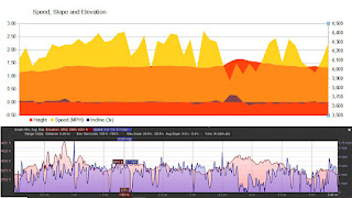
Distance:  4.39 miles 1

Start Time: 2:10

End Time:  5:10

Elevation Rise:  678'

Descent: 676‘

Maximum Elevation: 4,107'


 1I forgot my GPS. So I plotted out the route on Google Earth. So this will not have been the exact mileage and time. Steven’s Strava recorded 5.5 miles. He did make an extra trip of about half of a mile. So I think the truth is someplace between 4.4 and 5 miles.


Description:

This was going to be a long day as I needed to repair a sprinkler pipe before we went to Yosemite. It got even longer that evening. The first was planned while the second was thrust upon us.

Lunch at Cathedral Beach-Sherri and Steven
I got up at 6:30. I finished repairing the pipe, then let it set while I had breakfast. After that I tested all of the sprinkler lines and they looked good. I got all of this finished by 8:30. So why didn’t we start sooner? First, I was relaxing a bit and then I think everybody was waiting for everyone else to say they were ready. That was the state until Sherri came in at 10:40 and asked if we were still going to Yosemite? Yes was the answer.

So we got ready in about 25 minutes. Sherri got us out of the garage by 11:05 and drove us to Costco to get gas. Then she drove straight through to Chinquapin. By this time, she had enough of driving and Steven took us down into the Valley.


Vows were said here

Unless we have company, we usually do not stop at Tunnel View-usually too crowded for our tastes. Today we did not stop, but there was plenty of room. It will not be that way in a couple of weeks. The
Bridalveil parking area is open, looks crowded, but a lot better than before the construction of the past couple of years.

Steven has a destination in mind for lunch. That would be Cathedral Beach
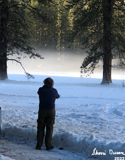
Mist from Yosemite
. We arrived there at about 1:45. This picnic area has a special place in our hearts. It is where Andrea and Lawrence got married last October. Certainly looks different without the table covering. Also the Merced River is higher, much higher than in October. If they had gotten married now, the water would have been above their boot tops.

We continue on to Camp Curry’s parking lot. This area is also under construction. But fortunately there is a lot of parking. We only decided what we were going to do a few minutes before driving in. The thought was to go up to Vernal Falls. But I suggested just walking around the Valley. A couple of days ago I strained my hamstring muscle and I am not sure about doing any steep climbing. It is too late to go around Mirror Lake. The decision was to walk around Yosemite Valley, heading towards Yosemite Falls. By the time our boots hit the pavement, it is 2:30. Sherri has discovered she is missing her phone. I guess she will need to rely on Steven and I for pictures.

Gary, Steven and Sherri


 Our goal is to walk the relatively level route to Yosemite Falls. The road by Stoneman Meadow is being revamped. Maybe into a bikeway connector? It does change the traffic patterns, for the better. We get a good view of the Royal Arches. But it is a relatively unshaded area. So after a quarter mile, Steven decides he needs his hat and goes back for it. 

Sherri and I continue on towards the Visitor Center. We passed by Ahwahnee Meadow and into the Yosemite Village area. It is just pleasant walking and surprisingly there are not the usual crowds of visitors on this Spring day. When we get to the Visitor Center, actually by the Ansel Adams Gallery, we wait for Steven. But there is a new Welcome Center and Steven thinks we are there. So Sherri and I get a good rest before Steven joins us. By this time it is about 3:20.
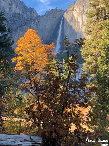


Yosemite Falls
We head west again, getting to the Yosemite Cemetery which Sherri starts to head through. This is OK with me as I am interested in the names I have seen here. While the cemetery is not well protected and has a very low fence to mark its boundaries, it does seem wrong to purposely use it as a shortcut. That is not Sherri’s intention. So we go around the cemetery, past the Law Enforcement area and up the short trail besides the stables. This leads us up to the Valley Loop Trail.

Yosemite Falls


Along the way up to the Loop Trail, we spot a mountain quail. Much more attractive than the quail we see around D
elilah. Once on the Loop Trail we continue our westward trek and come to the bridge crossing Yosemite Creek. But before that, we see signs that the Falls are coming. First, there is the mist flowing well above the trees. Then there is Yosemite Creek thundering past the trail. And now crossing the bridge, we feel the wind created by the force of the falls. The sight of Yosemite Falls never fails to elicit a sense of awe.


We continue on our walk down to the Yosemite Falls Bus Stop. There are two women parked in the bus place, but it looks like they are pretty agitated and there is no bus while we are waiting. And while we wait, we consider the new bus routes. This bus will go all the way to the Pohono Bridge. So we decide to cross Cook’s Meadow and go to the Sentinel Bridge Bus Stop. Crossing Cook’s Meadow gives a great view of the eastern end of the Valley. So we take our time and walk through there.


Briefly after arriving at Sentinel Bridge we enjoyed its seats. That is until we realize that this is no longer a bus stop. Yosemite has been working on getting a better traffic flow around the Valley. It looks like as part of that, this stop has been discontinued. The traffic looks like we are in England as the flow has vehicles going on the wrong side of the road, that is the left side..

Indian Canyon Falls

So what to do? Sherri would like to go to the Chapel, so we go there. It is a short walk to it, maybe a quarter of a mile. The chapel is the oldest building in the Valley. But it used to be a few miles west of its current spot. The doors are open and we go in. There is a group in the front pews of the chapel, so we stay back. The interior is pretty basic. If we were expecting large windows with stained-glass, this would have been a disappointment. But remember, this was to serve a purpose and that purpose was a wilderness chapel.

Having walked this area several times, I know that a short distance from the chapel is the other side of the Valley Loop Trail. And that is where we go. A short walk puts us back onto the bike path for Southside Drive. And then an even longer walk back to Curry Village and the parking area. I am dragging during this last part. I would like to think that it is my hamstring bothering me, but I think it is only a minor contributor. Ae all make it to the car by 5:10.

Fortunately, Steven drives us out of Valley and there is not much traffic. I do one misdirection on a roundtable, but after that it is Steven all the way into Oakhurst. We talked about where to eat. Steven is interested in Southgate Brewery. But I am thinking that there may be a long line since it is Friday night. When we got there, we were quickly seated. The service was a bit slow, but that just gives us time to revive and relax.I indicate I wanted a Deadwood BBQ Burger. Evidently that sounded good to everybody as they also ordered one as wel. When the Burger came out, it was piled high. But with a little scrunching, it all fit in my mouth and my mouth was ready for it. There was no disappointment.

Royal Arches Falls

I drove home and we got home a little after 8. I was looking forward to a nice and relaxing shower, when Sherri comes in with an urgent piece of news. You know how she was without her phone which serves as a camera? Well it is missing and the Apple Find Me app has it around a restaurant in the northern part of Fresno, about a half mile from the Costco gas station. We figure it must have fallen out when we got gas this morning.

And now for the truly frustrating part. We try to get a hold of Verizon to tell them the phone is missing. But they are not available until morning. You can go through their automated system, but in order to do anything with the phone, they want you to respond on the phone which is lost. Seems a bit circular, doesn’t it? So we try to go into their web pages. Same thing. We are not getting anywhere fast. Sherri does have the presence of mind to lock the phone through Apple.

So what should we do? Ask Rachel, of course! We figured out a plan which included driving up to the restaurant and seeing if the phone was just laying on the ground-it as not. Also how to proceed in the morning. It did not get better then, so Super Rachel called up Verizon and got things settled there. The long story is that Saturday Sherri got a new phone with a lot better camera.

Finally about 10:30 I got my shower and was asleep by 11:30-I was one tired big boy.


Trail Lesson: We will lose things. But learn from the experience about what is important and what is replaceable.

Animals


Mountain Quail

Thursday, January 6, 2022

January 6, 2022- Yosemite Valley


 Title: January 6, 2022- Yosemite Valley

Hike Info : DescriptionExtra Photo's


Hike Info:

Type: Snowshoe Hiking/Walking

Trail head: Parking area on Northside Drive Yosemite Valley

Trail: Valley Loop

Destination: None

Distance:  1.53 miles 

Start Time:  3:25

End Time:   4:56

Travel Time:  1:31 (1.01 mph)

Moving Time:   1:12 (1.28 mph)

Elevation Rise:  100'

Descent: 89‘

Maximum Elevation: 3,983'

GPS Tracks


Description:

El Capitan
Going snowshoeing was not on the agenda for today. We took care of some banking business in the morning. But Sherri's hair appointment got canceled. When we got home from doing our banking around 10:30, we decided there was still enough time to make a quick trip up to Yosemite, probably Wawona. So we got ready, ate lunch and then took off

Yosemite Falls
By the time we fill up with gas at Costco, it is just past noon. Sherri took the first leg of driving up to Coarsegold. Evidently this morning’s business was a bit tiring, so I took over after that. When we got to Wawona, it was about 1:30. There is enough snow to walk with snowshoes, but then the Valley also sounds interesting. The Valley’s siren song won out.


Gary at Ahwahnee Meadow


Highway 41 into the Valley is with an R1 condition-that is: chains are required unless you have snow tires. We have mud and snow tires so we continue on, a bit cautiously. We stopped briefly at Chinquapin and then down to the Valley. Going through Wawona Tunnel is an eye opener-Yosemite is gorgeous anytime. But with it clothed in white makes it even more glamorous.

We stop along the southern side of the Merced-the slow moving water inside banks of snow just yearns to be admired. But the snow is too slippery for my tennis shoes-not icey, but very packed snow with water in it. Further on we stop at the meadow just to the north of the chapel. The view of Yosemite Falls is spectacular from here. We stop long enough to gawk and take pictures.


Sherri admiring a tree

And then we are off. We are looking for a good place to set some snowshoe tracks down. Most places, the parking is very limited and already taken; or we would go about a hundred yards and meet a road or the Merced. On the other hand, Yosemite is giving us a lot of eye candy. So we are content just to drive around. We stop at Ahwahnee Meadow and look at the mist rising there, with the Ahwahnee Hotel hidden behind trees. While Yosemite Falls is visible, it is not the main attraction. Just being here is.

We move on. We have not gotten our snowshoes on today and as the hour progresses, it looks less likely. Still there is hope. Eventually the car ends up on Northside Drive. There is a turnout where we have hiked part of the Valley Loop Trail from. Maybe this will present an opportunity.


The answer is yes and no. The “yes” part of snowshoeing would be there is much snow with a good track and beautiful scenery. The “no” part is that snowshoes would be superfluous. The track is pretty hard packed, but not icey. So walking with our snow boots and poles should be sufficient.

Sherri and I take off walking back eastward. A couple groups of people pass us and we walk on. One is a mother and her two sons. They are hiking to El Capitan. I noted a mileage which was probably too high. They continue on as do we.


Right before Leidig Meadow, I stop and wait for Sherri. While waiting I took a few pictures. And then as Sherri approaches, she scares this large, magnificent bird, like you would see in one of Cindy’s pictures or National Geographic. I believe it is a Great Blue Heron. In flight, it is so awe inspiring. How can such a gangly looking bird look that graceful in flight. Obviously this is a photographic moment, but I was so mesmerized, none was taken.


Sherri on Leidig Meadow
Now that we have our fauna fix taken care of, and there will not be too much in the line of flora for a couple of months. It is time to consider geology. Before we hit Leidig Meadow, we hear the thud and rumble of what we think was either a rockfall or an avalanche on the south wall. We cannot see it, nor any telltale wisp of snow dust. We think it came from the Sentinel Point area.

And now we get to what I consider at least one of the best views, if not the best, of the Valley-the western end of Leidig Meadow. The eastern end of the Valley opens up with Yosemite Falls, North Dome, Washington Column, Cloud’s Rest and Half Dome right there before you. Looking westward is El Capitan and Cathedral Rocks.

Icicles
The fading sunlight comes off of the trees. There is a path broken out into the meadow, which we follow. It is worthwhile turning around occasionally to admire the beauty of God’s creation.

The shadows are deepening which indicate it is time to return to the car. We head north to hit the Valley Loop trail again. Northside Drive needs to be crossed before we do. When we cross we meet the mom and teenage sons. They did not make El Capitan-they did not want to get caught out after dark. While holding less fear than the mother, we too would prefer to be in the comfort of our vehicle when darkness surrounds us.


North Dome Reflection


As we walk along the half mile or so of the Valley Loop Trail, we come across this huge rock-we have seen it many times, along with the rock retaining wall of the trail. But this time, there are icicles from the snow melting on top of it and freezing on its way down. Really impressive. We shot many pictures.

When we get back to seeing the Merced River, we notice there is a rubber raft beached on the other side of the River, along with a man. He asks where is Bridalveil Falls? When there are questions like this, I wonder about the sanity of a person doing things like this. At least have a good clue where you are. He has another 2-3 miles more to go.

 We got back to the car a little bit before five. It does not take us long to start driving. On the way out, we stop to admire the mist rising from El Capitan Meadow. And then again at Tunnel View. The sun has turned the stone of Yosemite Valley golden. It is a wonderful place. We hit Carl’s Jr in Oakhurst. By the time we make it home it is around 8pm.


Extra Photo's

Gary admiring a tree

Gary

Panorama from meadow in front of the chapel

Yosemite Valley from Tunnel View

North Dome, Clouds Rest, Washington Column and Half Dome from Leidig Meadow

Half Dome from Leidig Meadow


Gary on Leidig Meadow

Evening light on a tree

Eastern end of Valley from Leidig Meadow

A calm Merced River reflecting

Merced River

Evening sunlight catching a tree

Icicles

Icicles

El Capitan Meadow

Tuesday, November 2, 2021

November 2, 2021 - Yosemite Valley, Central


Title: November 2, 2021 - Yosemite Valley, Central
Hike Info : Description : Background : Extra Photo's


Trail head:  Yosemite Valley Chapel
Hike Info:

Type: Hiking

Trail: Valley Loop Trail

Destination: loop around central part of Valley

Distance:  5.48 miles

Start Time: 1:06

End Time:   4:33

Travel Time:  3:26 (1.60 mph)


Moving Time:  2:38  (2.08 mph)

Elevation Rise: 432’

Descent: 422‘

Maximum Elevation: 4,118'

GPS Tracks


Description:
Yosemite Chapel
 

Our friend Rose was going to hike with us today, but she had some minor Fall/Winter symptoms and in these COVID days, she decided to hike another day. So I got a rarity-I was able to slept in.till 8. We were planning on starting at 8-that will not happen. By the time we get ready, it is a bit before 10. Ee stop at Costco for gas and then hit the road with Sherri driving.

Our next stop was Wawona where we made use of the facilities and changed drivers. Then off we go. We admire how Bridalveil has more water than ten days ago. But today we want to be in the central part of the Valley. We found parking at the Valley Chapel. Since it is 12:40, we have lunch before getting ready to go for our walk. By the time we leave, it is after 1pm.


Yosemite Falls


A short walk to the south of the chapel brings us to the Valley Loop Trail. We hit east towards

Half Dome-not that we are going there. For the next half of a mile, we go through a wonderland of color, overhead. So much WOW! So this part of our hike is pretty slow as we try to take it in. 
Autumn Leaves


The trail comes close to the road and then parts of it allow us to move a little ways away. And then it drops down to what I know as the LeConte Memorial Lodge

LeConte Lodge
-I think of it as a castle, at least there is a bit of fairy tale aspects to it. Then we spot a sign noting that the building has been renamed. LeConte along with several other people of his time had his era’s prejudices. The sign explains that it is now called the Yosemite Conservation Heritage Center. In my mind each era has its own weaknesses-I wonder what our era will be shown to have failed at? But now we are going back to trying to erase those reminders. We should not minimize these failings, but to also not acknowledge their age and their accomplishments seems to be very shortsighted.

It is now a short walk to Camp Curry, not that we enter in, just pass by. We continue on to where we can cut over and cross the Merced River on Clark’s Bridge. When we do that, we come to Upper Pines Campground. But that is just a way to cross over to the Tenaya Creek. We stop and read a sign at the bridge warning that an algae bloom has been found in the Creek, so do not wander in there or drink the water.


Tenaya Creek
  

After passing through the backpackers campground, we hit the other side of the Valley Loop Trail. We head west, quickly going over the Merced River for the second and third times today on the Sugar Pine and Ahwahnee Bridges. Ahwahnee Meadow comes into view, along with the hotel. We will not travel to the hotel. But you remember when we were at Glacier Point

Headstone
a few weeks ago, we saw what looked like a Christmas ornament? We see what it is now-the restoration of the drainage of Ahwahnee Meadow. There is a sign which explains this.

It is a short distance to The Village. The Visitor Center is closed, as we would expect. But around the corner is a place of relief. Afterwards, we find a bench and munch on an energy bar. Now where to go? We head to the Cemetery. Several of the early illuminaries, and several children, are buried here-hint: not John Muir. But people like George Anderson, James Mason Hutchings and Galen Clark. The Yosemite Conservancy is doing a tour. We hear her say that the four sequoias surrounding Clark’s grave were planted by him.*

Yosemite Falls


We decide that we have had enough for today, so we start going towards the car, wherever that is. We usually go to the chapel from the Yosemite Falls area. Yosemite has changed some of the routes in this area, so I just head off in the general direction. While the direction could be worse, it is not the most direct. But it gets us to the Village’s parking area. From there, I know where to go. We stop at Sentinel Bridge. It is a good time of day to be here. Good shadows and vivid colors show off the Merced on one side and Half Dome on the east side. This is a good last stop.

From here it is a short walk to the chapel and our car. We first examine a bolt in a rock, but then continue on. It feels good to be back at the car. We take off after changing our shoes. But our adventures are not over. Just past El Capitan, I see a Wildlife Management car by the side of the road, so I pull over and talk with her about the bat we saw Friday. We discuss things and she gives me contact information.


And now we leave. We made a brief stop at Wawona to order pizza from Me&Ed’s. 45 minutes, we are in Oakhurst. As an added bonus, the restaurant is near empty, so we feel good to eat inside rather inside the car. After eating, we head back to Fresno, arriving around 8pm


Background

LeConte Lodge. A bit more on the renaming of the building. It was by request of the Sierra Club that the building got renamed. The Sierra Club felt that because of LeConte’s views on race and segregation, they were incompatible with the Sierra Club values.

*After getting back, I saw a Yosemite National Park feed on FaceBook which gave a bit more history on Galen Clark. As part of the writeup, it said that Clark planted six trees in the Cemetery.


Extra Photo's

Autumn Leaves by the chapel

Upper Yosemite Falls

Merced River

Merced River

Merced River and Yosemite Falls

Washington Column

Royal Arches and Half Dome from Ahwahnee Meadow

Upper Yosemite Falls

Lower Yosemite Falls

Half Dome above the Merced River


Yosemite Falls

Yosemite Falls

Merced River