Showing posts with label Rae Lakes. Show all posts

Wednesday, May 10, 2023

May 10, 2023 - Yosemite Valley-Dogwood Chasing


Title: May 10, 2023 - Yosemite Valley-Dogwood Chasing
 

Hike Info : DescriptionBackground : Extra Photo's : Flowers and Plants

Hike Info:

Type: Hiking

Trail head: Camp Curry

Trail: Glen Trail,  Merced River, Mirror Lake Road, Valley Loop

Destination:  None

Distance: 6.85 miles 1

Start Time:    11:00 

End Time:      6:24

Travel Time: 5:15  (1.31 mph)

Moving Time:  3:41  (1.86 mph)

Elevation Rise:  820'

Descent: 868‘


Maximum Elevation: 4,168' 

GPS Tracks in Two Parts; Camp Curry to Mirror Lake and Yosemite Falls 

Dogwoods


Tram Riding:

Distance: 6.3 miles

Time: 0:37

 1The above information is computed from the actual hiking. There were times we jumped on a tram. Also Gary forgot the GPS and had to retrieve it. The distance, elevation and Travel and moving time on the Hike information is only for the walking time. The Start and End Time is for the entire journey.


Description:

Jessi is a lookout friend. Last year she asked about dogwoods in Yosemite. Evidently I did not lead her too far astray because she is interested in going up to Yosemite with us. Of course, Sherri and I are always looking for an excuse to visit Yosemite.


Jessi arrives a little after 8:30 and we are shortly on our way. Sherri starts off driving and I get a few minutes of rest. In Oakhurst, we change drivers. One of the good things about traveling with someone is that you find out a bit more about them. The lookout is good for meeting and enjoying people, but we really only see them twice a year. It is good just to have the time to talk. Oh yeah, Jessi is a delightful person.

Merced River
After stopping at Chinquapin, then Tunnel View. Tunnel View is in its full glory. Water is coming off the walls everywhere, not just the named falls. We do not spend much time there, but enough to appreciate possibilities for the day.

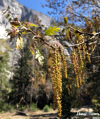
Dogwoods are what we are hunting for today. We are hoping that they are still vibrant and fresh. We get the first taste of them as we drive along Southside Drive. Looks like our hunting will be successful. We wheel into Camp Curry about 10:15. But we do not get boots onto the ground until after 10:30.

We walk up the road towards Happy Isles, Lots of dogwoods, which means that we stop every couple of yards and admire. Isn’t that why we came to Yosemite-well there are the falls and the walls and everything else.


Sherri and Jessi beside the Merced

When we get to the backpackers parking lot, we veer off to a trail which goes a bit south of the road, For being just a hundred yards away from the more traveled road, this trail is really quiet, I am concerned about this trail just because of all of the runoff and there is a section already swampy, I wonder how passable it is.

Suddenly an epiphany hits! I have left the GPS on top of the car. I told my companions to go ahead and I would meet them at Happy Isles. On the way back I wonder whom I can blame and the conclusion is that I only can blame myself. Sigh. Fortunately the GPS is still right where I left it.

I go up the road, rather than the trail,since it is slightly shorter and quicker. I probably went about 3/4 of a mile further than Sherri and Jessi. When I got there, there was no sign of them. But Sherri comes along and we meet up with Jessi. Lunch is the next topic. There is a little island-that stands to reason given the area’s name. We find a log and enjoy our lunch watching the Merced roar by.

Mirror Lake and Mt Watkins

We then start on our trek, crossing the Happy Isles Bridge. Here instead of following the Valley Loop Trail, we follow a trail which takes us along the Merced. This once paved trail is uneven with the constant water lapping against it season after season. Today it is dry and a joy to walk on. Like before we constantly stop and gawk. There is enough here for us to stay all afternoon.


Yosemite Falls
We are still energetic enough to climb the hill up to Mirror Lake. We see the other trail of the loop. Not for us today. Later on we find out that there are fallen trees across the trail and as I was suspecting, a bit wet. Jessi must be mesmerized by the trail because as slow as Sherri and I are, we can see her stopping often, finding the perfect way to shoot a flower, a tree or the walls of the Valley.

When we get to Mirror Lake, there is no reflection. But there is such a great view that I forgive it. Mt Watkins rises mid-canyon. Across from there is Ahwiyah Point. While not reflective, Tenaya Creek flowing through a full Mirror Lake makes the scene close to perfect.

Going to Yosemite Falls
When we leave the lake, Sherri and I get into a discussion with two couples. It can be a pleasure to exchange places with fellow backpackers about places where there is mutual connection. In this case, it was the Rae Lakes loop. Good to compare notes. I am afraid we have left Jessi to her own ways. But we find her waiting patiently a little ways further.


Horsetail Falls
We make a connection with a trail the horses use to get from the stables to Mirror Lake. I enjoy this section as few people actually walk it. Plus there are more flowers, more plants and, of course, dogwoods. Jessi asks if this will meet us at the road going up to Mirror Lake? I answer no, but am proven wrong. I usually continue on the Valley Loop to the Ahwahnee

 Today we head down the road to the Mirror Lake tram stop. Here, we pick up the Green bus which does the entire Valley. But we will get off at Yosemite Falls. It does hit the Ahwahnee. There the bus thins out and we can grab a seat. Who walks in? Several friends. Betty is the first one whom we recognize with her husband Randy. Theme there is John and Cathey, Rebecca and Keith, and a few others. It is always a good thing to meet friends unexpectedly.


Bridalveil Falls from Valley View


They get off before we do. Jessi, Sherri and I continue on to Yosemite Falls. It is running full, but with little wind. So the spray makes it down to the bridge over Yosemite Creek in small amounts. We hardly feel it. Our return trip gets us back to Yosemite Village. There we hunt out the suitable bus stop, number 2 if you really want to know. And then it is a long wait. Long enough that we all sit down on the ground to wait. After about 25 minutes, the Purple tram line comes and takes us back to Curry Village.

By this time, it is almost 6:30 and time to head home. But first, we stop at a turn out after Camp 4. Horsetail Falls is running nicely, but it is a bit late in the day, so the sun does not show off its splendor. But the Valley has one last parting gift for us. At the west end of the Valley is a popular turn out called Valley View. Today it shows us why it is so popular. With the deepening evening shadows, the sun draws lines of dark and light across the walls with Bridalveil just glistening there.

Fern Springs

Actually there was one more parting gift. We stopped by Fern Spring-Jessi, I had the wrong name. Black Spring is across the Valley from Fern Spring. Fern Spring is a quiet little pool of water which most people pass by. Today it is gushing. And now this is the way to leave the valley.

We get to Oakhurst about 8 and all of us are ready to eat. So we stop in at El Cids-the first time Sherri and I have been here in three or four years, The burritos hit the spot. In appreciation for the day, Jessi pays for our meals-she probably overpaid the tour guide in this regard as we enjoy Yosemite and would enjoy going up even without her. But with her, it just made it that much better. We get back to Fresno about 9:30. Poor Jessi has a bit more of a drive. I am tired but have enjoyed the day.


Background


Extra Photo's

Jessi and Gary on the trail

Merced River

Indian Canyon Falls

Stair Step Falls

Silver Strand Falls

Yosemite Valley from Tunnel View

Flower Child Gary
Yosemite Falls

El Capitan, Bridalveil Falls and the Merced from Valley View

Fern Spring

Fern Springs

Coyote seeking attention


Flowers and Plants


Dogwoods


Unknown


Sunday, July 14, 2013

July 14, 2013 - Bubbs Creek


Title: July 14, 2013 - Bubbs Creek

Hike Info:
Trail: John Muir Trail
Starting location:  Rae Lakes
Destination:  Upper part of trail to Forester Pass
Actual Destination:  About 10,600' on way to Forester
Distance:  9.3  1
Start Time:  7:20
End Time:   6:10
Travel Time: 10:50 ( mph)
Moving Time: 5:50 ( mph)
Elevation Rise:  2,420'  1
Maximum Elevation:   11,960'

Description:
Painted Lady
I must have been anxious about today. Woke up several times last night wondering if it was time to get up. Morning is bright and crisp blue sky with no wind. Sun is just starting to hit the Painted Lady.

At 7:20, we get a good start to going up to Glen Pass. Leaving behind the blue, inviting lakes we stayed by last night creates a longing to stay. But the steady climb of switchbacks are calling us. We start taking our breaks about every half of a mile. At our second break, we are passed by a group of young men, whom we label as the singing Boy Scouts, even though they are a little older than that. But they are going up this without breathing hard, nor stopping their singing. Amazing, since we are doing what we need to do to breath-even at rest.
Rae Lakes
 
Going up to Glen Pass, I am the weak link. Usually I am waiting for Sherri. But today, she is keeping up with me. She says that my breathing is a lot more gasping, that is for air, than usually. I am having more troubles with this pass than other higher ones, or ones which we have had to climb up more. It may be steeper, or maybe I am getting weaker. I do not know.

Range after range after range to the south
But once on top, we have such a scenic view of those tarns we have been looking at on the way up. Rae Lakes have popped back into view. As Sherri said, from this perspective, Rae Lakes just looks like another big tarn. She thinks the tarns look like alien lakes, maybe because of their deep blue-green colors, surrounded by all that rock. But you see them more like emeralds, even with their own islands. Their beauty does shine out, drawing you. But then your gaze looks across at where you came from. Range upon range of mountains. Some of which we traveled several days ago. The Palisades are there; Cardinal Mountain; and maybe even Mt Goddard. Then you look where to you are going and see this same series of mountains which we will need to cross. You wonder are we up to it?

Matt and Derek with Sherri
Also on top, are the singing Boy Scouts, which now that we see them, we wonder if they are Boy Scouts. They seem older, may be Explorers. But there is an older person with them. We have seen them lift off a balloon, maybe a weather balloon. They are from San Diego area. We got our Capture California picture for the hike with Matt and Derek.

Also Larry and Paul are up here, with three others who have made it to the top with us. It does seem a bit crowded with all of us on this narrow strip marking the difference between waters going to Woods Creek and Bubbs Creek. But nobody falls off, even though we are a bit leery of any sudden movements.

On top of Glen Pass
We start the descent down the south side of the pass, with me in the lead. Why? Because I seem to be the least concerned with the sheerness of the slope. This will seem funny to my brother as he is the one who is fearless in our family. But with I in the lead, Sherri following and Larry and Paul bringing up the rear, we make it down the trail safely.

At one of the stops, we find out that Larry is a Lutheran pastor while Paul teaches the electrical trades at a technical college in Green Bay.  We sort of walk with them, then lose them, only to regain them at lunch break at the junction with the Kearsarge Pass trail. Here we also eat lunch with three others whom we will get to know through the rest of the trip-George, Chris and Steve.

Bubb's Creek Valley
After lunch we continue down the sides of the valley which Bubbs Creek form. As we go down, we see the Videttes-both east and west. Seems like it takes awhile to get down this. But we are making it down farther than we did the Rae Loop a couple of years ago. When we get down to the floor, finally, we go a little ways, then take a break. Nothing fabulous, but refreshing.  Being intrepid, onward we go. Soon we see Paul and Larry, setting up camp. Sounds like they will be about a day or two behind us. So we say farewell and it has been good walking with them.

The Videttes


Center Peak
Up a ways, we start thinking about  where we wanted to stop for the night. It is a trade-off between getting some rest tonight and  setting up to tackle Forester Pass tomorrow. The higher up we go, the easier tomorrow will be. But we have about a 2,000' climb to get up to the highest feasible camp space. We are not going to be able to do this. So we pick a campsite around 10,000'. When we get there, there is a flock of tents, so on we go. The next stop is the creek which comes out of Center Basin. People are camped there, but being eagle-eyed, I think I see a spot above the creek on a ridge.  But when I pop my head over the ridge, there is a tent and a couple of men relaxing-we will see them tomorrow. So again onward we go. About a quarter mile up the trail, it cuts back and comes reasonably close to the creek. Plus there is a little draw where we can put a tent out of sight. It is a good place, better than the others we wanted to camp at. (36.73048, -118.37161)

What a glorious evening. There are still clouds in the sky, but looking down Bubbs Creek, the sun reflecting its golden rays. What a sight. Sherri and I are the only ones to collect this sight from a rock rock outcropping just outside of our camp.

Shortly afterwards we go to bed. It is getting colder. We watch half of Dr Who episode. I read, then go to sleep around 9:20.


 Breakfast Lunch Dinner Snacks
Oatmeal and add-ins, such as dried peaches, strawberries, nuts, granola. Tang. Peanut Butter and Nutella on crackers Beans with Tortillas Clif Bar, Jelly Bellies, CytoMax, Propel, GORP, Bank Balls


 1The supplied figures above come from either the book John Muir Trail: The essential guide to hiking America's most famous trail by Elizabeth Wenk or from topo maps. There was only partial tracks for today in my GPS. Below is the readings from today's status on the GPS. I view it as only somewhat accurate.
Distance: 9.50 miles
Elevation Rise:  1,566'
Maximum Elevation: 11,910'


Center Peak


Upper Rae Lake


Saturday, July 13, 2013

July 13, 2013 - Rae Lakes


Title: July 13, 2013 - Rae Lakes

Hike Info:
Trail: John Muir Trail
Starting location:  Woods Creek Crossing
Destination:  Rae Lakes
Distance:  6.8 miles 1
Start Time:  8:20
End Time:   3:30
Travel Time:  7:10 (0.95 mph)
Moving Time: 4:24 (1.55 mph)
Elevation Rise:    2,053'  1
Maximum Elevation: 10,600'

Description:
Looking back North
Even though this is a slow day, we will be rising up 2,000' in about 6 or 7 miles. This should give us a jump on Glen Pass tomorrow. In the meantime, Rae Lakes is the crown jewel of the JMT. So it will be a pleasure to spend time there.

The rise up is a continual rise, most of the time, nothing extreme. But not too terrible gentle either. The skies are clear, so in the morning this hike is pretty nice. We are in some forest and a bit of meadows, with a creek crossing or two.

Dollar Lake and Fin Dome
We meet up with a couple of groups doing the Rae Lake Loop. The first is a family of four formerly from the Ukraine. The kids are are 6 and 11. They looks like they are doing pretty good. Quiet, expected, full of inquisitiveness, and enjoying themselves. What a good education and training for them. The second is two friends from the Bay Area-Caroline and Lea. They are doing the JMT in segments. We seem to see one of them each time we stop.

Lower Rae Lake


Speaking of stopping, we stop at Dollar Lake for a leisurely lunch. Beautiful, peaceful lake. Looks like much of the camping is restricted from around the lake, but Sherri found a place or two up above the trail. This would be a good place to stay, if one is doing as the Loop on a slow schedule.

Mt Rixford and the Painted Lady
Each time we look back the place where we camped last night, it looks lower and lower. Of course, that says we get higher and higher. Just fantastic seeing this spread out behind us. As we look forward, we start to see Fin Dome, the Painted Lady and the rest of the mountains around us.

Middle Rae Lake


We got in around 4, or a little before (36.80294, -118.40273 ). Nice time to rest. We do see another piece of trail art. Is the message for us? From Ray and Rachel? We will need to ask them. I take a dip in Upper Rae Lake. Must have left a slick of trail dust on the lake-no longer, it no long is as pure as it once was. But it does feel oh so good. Then it is time to wash clothes. The wind helps to mostly dry them. Dinner is Spotted Dog.  We go to bed a bit early-before 8, mostly because it it getting cold, but the wind lets up. We decide to put the rain fly on to help keep warm.

Our Camp
For us?


Today's JMT Lesson:  O Lord, Our Lord, how majestic is your name in all the earth and heavens. Psalm 8


 Breakfast Lunch Dinner Snacks
Oatmeal and add-ins, such as dried peaches, strawberries, nuts, granola. Tang. Peanut Butter and Nutella on crackers Ranier Spotted Dog Clif Bar, Jelly Bellies, CytoMax, Propel, GORP, Bank Balls


 1The supplied figures above come from either the book John Muir Trail: The essential guide to hiking America's most famous trail by Elizabeth Wenk or from topo maps. There was only partial tracks for today in my GPS. Below is the readings from today's status on the GPS. I view it as only somewhat accurate.
Distance:  7.6 miles
Elevation Rise:  1,887'
Maximum Elevation: 10,600'