Showing posts with label Weaver Lake. Show all posts

Friday, November 8, 2024

November 8, 2024 - Delilah


Title: November 8, 2024 - Delilah Lookout
Hike Info : DescriptionExtra Photo's : Animals
Hike Info:
Type: Lookout

View of Delilah from the road in
Description:

We begin our last time at Delilah for the season. The schedule is for us to be here for three days. With a friend coming up Sunday and having dinner with us. But until then, we need to get up there. I am a bit concerned with the cold which we might face. I think I have enough clothes.

I got up at 0525 and got myself ready. Had my normal breakfast. Sherri gets up at 0600. I have the car loaded by 0700. But we do not leave until 0715. I am thinking we are running late, so I do not suggest a stop at Clingan’s Junction. The road to Delilah has improved during the past year. Instead of taking 45 minutes from getting off of 180, we make it in just over 30, About 0850. Then it is the usual, hauling stuff up, both on our back and through the pulley system.

At 0928 we go in-service to both Porterville and Sierra. About this time I see where Richard, who is the Delilah lead, says that with the storm coming in Monday, Delilah will close a day early. Now to figure out arrangements with our friend.

At 1000, Sierra catches me a bit off-guard. At 1100 they do their lookout check in, but I guess with shorter hours, it is 1000. But I recover fast enough and answer their call. Shortly after this, I hear Porterville trying to reach the Happy Fire IC. I offer to do a relay and they take me up on it. But after several call outs, I saw No Contact and told Portville this. A few minutes later, there is a faint call from the Happy IC, but I cannot get a response from him.

Haze from the Happy Fire


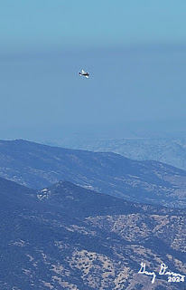
Mystery Plane
Shortly after this, I hear Patrol 33 is going for a walk up to Weaver Lake. There is a small fire going through up there. An hour later we hear that the Weaver Training IC and two of his co-workers are also going up there. A couple hours later, the IC is at Weaver and notes that the fire is about 0.1 acres from a campfire. They dug a ring around around the fire.

Back to the Happy Fire. The IC initiated a test fire. This is to see if the area they want to burn will do what they want. It was successful. So they proceeded with today’s burn just before 1500, we hear that today’s burn was completed and that about 155 acres were burnt.

Afternoon Happy Fire Smoke
On our side, it was just good to be up here. We did our lookout stuff. In addition, we were asked to count the visitors we have had this year. The grand total was 219, assuming none come up tomorrow, from countries like the Netherlands, Germany, Denmark, Iowa, Washington--well those last two are states, It is interesting that somebody will come half way around the world to get a view from this tower.


White Deer Road
 

While doing one of my scans, I hear a noise like a truck engine. I look around and do not see anything. But a little while later Sherri is doing her scan and is following a hawk. Then hears a sound like a helicopter. But when she points out where it is coming from, I see a very quiet plane. It leaves the area. But later on Sherri sees it again and it just goes over Pine Flat and turns back towards Reedley. Finally an hour later, I see it and it does the same thing. We are left wondering, what is it doing? My first impression was that it was helping with the Happy Fire. But after the other two patterns, it looks like it was either training somebody, mapping the area, or looking for marijuana plants. We will never know, so we are free to speculate.


Ravioli Dinner

Because of the shorter daylight time, we go out of service at 1530. Shortly afterwards, we go for a walk, down the hill Delilah is on. Normally we walk up the Delilah Road, but the
White Deer Road looks like it is available and we only have gone down this road once and only for a short way. It is westward facing, so it catches a bit more sun in the afternoon.The one disadvantage to this road is that it goes down. But we go down the road, descending maybe 300-400 feet. When it gets to the place where it rounds the ridge, it continues the descent. Sherri and I looked at each other and said we have had enough downhill. We return and get back to the cab around 1700.


We read and talk and read some more. I am looking at one of Sherri’s books, Francis Collins,
The Road to Wisdom. This is the optimal use of being alone, in the quiet of the lookout-to read, to think, to meditate, to pray. Unfortunately I am only good with the first. By the time I look up, it is dark. I have missed that moment of transition between day and night, that time which the setting sun exits. But we still have the moon.

Around 1800, Sherri fixed us the ravioli we were going to have Sunday with Judy. Tastes good. It is leisurely. Usually dinner at Delilah is looking out over the fading sunlight. This is darkness, a bit more intimate. We just enjoy each other’s company.


 Down to the outhouse we go, then lock ourselves in. Even with the moon shining pretty good, we enjoy a bit of stargazing. Then around 2100, we turned in.


Extra Photo's


Star over Fresno

Autumn Leaves

Fence Meadow Lookout

Autumn Leaves

Animal
Outhouse Spider

Monday, August 26, 2024

August 26, 2024 - Weaver Lake from Fox Meadow Trailhead


Title: August 26, 2024 - Weaver Lake from Fox Meadow Trailhead
Hike Info : Description : Extra Photo's : Flowers and Plants

Hike Info:

Type: Hiking

Trail head: Fox Meadow Trailhead

Trail: Weaver Lake

Destination:  Weaver Lake

Distance:  4.12 miles 

Start Time: 11:26

End Time:    4:00

Travel Time: 4:34  (0.90 mph)

Moving Time: 2:38   (1.56 mph)

Elevation Rise:  905'

Descent: 905‘

Maximum Elevation: 8,756'

GPS Tracks


Description:

I got up at 5:30 and noted that there was no lightning to report. Then I spent the next couple of hours doing a few misc things. Such as there seems to be an issue when a person sends an email with an attachment to an AT&T address, such as when the Buck Rock people do that. So I spent half an hour explaining the issue. AT&T support then elevated the issue and said that I would hear back from them.

We also went to the church and dropped off some gift cards. And this was the root of a conflict this morning. One interpretation was that I was to drop off the cards and return; the other was that we would drop off the cards on the way to the trailhead. We ended up doing the latter, about 9:30, an hour later than anticipated. Which was the right interpretation? We will never know.

I drove on the way up and there were no real issues except for an occasional slow driver. When we entered the Park, I asked the ranger about our entry Friday. His reply was to come in early as it would be the start of the Labor Day weekend. We continue on towards Big Meadows, stopping at the snow trailhead for use of the bathroom.


Sherri almost to lake
Usually we will start at the Big Meadows Trailhead, but there is a second one at Fox Meadow. This is both a bit higher and takes off about a mile and a half from the trail. Given our late start, we opt for Fox Meadow. The one drawback of Fox Meadow, besides the fact we shortchanged ourselves of some of the trail, is the road. The road is 14S16 which gives you the idea it is a Forest Service road and non-paved. It is a bit rocky and rutted from some runoff. So we get jostled around, but nothing more than our Highlander is OK with.


Steven's Hammock

Gary Resting

Our boots touch the ground at 11:30.It is a short couple hundred yards walk till we meet the trail to Weaver Lake. This is a trail we have been on many a time. So the trail is not new to us. Last time we were on this trail, it was 112 in the Valley and very hot up here. We stopped at the creek which feeds Fox Meadow for lunch around noon. This is the same creek last time Sherri stopped here and thought it best not to go on. But today we all go on.

After our 12:00 lunch, we continue on. There is a good exposed rise out of this creek. But once we complete this rise, it is more rolling over ridges and down to creeks. Steven and Korra have gone ahead. When Sherri and I get to Weaver Lake, about 1:30, Steven has already set up a hammock and is wading in the lake. Korra does not seem as sure about going out into the water, but eventually does join Steven.

Sherri and Gary
Sherri and I stay on land and enjoy the beauty of the lake. Being in the shade is a bit cool with the breeze blowing through. But when in the sun, it is warm with the ultraviolet rays being able to penetrate in the sun.

We must have been a bit tired as we just enjoyed the rest for an hour. At 2:30, we start our trip back. Going down the hill is a lot easier than the inbound trip. Sherri and I leave a few minutes before Steven, but he quickly catches up and passes us, getting to the car before us. Sherri and I arrive at 4.

Steven drives us back to Fresno, That road down from the trailhead, the one I took my time, Steven makes it look easy, and it certainly seemed quicker with him driving. Once in Fresno, we get cleaned up and then go to Red Robin for dinner. By the time we finished, we all felt content.


Extra Photo's


Sherri passing by Fox Meadow

Steven in Weaver Lake

Weaver Lake

Korra on Watch

Squirrel Alert

Sherri and Steven on way back to car

Fox Meadow


Flowers and Plants


Fireweed


Tuesday, March 12, 2024

March 12, 2024 - Big Meadows Snowshoe


Title: March 12, 2024 - Big Meadows Snowshoe


Hike Info : Description : Extra Photo's 


Hike Info:

Type: Snowshoeing

Trail head: Big Meadows Winter Trailhead

Trail: Big Meadows Road

Destination: Big Meadows

Distance:  4.90 miles 1

Start Time: 12:33

End Time:    4:12

Travel Time: 3:38  (1.35 mph)

Moving Time:  2:39  (1.85 mph)

Elevation Rise:  586'

Descent: 545‘

Maximum Elevation: 7,827'

GPS Tracks

 1There seems to be some discrepancies between this figure and some signposts. A sign says 2¼ miles to Highway 180 from Big Meadows and the trailhead is about a quarter mile from the highway. So we should have gone a total of 4 miles. Also Steven’s Strava is less than five miles and he went all the way to the main Big Meadows Trailhead for Weaver Lake.


Description:

The Mist of being in a cloud
Depending on the weather, today may be the last day we will be able to go up and play in the snow. The reason? First, Sherri and I are going to visit Andrea for a two week trip. Next, the promised snow in the mountains has been less than exciting. As a clue, today the snow was maybe 2-3’ deep at 7,000’. With daily temps being in to 40-55 degrees, that snow will not last long.

I slept in a bit until 7:30, of course last weekend I lost an hour, so this is really 6:30. Sherri has a doctor’s appointment, so we will leave after she gets back. She gets back home around 10, we load the car and leave around 10:45. Even though the drive is uneventful, I am eyeballing the continuous layer of gray clouds stretching in front of us. We travel through a layer of clouds and end up at the entrance station by Grant Grove.

Burnt Trees from the Rabbit Fire

Sherri on the Big Meadow Road
  We, or should I say I, talk with the entrance station lady, Jessica. I think she must not have been very busy today as we gabbed for five minutes. But that is not why we traveled up here. We moved on and get to Big Meadows around noon. Our first order of action when we get there is to eat lunch. Then get our gear together and are off.

Steven got a five minute head start-even though being on skis he did not need any advantage. Sherri and I take off at 12:45. The road is freshly groomed with only Steven’s ski tracks, Korra’s paw prints and a snowmobile print. The sky is cloudy with only an occasional peeping out of blue and even less of the sun. At times a mist floats by-wwe must be in a cloud. Even though when we left the car said we were in the 42-44 degree range, it was a cold temperature. I have my warmer gloves on.


Sherri and I make our way along the road, doing pretty decently. About every third of a mile we take a break to breathe, we are at 7,500’ after all. Really not much to see except for the gray of the clouds and the trees lining the road.

At the junction with the Rabbit Meadow road, we decide to just go on to Big Meadow, following Steven’s tracks. We start to see signs of the Rabbit Fire from last year. This was a lightning cause fire which the Forest Services decided to manage to burn some of the excess duff, so they needed the fire into areas which they wanted burnt. But there are stands of burnt trees which must have been in the path of the fire before it was brought under control. In the distance I have been hearing a bird chirp, but I could not see it. It is a reminder that even in a dead forest, there is still life.


Shortly afterwards, we see the warming hut at Big Meadows. It is the end of the line for Sherri and I. Steven’s tracks go further on. But not for long as we see a snow cat coming down. When they stop at the hut and start unloading, I know who one of the people is, Dutch. He is a recipient of my lightning report and I see many of his pictures though Wendy. I introduce myself and we talk for a few minutes and then rejoin Sherri.

Redwood Canyon in the clouds

We got to the hut right at our turn around time of 2:15. Steven comes back, with Korra. We compare our mileages. I have 2.6 miles, Steven has less even though he has traveled at least a mile and more like a mile and a half further. There is a sign saying the highway is 2¼ miles away. A continuation of the discussion from last Friday.


Big Meadows Road


And we all start our return journey. Steven and Korraa quickly are out of sight, followed by Dutch and his friend on a snowmobile. While the clouds are not getting less, there are breaks in them which allows us to see windows into the surrounding mountains. This is an awesome view. Clouds have that way with me. Not sure if it is because they hide and reveal, similar to how God is hidden, but gets revealed.

About halfway back I can start to feel that I have not gone this far on snowshoes this season. Another way to say that I am starting to tire. But maybe it is the uphill which I am going up-not a long one. Once we get back to the Rabbit Meadow junction, I start to feel a bit rejuvenated. Maybe because it is downhill from here? Or maybe it is like a nag who can smell the oats in the barn ahead.

We make it back to the car at 4:10 with Steven and Korra waiting for us. When I sit down to take off my boots, I can feel how tired I am. Steven is driving back-I am grateful for this. We stopped at the overlook at Redwood Canyon. I am tired enough that I left Sherri and Steven to snap their pictures while I sti in the car. We decided that Bear Mountain Pizza is a good place to get refreshed. We make it home by 6:15. I promptly lay down for half an hour-feels sooo good.


Extra Photo's


Gary going down the Big Meadow Road

Big Meadows under snow

Shell Mountain

Gary starting off

Gary

Clouds hiding a mountain

Sherri on the way back

Burnt trees on Big Baldy from the KNP Complex

Redwood Canyon

Redwood Mountain

Steven