Showing posts with label Brewer. Show all posts

Wednesday, October 9, 2024

October 9, 2024 – Park Ridge Lookout


 Title:  October 9, 2024 – Park Ridge Lookout

Hike Info:
Type: Lookout
Park Ridge Guards
 

Description:

Woke up shortly after 5. I had done the lightning report last night, but just checked to see if there was activity between then and now-there was none. So I spent a leisurely time getting ready to my day at Park Ridge Lookout.

Plume from the Happy Fire
I take off a few minutes before 7. And it is a pretty easy drive up to the Park. I had noticed a smoke smell about 3,000’. When I got to the Park entrance, I asked the entry station if he knew where the smoke was coming from. Jeff said the Happy Fire. There was growth last night. Good to know.

As I was climbing up toward Panoramic Point, I started to notice a different smell. Not sure what it is. But when I stopped to unlock the gate to the service road, I knew what it was: coolant from my Ranger. Looking inside, I saw that a connection to a hose had broken. There is no cell service here, so do I go on to the Lookout or try to go back down? I decided that if the hose could be kept in place, there should be some duct tape at the Lookout which would help me patch together things. Plus there is water there. I put a quart of water in the radiator and was able to get to the lookout. The hose had gotten detached. I got some duct tape out of the cab and made an attempt to hold the hose in. I will do a better job of it later.


Inversion Layer in the north

I open up the lookout, bringing my stuff up. Only two loads which is a lot less than the number of times I go up for multiple days. I then take the weather, look at the boards and do a scan.

Smoke to the south
I should have known that today would be one of those days. I try to go in-service with Porterville. But Buck Rock walks over me. So I go in-service with Ash Mountain Fire. Then attempt to do it with Porterville. No response. On the fourth time, I get a response and go in-service.

Then it is the normal stuff. Scanning, listening to the radio. I get two visitors from Minnesota and I go through my fir and prescribed burn routine. they are interested in lookout life. Also he seems fascinated with the Osborne Fire Finder. That breaks up the day some. There is a lot of haze/smoke. So I only have about 5 miles of visibility. The smoke is from the Happy Fire. I heard on the radio that there are a couple of our folks up at the fire, tending it. Around 1145 they will be leaving the fire. Their call sign is Firewatch51. As I am hearing them, I think we need a cool call sign instead of Park Ridge Lookout or Delilah.


I talked with the President of the
Buck Rock Foundation. I told her Sherri and I were resigning from being Associate Directors on the Foundations Board. We are not unhappy with the Foundation. We just think that we have one too many things going on and this will be easiest to cut. We still want to be lookouts.

Looking east, pretty clear

By 1230 it is time for lunch and I take care of that. Then followed at 1315 for the weather. It looks like the smoke is lifting some. Towards the west, I can see about 6-7 miles along with the south. But the real improvement is to the east where I can see Mitchell Peak very clearly now along with the peaks behind, such as North and South Guard and Mt Brewer. I spend a few minutes laying down with my 15 minute timer going. A bit more rested. More scans and going over the terrain.

About 1430 I think I should go down, and revamp my fix to the radiator hose. I set up the Forest’s handheld to scan SQF’s Ch 4, R5 Project and the Park’s Command 2. Almost immediately I heard communications on the handheld from the Park, but none on the Park radio. This is interesting. After I go down and do what I am going to do, I will check this out further.

Looking at the tape job I did this morning, I think there is a better way, so I redo it and fill up all of the coolant water places. Then it back upstairs to figure out the radio.

I confirm that the Park radio seems to die after a couple of minutes. But it had been on the charger all night. Maybe the charger is not charging? Or have all the batteries decided to die? Or maybe it is the radio? At this point, I think it is time to bring in Wendy. I explain about the radio and she said that the lady who was up there previously was having issues as well. We work through a few things to no avail. Wendy suggests the clam-shell. There is a clam-shell filled with AA batteries. The outside contacts has a layer of corrosion which I wipe off. Still no good. I cannot open the clam-shell to see if the batteries are corroded as well. I tell Wendy that I think I can work with the Forest radio and she said to change the tone to 7 so I could talk on it. After some fumbling, I am able to. Set the tone and do a radio check with Ash Mountain Fire. They are able to hear me.

Source of my car problems
I then explain to Wendy that I had car problems coming up.. She is ready to call in the cavary. I think if I can make it to Panoramic Point, I can get down to the Visitor center pretty easily. It will be a lot easier to get help there. But she advocates that I leave early. Now that sounds pretty good. It is about a quarter to four. There is a few things to do before closing up the lookout. I only manage to leave at 1630, about 25 minutes sooner than scheduled.

I notified everybody that I was leaving. I keep an eye on the temperature gauge. It looked pretty good. I get to the gate and start down the hill, a bit nervous, but pretty confident I will get to the Visitor Center. I do get there and I tell Wendy, Sherri and Steven of my status and continue on my way. I do pretty well until just past Bear Mountain Pizza when the Ranger starts to lose power. I stopped by the side of the road and there is steam coming out. I guess my fix did not last all the way down. I have about three gallons of water which I put into the radiator after letting the engine cool a bit. Then I am off.

This time I make it as far as Centerville. I debate about getting a tow or having Sherri come out with water. I decided to inconvenience her. About 45 minutes later she comes out with four gallons. I fill the radiator and am off. I am hoping to make it home. But not quite. I make it onto Dakota, about three miles from my house. I try to park at a spot which will allow access for Sherri, but not be blocking anybody. I failed. The Ranger dies in the middle of a alley access to a gym. But some SouthEast Asians, tell me to get back in the vehicle and they push me to the side of the road. Thank You!

Sherri comes out in about 30 minutes-she had not made it home yet. I will the radiator and make it home after 2000. After unloading the truck, I join the Zoom family meeting. It is good and relaxing. Sherri makes me a croissant chicken sandwich. It hits the spot. After the meeting, I take a shower and go to bed-I am tired.

The next day, I take the truck into Snapps. They are able to get the part and having it back to me in one day. I love that place.


Trail Lesson: Things will happen, be prepared for them.

Tuesday, November 21, 2023

November 21, 2023 - Pincushion


Title:  November 21, 2023 - Pincushion
Hike Info : Description : Extra Photo's : Animals


Hike Info:

Type: Hiking

Trail head: Finegold Area 

Trail:  San Joaquin River Trail, Pincushion Trail

Destination:  Pincushion

Actual Destination: Above a hundred yards from the top and 150 feet below.

Distance:  2.62 miles


Start Time: 11:43

End Time:    2:58

Travel Time: 3:15  (0.81 mph)

Moving Time:  2:21  (1.12 mph)

Elevation Rise:  1,045'

Descent: 1033‘

Maximum Elevation: 1.492'

GPS Tracks


Description:

Sherri on path, climbing
What are we going to do today? Confession: I slept past 7 this morning. It was not until Sherri was getting her breakfast ready did we agree upon a hike: Pincushion. Pincushion is a local peak near Millerton Lake.

Sherri and I started from our house a little after 10. Table Mountain Casino has expanded since the last time I was here-I had a bit of trouble finding the right road to go up. So it took me a few tries to find Sky Harbor. Even with the detour, we got to the Finegold area of Millerton State Park by 11:15. The gate was closed-we would not be going in anyway as we have not bought a pass. But we did find a place to park on Sky Harbor.


Yes, it was that steep

By the time we started walking it was 11:45. It was less than a quarter mile into the trailhead and outhouse. The trail starts off by going up a pretty good slope. Having been on this trail several times, this is not unexpected. Sherri is keeping up a steady pace; I am doing OK, but I can tell that we are ascending. After traveling ¾ of a mile, Sherri comes across three people who wonder how much further it is to Pincushion? We say they are about a third of the way there, but the majority of the climb is ahead. This suitably discourages them.

50 yards further, the trail to Pincushion splits off of the San Joaquin River Trail. Actually, the real trail is about a quarter mile further, but this is the one commonly used. Now the climb really starts. The trail is badly rutted. It is wide, so it is possible to avoid the worst of the issues. No matter how you work it, this is steep-overall about a thousand feet in just a bit over a mile.


Gary having climbed up rocks


As we work our way up the slope, it just gets steeper. It is not because my legs and lungs are getting a workout that I think this, but just looking up the trail, it is steeper! But taking it one step at a time gets us up the hill.

There is a shelf about 150’ below the top of Pincushion. This is a bit of a rocky area which we climb up. I feel a bit uncertain about going to the top-maybe it is old age, a bit of arthritis, or just the legs feel out of shape. Whatever it is, I am content with stopping on this shelf and looking out over the area. I do not think it took too much to convince Sherri to stay here either.

From the log we are sitting on, we can see Spanish Mountain, Mt Brewer, Mitchell Peak and a whole bunch of other mountains we can see from our lookouts. Always interesting getting a different perspective. We also have lunch here while we enjoy the sight and sun. It has been a perfect day weather-wise. Sherri gets a call from Verizon-Rachel is trying to add a connection to the account and Verizon needs Sherri’s permission, which is given.


Peaks seen from Pincushion from the PeakFinder application


Sherri descending
And now we start back down. I think that old thing makes me more conscious that if I fall, I will break something and it will take a long while to mend. So I pick my way down carefully-even dragging my rear on occasion. Once we get down so we can walk, it is just a long steep downhill where we pick our route carefully-remember the old remark.


Not much is different on the return trip, except it is a lot easier on the lungs. We made it back to the car by 3:00pm. It has been a good hike, even if it has left me a bit rubber legged. It is one which I need to do to rebuild strength.

One thing I do when we get back home is to look up getting a State Park Pass for Seniors and 2024. Looks like I can apply only after Thanksgiving. Time to put that on the calendar.


Extra Photo's


Millerton

Tree and Sun Glow

Sherri coming down rocky section

Spanish Mountain

Scene from Pincushion

Animals


West Coast Lady

Ant Hole

Saturday, October 8, 2022

October 8, 2022 - Park Ridge Lookout

 Title: October 8, 2022 - Park Ridge Lookout

Hike Info:
Type:Lookout


Description:

Sherri and French Toast

It was already light when I rolled out of my sleeping bag at 0720. This is really late for me. Still I have read for a few minutes before getting up and checked for lightning-knowing there is not any. Sherri gets out of bed a few minutes later. My mattress has held up and I have gotten a good night sleep here at Park Ridge.

We go for a short walk down the road, just to stretch our legs. When we return, Sherri starts off the day by making French toast. What a treat to eat like this in the lookout. By this time, we take the weather and go into service at 0928-Buck Rock has beat us by a minute.


Morning Haze and Smoke

There is some radio activity, not involving us. We are just passive observers, going and doing what our volunteer position requires of us. That is to do our scans, observe the weather and listen to the radio. With two of us, it gives us an opportunity to relax a bit while the other concentrates. Now I am not saying that we do not get our entertainment. How the clouds are working, they highlight the mountains to the east. Mountains like
North Guard and Mt Brewer. It is worth being up here just for these moments.


Rare Double Sun earth sighting


By 1800, we go out of service for the evening. Time for dinner, read for a bit. The sun goes down by 1830, so it does not give us much time to do anything, except admire the view we have. But the good part of this is that the moon is almost full and Jupiter seems to be riding along with the moon. I am trying my new found skill of taking night pictures. Some of them even come out good. By 2000 we are ready to call it a night.


Extra Photo's


Moon, Jupiter and Clouds

Moon, Jupiter and Clouds

Moon, Jupiter and Clouds

Animals


White Headed Woodpecker

Soaring Hawk about a mile away

Friday, January 2, 1970

Places: CA-Brewer


Mt Brewer-13,497' (Mount Brewer)   (36.7085481, -118.4853741) 
Legal: T__S, R__E, Sec__


Deg Min Vertical Deg Min Distance Visible
Delilah
100
30
3
33
35.7

Somewhat
Park Ridge
92
24
3
33
25.5
Yes
Buck Rock
95
24
3
37
20.9


Brewer Lake-8,747' (Dogtooth Peak)   (37.1667288, -119.1231608)
Legal: T__S, R__E, Sec__


Deg Min Vertical Deg Min Distance Visible
Delilah
359
27
2
33
25.1
No
Park Ridge
342
6
1
25
32.2
No
Buck Rock
334
3
1
5
33.1


Big Brewer Lake-10,955' (Sphinx Lakes)   (36.7020204, -118.5098495) 
Legal: T__S, R__E, Sec__


Deg Min Vertical Deg Min Distance Visible
Delilah
101
39
2
50
34.5
No
Park Ridge
93
35
2
33
24.1
No
Buck Rock
97
3
2
22
19.6


Brewer Creek-7,966' (Sphinx Lakes)   (36.6999389, -118.5606527)
Legal: T__S, R__E, Sec__


Deg Min Vertical Deg Min Distance Visible
Delilah
102
57
1
58
31.8
No
Park Ridge
94
28
1
14
21.3
No
Buck Rock
98
45
0
40
16.9


From Up and Down California by William Brewer     
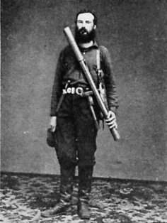
William H. Brewer
Description:

Brewer Creek:   We were working back toward high peaks, where we hoped to discover the sources of Kings, Kaweah, and Kern rivers, geographical problems of some considerable interest and importance. We got back as far as we could and camped at an altitude of 9,750 feet, by a rushing stream, but with poor feed. Wood was plenty, dry, from trees broken by avalanches in winter. A beautiful little lake was near us.6  About five miles east lay the high granite cone we hoped to reach—high and sharp, its sides bristling with sharp pinnacles.  From Up and Down California by William Brewer, Book 5  Chapter 2


From Up and Down California by William Brewer     
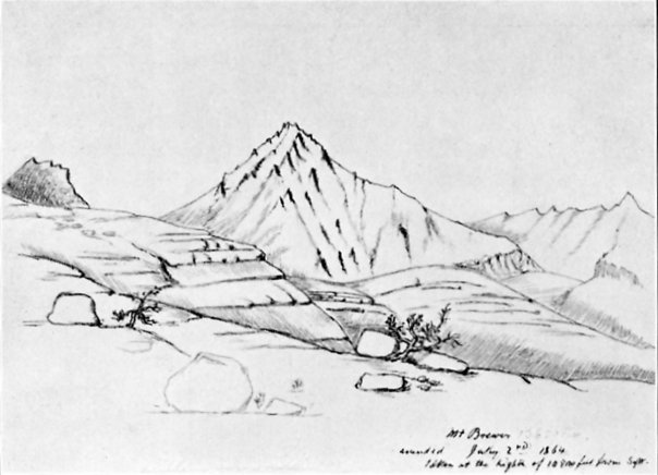
MOUNT BREWER
From a sketch by Charles F. Hoffmann
Mt Brewer:   First ascent of peak:   Saturday, July 2, we were up at dawn, and Hoffmann and I climbed this cone, which I had believed to be the highest of this part of the Sierra. We had a rough time, made two unsuccessful attempts to reach the summit, climbing up terribly steep rocks, and at last, after eight hours of very hard climbing, reached the top.   From Up and Down California by William Brewer, Book 5  Chapter 2

From GNIS:
  • East Creek: at one point was called Brewer Creek: Browning, Peter. Place Names of the Sierra Nevada. Berkeley, California: Wilderness Press, 1986. p61
  • East Lake: at one point was called Brewer Lake: Browning, Peter. Place Names of the Sierra Nevada. Berkeley, California: Wilderness Press, 1986. p61


Trips:


References:
  •  
Pictures: