Showing posts with label Mt. Whitney. Show all posts

Thursday, February 20, 2025

February 20, 2025 - Car Fixed and Return to Fresno


Title: February 20, 2025 - Car Fixed and Return to Fresno
Hike Info : Description : Trail Lessons : Menu : Extra Photo's : Animals 
Hike Info:
Type:Car


Borax Museum
Description:

Wow! Last night we had a couple wind events. Both Sherri and I woke up to things flying off of the table. But Sherri got ready first and secured things. Then a few more things were banging around and she went out again. This time it was the neighbors stuff which was flying. The wind was strong enough that I felt the floor of our tent lift up a bit, even with my body on it. In case you cannot tell, Sherri is the hero of this story.

Once things settled down we both fell asleep. I got up at 6:30 and walked our campground, talking with a couple from New York. This is their first time in Death Valley. When I plop down in my camp chair, Don comes walking up. Sherri gets up shortly afterwards.

This is our cue for getting breakfast going. It is a repeat of Tuesday mornings: French Toast and Turkey Sausage. Sherri makes the batter and I cook this morning. It feels good to have a spatula in my hand.

By 9, Steve has not shown up, so Don goes for a walk. Shortly afterwards, Steve shows up and starts to work on getting the car put back together again. We talk and he thinks he can get it together in a couple of hours. That would be great If that happens, then we will get camp broken and be able to go by noon.

 Sherri and Don make lunch and get the food put away. I start to clear out the car and get things organized to go if it happens. Don had visited the Borax Museum at the Ranch area, so the two of them went down, while I babysat the situation and did some preparation for a possible departure.


Don shoting the Palette


I do not get much done between talking with the two Dave’s-our jumper friend and the campground host. Then Jim and Joe, our neighbors. I tell them all that it looks like things will get fixed and we are planning on leaving. I enjoyed talking with all of them.

By 11, Steve is putting the finishing touches on the car. I got some water for him, about a gallon, so he can top off the radiator. Then we start up the car and it works! I am amazed and thankful. We let it run for a few minutes and I start to break down the camp. Steve wants me to take the car down to the shop to put some coolant in. I meet Don and Sherri on the way up and let them know. Steve takes the car for a ten minute test drive and it passes. We are good to go!

When I get back to camp, Sherri and Don have gotten much of the camp broken down. I finished up on a few things. 

One thing which we decided to leave out was a scorpion. It was under the ground cloth of our tent. Don saw it before it decided to seek shade someplace else.

We have the car packed and ready to go by noon. So we say goodbye to our campsite and head out.

But let's get one thing seen in Death Valley. We choose Artist Palette. This is about ten miles south of us. We quickly drive, within the speed limit, to the entrance. Artist Drive is a one way road. At the southern end, there is a women’s bicycle tour group. Sherri gives them a thumb’s up.

Rainbow Canyon

Don is suitably impressed by the terrain and with where Sherri and I have walked before. And we had not gotten to the Palette portion yet. When we do, Don goes and gets a closer view of the colorations. We stay at the parking area and talk with a couple of the women cyclists. When Don comes back, he is really jazzed by the assortment of colors. He starts spouting off about what makes the various colors. It is always good to see someone who is energized by the beauty of what they are seeing.

It is now time for us to start back to Fresno. We go through Furnace Creek and Stovepipe Wells. The car is holding up nicely. When we get to Panamint Springs, I decide to put five more gallons of gas into the tank, just in case, even though I think we would be able to make it to Bakersfield on this tank, but why chance it?

About 20 minutes later we get to Father Crowley’s Point. Here we have lunch before we continue on. But we were able to look into Rainbow Canyon. I do not really see the rainbow colors, but Don sees it. A couple asks us if any jets have come through? Not in the 20 minutes we have been here, but they did see a jet earlier on a practice run.

I am back in the driver's seat and we continue on our way. After leaving the Park, we go through some valleys where we see some small Joshua Trees. Then we break over a small hill and the peaks of the high Sierra Nevada start to show through. We are trying to pick out Whitney, but not sure that we are. That is until we got to a sign close to Owens Lake which pointed out where Whitney was.

 At that stop, Sherri takes over driving. She guides us down 395 to 14 and into Tehachapi. There we stopped at Chipotle for dinner. It has been awhile since we have been there. Evidently it is Don’s favorite place. We come out of there full and content.

I drive down to Bakersfield and get filled up with gas at Costco. Then it is up 99 to Fresno. Thankfully this trip home is uneventful. Shortly before 9, we let Don off at his house, unloading his stuff. Here we do notice one causality from the trip. A syrup bottle must have tipped over and Don’s tent now has a certain sweetness to it. Then it is another three minutes to our house. We decided to just leave everything packed in the car until morning.

While the trip was shorter than anticipated, it certainly felt longer. I am also glad that if the car was to suffer a breakdown, it was where it did and not in the middle of the desert. Just feel gratitude that we were being watched over.

Places we planned on, but could not do:

ubehebe crater

old stovepipe wells

mesquite dunes


Trail LessonGratitude is the response I should have at the end of each trip


Menu

Breakfast

Lunch

Dinner

Snacks

French Toast/Turkey Sausage/syrup/jam

PB&Nutella or jelly Sandwich

Chipotle in Tehachapi

Clif Bar, GORP, Propel, CytoMax, Scratch, Coffee Candy, Jelly Belly


Extra Photo's


View of the Sierra

The Road

View to the south of Father Crowley Overlook

View to the east of Father Crowley Overlook

Rainbow Canyon

Wash close to Artist Palette

Don climbing up for a better look

Artist Palette

Borax Museum

Animals
Scorpion

Scorpion

Friday, August 30, 2024

August 30, 2024 - Park Ridge Lookout and Hike


Title: August 30, 2024 - Park Ridge Lookout and Hike
Hike Info : Description : Extra Photo's : Flowers and Plants
Hike Info:

Type: Hiking : Lookout

Trail head:  Big Stump Parking Lot

Trail: Book Stump Loop

Destination:  Loop

Distance:  1.74 miles

Start Time: 1:23

End Time:  2:59

Travel Time: 1:35  (1.10 mph)

Moving Time: 1:01   (1.69 mph)

Elevation Rise:  308'

Descent: 289‘

Maximum Elevation: 6,397'

GPS Tracks


Sherri on the trail

Description:

Got up at 0600, probably because I am used to getting up at this time. Last night we got home after 2200 from the theater. The Second Space group put on Our Town and our House Church went to it, including dinner at Cucas. This is a bit late for me, but that is fine. Also Steve from Cambria came over to join us and is staying with us. With all of that I went to bed a bit late.

After I got up, I finished up my notes on John Mark Comer’s book Practicing the Way. It is both a pretty basic book, but one which is a good reminder about what it means to follow Jesus. By the time 0900 rolls around, all of us are up and we head to the Train Depot for breakfast. Satisfying, like always. Enough so, that lunch was not needed on my part. When we get back home, Sherri finishes packing.

Gary on the trail

We are able to leave by 1130. The drive is not bad and we make good time, getting to the Park entrance around 1300. The ranger recognizes the Buck Rock Foundation magnetic sign on the side of the car and waves us through, after we talk for a few minutes. It is great to be recognized like that.


A determined Sherri
We had not decided on what hike to do. But when we stopped at Big Stump, we decided that the two mile loop is good. So down the trail we went. We shortly met a fellow volunteer, V37, who shooed some hikers off of a trail which is being worked on. Then we had a bit of a discussion about various places and the smoke. We each continue on our way, rounding the meadow and going on the featherbed trail. When we get to the Mark Twain Tree , we break for lunch. Sherri actually has lunch, I have a few bites of my GORP. Then onward we go. After crossing the road into the Park, we continued on, at an easy clip. We are maybe a third of a mile from the car, when we see someone stopping a little ways in front of us. When we met him we talked for a bit. His parents are campground hosts at Stoney Creek and he is staying with them. We talked about various places to go to. Sunday they are going to the Buck Rock Open House. Yea!


It is not much further back to the car. We decided to go to the visitor center and look around for a few minutes. On the way into the Visitor Center, we see some people in blue T-Shirts saying Trans-Sierra

Gary, caught in a time warp
. I recognize this as a group which a friend of ours from church started to bring the outdoor experience to his elementary students. Now one of his people is carrying on. Turns out that Chris is in the group and Mike will be picking them up when they complete their trip going over Whitney. Small world. Chris recognizes my name as we have connected with him via email.

 Into the visitor center we go. Sherri to browse their selection, and I to ask about the Dark Sky Event in a week. They do not have much on the Dark Sky event, except what is on the website. But they are also trying to help some people trying to get to Eshom. I suggest a route, of course, I cannot help myself. After the Visitor Center we went and bought an ice cream bar and split it.


Then it is on the road up towards Panoramic Point. We take the service road over to Park Ridge. We got there about 1620. Nancy has an early morning date at Buck Rock, so she is happy to leave early. Her friend, John from Maryland, sticks around and we talk for a good half an hour about various things.

CoffeePot Fire as seen from Park Ridge Lookout

 Once he leaves, we start hauling stuff up for our three night stay. That is food and water and bags and mats and clothing and our playthings (i.e., computer). Once we get settled in, it is time to do the scans and listen to the radio and keep the logs. At 1750, we went out of service with Ash Mountain Fire. But we will be in service until 2000 with Porterville.


Smoke to the west of Park Ridge Lookout

As the evening progresses, the sun gives a display in the clouds. Also the CoffeePot fire smoke becomes more defined and looking immense. After about 1930, it really is too dark to see smoke from unwanted fires, so I switch over to trying to see if there is any red light which might indicate fire. When I looked towards the south, there definitely was red, a lot of red. We can see the flames and glow from the CoffeePot Fire and it appears to be much larger than I thought. We are looking at it from 20+ miles away and it is big.


At 2000, we go out of service and Buck Rock does the same right after us. It takes a little while for us to get situated. So it is after 2130 before we get into our bags and turn off the light.


 Extra Photo's

Afternoon smoke from CoffeePot Fire

More smoke from CoffeePot Fire

Panorama of the smoke spread

Smoke and Hills

Sherri's selfie

More smoke and hills to the south


Flowers and Plants


Checker Bloom

Chinquapin

Indian Paintbrush

Alpine Aster

Monday, November 15, 2021

November 15, 2021 -Death Valley: Desolation Canyon, Zabristkie Point and Dante Point


Car Route

Title: November 15, 2021 -Death Valley: Desolation Canyon, Zabristkie Point and Dante Point
Hike Info : Description : Background : Extra Photo'


Hike Info:
Type: Hiking
Trail head:  Desolation Canyon
Trail: Desolation Canyon
Destination:  End of Trail
Actual Destination:  8’ dry waterfall about a mile in

Distance:  2.01 miles
Start Time:  9:36
End Time:   11:44
Travel Time:  2:08 (0.94 mph)
Moving Time:  1:01  (1.98 mph)
Elevation Rise:  285'
Descent: 315‘
Maximum Elevation: 289'

  Hike Info: 
Type: Hiking
Trail head:  Dante Peak
Trail: Dante Peak/ Mount Perry Peak
Destination: Dante Peak
Actual Destination:  an overlook
Distance: 0.49 miles
Start Time: 3:02
End Time:  3:45
Travel Time:  0:43 (0.69 mph)
Moving Time:  0:25  (1.18 mph)
Elevation Rise:  240'
Descent: 138‘
Maximum Elevation: 5,593'
GPS Tracks

 Car Mileage: 90 miles


Description:

It was a good night sleep with the skies lightning up for us around 6:30. Both of us got up shortly after that. But we were not moving with purpose. It is around 8 when we start eating our french toast and bacon. We left camp after 9 for Desolation Canyon.


Gary at the start of Desolation Canyon
We first see the full parking lot for Golden Canyon/Gower Gulch. Glad we have decided to go up Desolation Canyon-only a couple of cars parked there. Once we get to the parking lot, we remember we have done this trail before. But that is OK-as Sherri said, she is delighted just to do what we have done before.

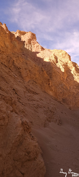
The trail goes right up the canyon. The sides of it shows an assortment of color, not as vibrant as some places, still nothing drab about this walk. The UP portion of the initial statement is right. The trail goes against the water flow which created the canyon. Not an extreme ascent, but enough to let you know we are going uphill. The first half a mile is in the sun. For being 70 degrees, it is obnoxious. Sherri stops to put on sunscreen. But when we come to a major divide, we enter into shadows. My spirit is revived and my step becomes more lively. More sand is deposited from the tops of the canyon. It is fascinating just looking at these cones of sand.


Canyon path


And then we round a bend and see a couple seated. And then we realize why they are seated. There is an 8’ dry water fall. Plenty of footholds to go up. Not sure if I could get down without breaking something. And then, according to the book*, there is another waterfall to climb. Neither Sherri or I are enthusiastic about the prospects of this. So we sit on the other side of the canyon and talk with the other couple. A few minutes later another couple comes by. The lady scampers right up the waterfall. The man waits a minutes and follows her. They do not come back.

A few minutes later another couple, we find out from Wisconsin. They look at the wall and the guy goes up it, only to return about five minutes later. He sort of figures out his way down, jumping the last several feet. They leave, so the other couple is left with us.

Sherri in the Canyon
We talk about several things-where we are from-they are from Eugene, Oregon. Their next place to go is to Joshua Tree and then to San Francisco. As they are about to leave I notice he has a backpacking backpack with him They have done the JMT in sections. We exchange notes about our experience. Their trail names are Fungi and Fragile Forder (in real life it is Jeff and Janice). Glad to have meet them. We realize that Janice was the one who yesterday warned us about the party campsite.

After they leave, we also go on down. There is a side canyon we go up-only a hundred or two yards until we come to a truly impassable dry waterfall, about 25-30’ up. We turn back and make good time back to the parking lot. Shortly afterwards the couple who went up the wall returned and said the view was great up there.

Gary and Sherri at Artist Pallette
Sherri had been reading about a trail in the book* called Artist Dips. It is a route on Artist Drive between two dips in the road. We go drive the road, see the dips. Now to see if we want to actually walk it. There is two dry falls on the route. One 5’, the other 7’. At least we would not need to climb down the walls. See our November 18th hike.


Afternoon meditation
We feel it is getting a bit warm, so we head up to Zabriskie Point, which is a couple thousand feet above the Valley floor. Before we go to the point, we find a spot in the shade and have lunch. Sherri goes into her meditation mode-I thought she might have fallen asleep. So we rest for a lot longer than our five minute allocation. Afterwards, we go up to the Point, a short, but steep paved trail. We take a look around. I take note of Manly Beacon-I am reading Manly’s autobiography. We talked about doing the Badlands Loop from here, but decide not today.
 
Badwater from Dantes View

But there is still time for an adventure. Up the road is the 20 Mule Team loop-driving. We take that and are duly impressed The route is only a mile or two on a dirt road. I think the idea is give the tourist an example of the type of terrain these teams had to drive. It is an enchanting area.


We continue our drive to Dante’s Peak area-you cannot drive to the peak. The area is 5,300+’ above sea level, right above
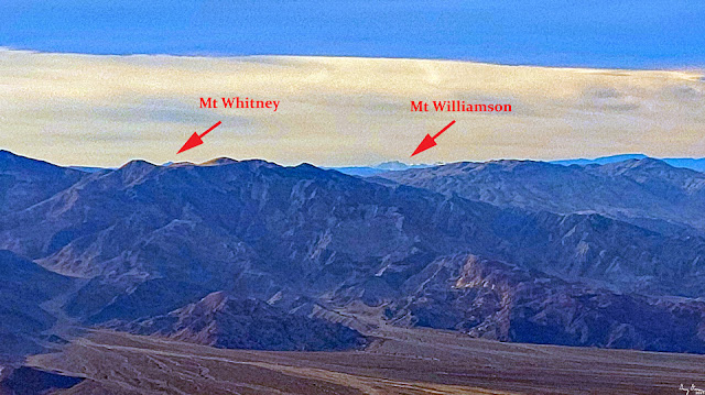
Badwater which is 200+’ below sea level. Quite a contrast. The view is awesome. Clouds stretch out as far as we can see. But the view down and across the Valley can leave ne with a case of vertigo, if you are not careful. Looking beyond the ranges around the Valley, it looks like I can see Mt Whitney. A Wow! moment as you can see the lowest and highest points in the continental United States from here. (In looking at PeakFinder, I am wondering if what we are seeing is Mt Williamson. Still a pretty close relative to Mt Whitney. I suspect a bit up we would see Whitney.)

At Dantes View


The book* says that it is an easy one mile walk to the peak. There is plenty of light, so we decide to do it. While I do agree that the rise is not bad, the trail itself is cut above a drop off. When we come to a split in the path, we go to a point which overlooks the Valley. The rest of the trail looks a bit precarious. Even the trail to this point is not without its nervous points. We decide this is good enough for us, so we turn back.

A couple is trying to determine if they want to go to the point. The woman is a bit nervous about it. I give some “sage wisdom” about how to tackle it. When we look back, they are standing where we were on the point. By the time we get back to the parking lot, they are also there. We high five their accomplishment. They ask what else, but they are going on to Las Vegas tonight. So there is not much else. We share the wonders of the parks in the west. Then it is time to head back to camp.

While up at the Dante Peak area, we noted the sky growing dark, not only because of the sunset, but because clouds were gathering. It looked like up north might be getting some rain. So we stop in at the Visitor Center. They say no chance of rain and only clouds. Sounds good. Not going to put a fly on the tent then. We also stop at the market and get some ice and syrup. Then back to camp.

Sherri fixes dinner-soup and a hot cheese sandwich. Tastes good and is satisfying. At 7pm, we phone in to Zoom for our House Church, We only stay as long to hear the prayer requests and then leave before Bible Study. It is dark here. Shortly afterwards, we get prepared for bed. Lights are off by 9pm.


Background

William Lewis Manly-Death Valley in '49, This is a journal well worth the readng, not for the literary value, but to see the dangers of the time to get to the California gold fields.

Best Easy Day Hikes Death Valley National Park. We went on two hikes listed in this book on this day:

  • Desolation Canyon. The book has as a moderate hike. This is if you go up and over the two dry waterfalls. We just went to the base of the first waterfall. For this it is an easy hike. The description of the hike seems pretty good.

  • Dante’s View and Point. The book has this as an easy(???) one mile hike to Dante's View and Peak. Elevation rise of 229'. While the trail itself is easy, it is a use trail on the side of a ridge. So the "easy" part is a bit misleading, particularly for those with height concerns.


Extra Photo's

Entrance to Desolation Canyon

Erosion

Color in Desolation Canyon

Canyon as a wash

Gary in Desolation Canyon

Scree slide from the steep canyon walls

Golden color canyon walls

20' dry waterfalls

Sherri going out of the canyon

Artist Pallette

Badlands and Manly Beacon from Zabriskie Point

Badwater from Dantes View


Mt Williamson from Danes View

Badwater from Dantes View

Trail to Dantes Peak

Looking north from Dantes View

Looking across into Nevada and the Great Basin

Artist Pallette