Wednesday, May 15, 2013

May 15, 2013 - Nevada Falls

Title: May 15, 2013 - Nevada Falls
Trail head: Happy Isles
Hike Info:
Trail: Mist Trail
Destination: Nevada Falls
Distance:  5.7 miles
Travel Time: 7:25 ( mph)
Moving Time: 5:00 ( mph)
Elevation Rise: 2,000'
Maximum Elevation:  6,020'

Gary and Sherri in front of Vernal
Description:
What a fine morning! We will be hiking with our mid-week meetup group today--gathering at Kohl's at 6:30. Bill and Daniel car pool with us and the conversation ranges and does not stop. We do stop at the Tenaya Lodge in Fish Camp before going into the park. We arrive and at the Camp Curry overflow parking area around 9:15. By the time John had herded all of the cats into a group and we started out, it was 9:45.
Sherri and the do not go this way


Rainbow over John and Cathey
The first half of a mile was to Happy Isles--a pretty level walk, good to get our legs stretched out. But once we cross the Happy Isle Bridge and start up the trail, we get the the familiar climb up to Vernal Falls. This is a paved trail--usually is crowded, but today it is manageable.  We get one of the best views of Illilouette Falls I have seen. You almost wonder if NPS has pruned a few branches out for the view. Sherri and I both feel pretty good about our climb, not nearly as winded and the legs feel strong. Of course, neither one of us have our backpacking packs on.


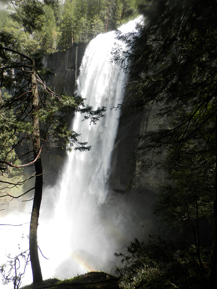
Vernal Falls from Mist Trail

Nevada Falls
Vernal Falls looks fabulous-of course, it is rare when it does not.  The meetup group re-groups and starts our climb up the Mist Trail. Going up the JMT at this point is not an option since a rockfall happened recently, closing it. I do not put my rain jacket on going up--probably should have. Like usual, Sherri and I are towards the back. But we feel comfortable back there. The Mist Trail is well-named. I get soaked-shirt, pants, hair, boots. But this experience is shortly lived, since the sun and air at that altitude quickly drys us off. We all make it up ok, some of us with more apprehension about going down.

We continue on up the trail. This long up is started to wear on some of us, so we move pretty slow. Also the trail climbs a vertical slope a series of rock-embedded switch-backs.  The rock is hard on the feet and legs, we fear we may need to come back down this once we get to the top of Nevada Falls.

Vernal Falls
Nevada Falls
But the site on top is spectacular. The Spring runoff rushing over the edge of Nevada Falls. The clear air vista of this part of the Merced all make for a wonderful view.Almost everybody has arrived at the top before me. But we do rest up here for at least half an hour--or should I say we gather in the sights. I find a person who has come up the John Muir Trail from Vernal Falls. He says that is open, to the relief of everyone.

The John Muir comes up the other side of Nevada Falls, so we are given a whole new view of these falls. In my opinion, and Sherri's, this side is the better view. But both sides are good. It certainly is easier on the knees. But easy is a relative term. You still descend pretty steeply. And we still have the Mist Trail to go down, since the section between Vernal and the bridge is closed. When we do go down the Mist Trail, we form a conga line. First the six of us last ones. Then the line which forms at the rear. But we make it down safely, and a bit wet. My new REI Rain Jacket UL does keep me dry-it is ready for backpacking.

Conga Line coming down Mist Trail
We get back to the car a little after 5. When John annouces that we are going to Todd's for dinner, everybody raises their hand to come. We finally make it back to Fresno around 8, tired but happy.


Tuesday, May 14, 2013

May 14, 2013-Four Mile Trail

Title: May 14, 2013-Four Mile Trail
Trail head: Yosemite Valley
Hike Info:
Trail: Four Mile Trail (missing GPS)
Destination: Glacier Point
Distance:  9.2 miles
Travel Time: 5:15 (1.75 mph)   Approximately
Moving Time: 4:45 (1.94 mph)  Approximately
Elevation Rise: 3,200'
Maximum Elevation: 7,214'


Description:
This is a trail which we have wanted to do for a long-time. But it is a strenuous trail, rising from the Valley floor to Glacier point, a rise of 3,200'. We drive up to the valley from Fresno, about 2 hours, getting there around 11. 


There are two easy parts to the trail. The first 100 yards are flat. Then you start rising up the side of Yosemite Valley. It is switchbacks for the next 1,000' rising. But there is compensation to the strain the body feels. Being Spring-time, there are many places on the Valley wall where water is coming down. One of these is right in front of the trail during the first part-Sentinel Falls.

But the big sight is Yosemite Falls. It is right in front of you the whole trail up. But instead of being boring, you see it from different perspectives. From the Floor, you see the Upper and Lower Falls. But as you rise up, the Middle set of Falls comes into view. You realize how little of the Falls you normally see. While vowing not to take many pictures on this trip, the camera is grabbed by the sight of the Falls.

El Capitan
Yosemite Valley
While Yosemite Falls is plainly the star of the show, there are other sights which provide the eyes plenty of candy. Such as El Capitan rising up to the west. Further down the trail, Half Dome and Royal Arches come into view, capturing your attention. As the trail rises up further, the country to the north come into view.


Yosemite Falls
But that is not the only thing coming into view--dark clouds. About an hour after starting the climb, the sounds of thunder starts to be heard. But the trail is dry, so the climb continue on. At the 2,200' mark,  Union Point provides a stopping point for lunch. The Point is a bit disappointing after all the splendid views on the way up. So a few shots are taken and the Point is left behind.
Yosemite Falls

About 10 switchbacks and 800' later, the trail rounds the spine from Sentinel Dome and Moran Point. Half Dome and the east side of the Valley come into full view. Splendid! Also the trail levels off and goes for a slight descent for the next 3/4 of a mile--relief. Then it is a quarter of a mile and a 300' ascent to Glacier Point.
Half Dome

Glacier Point has good views--which is sort of like saying that the Empire State Building is tall. What else does Glacier Point have but great views? One thing which is gotten is a good view of the place we will be doing tomorrow--Vernal and Nevada Falls. After being up on the Point for about half an hour, it is time to start heading back. The sound of thunder is getting closer and the clouds are more threatening. But there is still time to stop and talk to a backpacker which I talked with on the way up. He is a new backpacker and is concerned about the storm and what to do with lightening. So we talk a while and go our different ways.
Glacier Point
Rain on Half Dome

The trip down is a lot  faster, that is until  a few drops start falling. Then the lightening  starts being visable and the thunder is 8 seconds away--getting closer. By this time it is a toss up on which way to go, so it is down. Then the lighting gets closer-about four seconds, or less than a mile away. The rain is coming down. Met up with some people from back east who take comfort in people who are knowledgeable of the area. The good part is the lightening is up on the top of the ridge and we are 1,500' below that so we should not be in too much danger, but are keeping close to the side of the walls and not trying to be too much exposed.

By the time the bottom is reached, the clothes are sopping wet, along with the pack and everything else. But great fun! By the time we reach Todd's in Oakhurst, the clothes are mostly dry; the bed felt good and warm that night.
Yosemite Valley


Sunday, May 12, 2013

May 12, 2013 - Back to Parking Lot


Title: May 12, 2013 - Return to Car
Trail head:  Tarwater Primitive Camp
Hike Info:
Trail: 
Destination:  Sam McDonald County Park Ranger Station
Distance:  7.18 miles
Travel Time: 4:51  (1.48 mph)
Moving Time: 4:35 (1.57 mph)
Elevation Rise: 1.516'
Maximum Elevation: 1,139'

Description:

Woke up at first light, but stayed in bed, feeling lazy. But got up a little before 7. Bathroom a calling me. Then went for a little walk up the trail. Came back. Evidently, I am not the only one feeling lazy. Everybody else asleep until Steven got up around 8:30. People starting to arose at 9:29. Breakfast is oatmeal and mosquito's. Maybe some Tang as well.


Youth Camp Sign
We mosey around camp for awhile, even doing some yoga,  and leave at 11. We make pretty good time hiking the Pomponio Trail from our Tarwater Camp. We raise up, passing the Honor Jail paved access road. Saw a fox scurrying across the bridge which we crossed a few minutes later. The Pomponio Trail leaves the road and climbs the up several hundred feet, under the shade of some oaks. We meet a ranger on horse back and talk with him for awhile. He gives us some tips on navigating, particularly getting to the proper segment of the Brooke's Loop Trail.

We get to the junction of the Shaw Flat Camp at 12:30. We have passed elevessees, so we stop for lunch while some of us head off to use the Shaw Flat Camp pit toilets. Relaxed, so off we head again. The Pomponio Trail interweaves with several other trails and fire roads. Sherri is performing as the GPS. This is outside of her comfort zone. But she does well, considering what the map says and where we want to go. By the end of the hike, she is tired of being the GPS though.

Townes Creek Water Fall
Family Shot
We go to the second Brooke's Loop Trail junction. This trail is a loop. The horse back ranger said this was the prettier part of the trail and not so exposed. He is right about it being prettier. We shortly come across a little waterfall which empties into a pool. This is Townes Creek. We stop and gawk for a while, taking in this little bit of paradise before continuing on.


Townes Creek
From here, the Brooke Trail leads us up a ridge, about a 1,000' climb. It is mostly among trees, but close to the top, we hit more open land. Here we feel the mid-afternoon sun hitting on our bodies. While it is not the oppressive heat of the Central Valley, it still causes us to reach for the sunscreen and other sorts of protection. 
 
Andrea and Steven
At the end of the climb, we hit our old friend, the Townes Fire Road--a different segment than we had coming in. We will follow this road all the way back to the car. 


Saturday, May 11, 2013

May 11, 2013 - To Tarwater Camp


Title: May 11, 2013 - To Tarwater Camp
Trail head: Sam McDonald County Park Ranger Station
Hike Info:
Trail: Heritage Grove Trail, Brooke's Loop Trail,Townes Fire Road,  Bravo FireRoad, Canyon Trail, Tarwater Loop Trail
Destination: Tarwater Primitive Camp
Distance:  7.88 miles
Travel Time: 6:10 (1.28 mph)
Moving Time: 3:59 (1.98 mph)
Elevation Rise: 1,302
Maximum Elevation: 1,294


Andrea and Steven
Description:
Got up at 6:30. Andrea and I went to Walgreens and Smart/Final to get a few items, including breakfast for this morning. Then it is off. The first point of contention was will the GPS get us to where we want to be? Resolved by being more specific with the coordinates. Got to San Mateo's Memorial/Pescadero/Sam McDonald County Park around 8:45. Talked with the ranger about where to camp-Shaw Flat or Tarwater. He recommended Tarwater if we do not mind walking a bit farther so to Tarwater we will go, a bit more round about way.

Gary on Townes Road
After eating a light breakfast of an onion bagel and cream cheese with cherries and bananas we start on the trail. The car is left at the Sam McDonald Park Trailhead and we head down the Heritage Trail. Pictures are taken and the feet hit the dirt around 10. The first part of the trail is through some coastal redwoods. We climb, but not badly. After a mile and three-quarters we reach a short trail down to Heritage Grove. Andrea and Steven visit it and reports that it sort of looks like every thing else. Lots of redwoods. 

We climb out of the basin and hit the Sierra Club's Hikers Hut, well the trail for it. The climb is .8 miles and rises up four hundred feet. At the top of the ridge is a large grassy field. The looks of the field is one of refreshment and life. 

It is getting close to lunch time and we are looking for some shade from the sun directly overhead. We accept some shade on the side of the road for a quick snack. But just a little ways away, Andrea and Steven see a picnic table in the shade with a view lunch is the usual. After watching a butterfly dry himself, we take off, refreshed.

Our Friend
The trail quickly turns into the Townes Fire Road, then leaves us, as it hands us off to the Bravo Fire Road. But not before a gopher snake gives us a bit of excitement. Earlier, if we had been more alert we would have headed a little off the roads onto the Brooke's Loop Trail, but it joins us as it crosses the road. We take the Canyon trail. It descends several hundred feet down into the Tarwater Creek. We have left behind the redwoods for the time being and see more oaks with a lot of brush low down.

Tar Water
When we hit Tarwater Creek, we find out why it is called that. We see tar flowing down the creek. When we get to cross the creek, there is naturally bubbling oil right next to the creek. It is obvious that is the source of the creek tar.

Even though we are only a mile and a third from camp, we stop to rest by Tarwater Creek. We stop a lot longer than we thought we would. Each of us take a nap and are feeling pretty lethargic. But after 45 minutes we struggle to get up and move own the Tarwater Trail.

The Bumblebee Women
It does not take us long to travel the rest of the way to camp. We come across three people who are trying to find Tarwater also. We direct them and tell them where it is. They are content to follow us. We decide site 5 will suit our purposes with two hammocks and a tent.

Water is a problem. Pescaderio Creek is down a deep bank, maybe 70' below us. So I walk around to see where else to get water. Eventually I walk down to the bridge on the trail, crossing Pescaderio Creek, about 3/8ths of a mile down. But access is easy there.

Sherri fixes dinner-freeze dried stuff-beef stroganoff and chicken teriyaki. Not bad. We had brought wine a long, so we celebrated Mother's Day a day earlier. Girl scout cookies and chocolate made there appearance, only to be devoured.

We finally hit the bed at 9.


Tuesday, May 7, 2013

May 7, 2013 - Teutonia Peak Trail

Title: May 7, 2013 - Teutonia Peak Trail


Trail head: North of Cina
Hike Info:
Trail: Teutonia Peak Trail
Destination: Teutonia Peak
Distance:  3.15
Travel Time: 1:50 (1.72 mph)
Moving Time: 1:30 (2.10 mph)
Elevation Rise: 615'
Maximum Elevation: 5.750'


Description:
This trail is in the middle of no place. For awhile, Sherri was wondering if anybody had ever been out here. Well we sort of knew that somebody had been since there was a paved road. But we had driven about 45 minutes without seeing anybody. Then we saw a few maintenance trucks, and then the town, and I say that loosely, of Cina-we did not see anybody in Cina, just some buildings. Finally we started going through a forest of Joshua Trees, which included a memorial of the VFW-the Mojave Veterans Memorial. But we finally find the trailhead.
There are several signs explaining the area and the trail. Before we take off, an RV pulls into the parking area. Out pops a couple of kids playing cowboys. Their Mom and Dad are not too far behind.
The first half of the trail is pretty flat. But we are surrounded by Joshua Trees all the through this section. According to the NPS site, we are passing through the world largest Joshua Tree forest in the world. Sounds impressive, and these tree are—at least to those of us who are not used to these sights.
Dirt roads criss-cross area and the trail. We go on and off of them. Evidently there is still some mining going on in the area and these roads help service the mines. To us, they seem a bit confusing, so we wonder if we are on the right road or did we miss the path someplace. But eventually we find the trail and are heading off in the right direction.
After a short ways from the roads, we start climbing up the ridge. Not a steep climb. But, being in the desert, even in May, things are warming up in the afternoon. Once we top the ridge, we enjoy seeing the desert to the west and east and north. The trail continues up the ridge on the west side towards the south.
We come to the end of the trail about 50-70' short of the summit. There are big boulders blocking an easy trip to the summit. Still, we are able to get a view, looking out in the distance. An enjoyable time we spend on top.
The return trip is just a repeat of the trip up. We do meet our RV family. They are from Switzerland, touring the US. Interesting that a family coming so far would enjoy this trail while most people along I-15 do not even know this area is here.


Wednesday, April 17, 2013

April 17, 2013 - Chilnualna Falls

Title: Date, Hike
Trail head: Wawona-Redwood Cabins
Hike Info:
Trail: Chilnualna Falls
Destination:Chilnualna Falls
Distance:  7.84
Travel Time: 6:15 (1.25 mph)
Moving Time: 4:42 (1.66 mph)
Elevation Rise: 2,346'
Maximum Elevation: 6,408

Description:
It is Wednesday, and another hike with our meetup group. This time it is to Chilnuala Falls, near Wawona. We meet at Kohls at 6:30 and get to Wawona at 8:30, after stopping at Tenaya Lodge for a restroom break. Bill and Danielle rode up with us--it is Danielle's first time with our meetup group. She is from Breckenridge, CO.

By 8:50, we are on the trail. The first part is one of the more steep parts of the 4 miles of trail. We make pretty good time. Last night's wind storm brought a light covering of snow to the mountains, about 1-3" worth. But this is good. The trail could get hot if it wanted to and the snow provided a pleasant covering. Because of the climb, after a mile I take off the jacket and hike in short sleeves.

Part of Chilnuala Falls
Snow and ice would be our constant companion on this trail today. But it made for some interesting and beautiful presentations as we walked along. The creek's roar from its cascade accompanied us all the way up to the falls. While we knew we were going up, the semi-winter scenes made the going some easier. The manzanita bushes were out in bloom, with the mountain misery still sparse and unscented. Oaks lined the path with some of sugar pines towering above.

After the first third of a mile, the steepness decreased. But we were still going up, but at a more moderate pace. Around each corner the cascades which make up the Falls would show a different view. Even when we were coming down, the Falls looked different. Never a dull moment.

Chilnuala Falls
Approaching the Falls is a long piece of exposed trail, running across granite. In the morning, this is shaded. With the snow, parts of it are icy, but manageable. I did slip once and had to balance myself against a large rock or take a tumble. When we round a corner, the we find we are close to the water's edge and a few of our group have decided this is a good stopping place for them. But up we go another quarter mile where the rest of the meetup group has availed themselves of a fine place to have lunch and sun-bath, clothed of course.  At this spot, the one remaining cataract shows itself with other parts of the falls below us. Even though there is ice on the river, the sun feels warm.

Snowy path

It is time to come down. After the trip up, going down is a breeze. Everybody charges ahead, even Sherri who usually holds back. So I get to be in the company of John and Cathey on the way down. Good conversations, which is part of hiking. That is to enjoy each other and get to know others better. Even in our college days, that was at least equal to the joy of walking in the beauty of the Sierra's.

We get back to the car a little after 3. Most of us are ready for a bite to eat and what better place to eat than Todd's in Oakhurst. It does not disappoint as we all are satisfied. Sherri even got some blueberry breadpudding.  A good day it was.


Ice fibers

Icy Cliff

How Cold Was It?


From Ann Marie Brown's book, California Waterfalls, page 95:

Most people dopn't expect too much from the southern section of Yosemite National Park. Sure, everyone visits the Mariposa Grove to see the big sequoias, but other than that, the area doesn't take up too much of the average visitor's itinerary. But while everyone else is in the valley or at Glacier Point or Tuolumne Meadows, you can sneak off to the southern park of the park, take a rigorous hike, and be rewarded with a terrific waterfall: Chilnualna Falls near Wawona, one of my favor falls in Yosemite.


Wednesday, April 10, 2013

April 10-11, 2013-Redwood Canyon

Title: April 10, 2013 - Redwood Canyon
Trail head: Redwood Canyon Parking Lot

Hike Info:
Trail: Redwood Canyon
Destination: Cabin in Redwood Canyon

Distance: 5.7 miles
Travel Time: 3:02 (1.88 mph)
Moving Time: 2:35 (2.21 mph)
Elevation Rise: 549'
Maximum Elevation: 1,296'


Description:
We were scheduled to go backpacking yesterday, but the weather forecast had it being in the upper 20's in the morning and with the wind chill, in the upper teens. A bit too cold for us. But there is not a significant amount of wind forecast for today, so off we go.

 We leave Fresno around Noon. Well almost. The plan was to grab a Subway sandwich and split two foot longers in half. Eat one half for lunch and the other half as dinner. Got to Subway and found we did not have money-used credit card. But returned to the house to eat and retrieve the loot. By the time we left, it was 1pm. We promptly got into. Traffic jam on 41 which held us up 20 minutes. But then it is off we go. Picked up the wilderness permit and got to the trailhead at Redwood Canyon. We got on the trail a little after 2:45.

Sherri and a fallen giant
With the late start, we will go straight down the canyon. Originally, we thought about doing a loop by following the Sugarbowl ridge and drop into the canyon. As it is, it is being a beautiful hike. While yesterday's hike at Nelder Grove was really nice-one we want to do again, this one has us wandering right amongst the redwoods. These trees seem to be a lot younger than the Mariposa or Nelder Grove trees. So they are straighter and slender, with a spouting at the tops of them.

Root base of a Sequioa
We are not going fast considering we are heading downhill-tomorrow will be a lot slower. Still we make good time. We come to the Sugarbowl and Hart tree trail junctions after about an hour. The creek is still has water in it. We say we will hike for another hour. The trails seems to have been rerouted since my 1993 topo map. We do not seem to climb nearly as much as the topo map says we should, still we can feel this is the first time out for the season. Even slight rises causes us to realize we have a ways to go before the JMT. But we are enjoying the trail, with its canopy of evergreen. As we go down lower, the Sequoias are sparser. Makes you appreciate the upper part of the canyon.

As we close in on five, Sherri asks, where is the water. I say right over there in the creek which we have been following. But then I do a double-take, where is the water? The creek is dry. So we continue to walk along. But we are thinking that we will need to go back up to the junction, if we we do not find water soon. We think we are close to a cabin marked on the topo map, and then there is a creek marked close by. We get to the cabin. It has an outhouse, some tables, and some faucets. But the creek is dry beside it. But we follow the line which connects the faucet. In a couple of hundred feet we hear the sound of trickling water. So the tent is pitched, water is collected and the Subway sandwich is devoured.

It is getting cold, and it is not even 8 yet. But we will turn in soon to our hopefully warm sleeping bags, inside of our warm tent. Read for a little while. In the sleeping bag, shut down the iPad, and it was off to sleep.


Title: April 11, 2013 - Redwood Canyon
Trail head: Hart Tree Trail

Hike Info:
Destination: Redwood Canyon Parking Lot

Distance: 8.8 miles
Travel Time: 5:57 (1.48 mph)
Moving Time: 4:29 (1.96 mph)
Elevation Rise: 2,059'
Maximum Elevation: 1,075'


Description:
Slept pretty well. For the first part of the night, was a bit cold, so kept on rolling over to get another part of my body warm. During one of Sherri's times out, I put on socks. Slept warm after that. Woke up around 6:30. Warmed up the iPad, and read from 1 Samuel and Luke. Then went for a walk. Meant to only go to the next creek, but walked almost to Big Springs. Just more forest. This section of the trail looks hardly ever used. Still no water. Maybe at the springs, but I stopped about a quarter of a mile from it. Thought I was hearing a whistle, but I think it was some birds. Nice uphill back. Got back at 8:30. Sherri is still in her bag. She got up a little after 9.

Have I said anything about the accommodations? Like I said, we camped near a cabin. It was locked up, but looked like it was in good shape. It may be used by people who do scientific studies. Wood has been cut, plus there are water faucets. They do not seemed to be turned on yet. Also there are tables, which we used to cook at eat at. But the best part of the area is that there is a two seater loo!

CalFire
We pack up and leave at 11. We make decent time going up the canyon. We start seeing more redwoods in front of us, inspiring us to go forward. As much as we went down, we come back up again. So we are feeling the packs a lot more than yesterday. But the coolness of the morning helps makes it refreshing. We do have one incident. As we were walking along, with Sherri in the lead, a downed branch reached out and tripped me. I suspect if I had not packed a bit top heavy I would not have fallen. But as it was, the pack went over the top of me. Nothing hurt, except for pride. Sherri was concerned, but not badly. Got up and started walking again.


 Had lunch at the trail junction. A group from CalFIre came along with a training mission. We watched them go across a log we had inched over. The log was a fall end Sequoia.

After lunch, we start up the hill towards the Hart Tree. It is a pretty good climb. It shows us how out of shape we are. But we are making good, steady progress. The many standing Sequoias break up the climb for us. While we do not stop to gawk at each tree, we do look at many of them. Even the ones lying on the ground. The Fallen Goliath is not just a tree, it is one which was truly a giant in the land of giants. We feel like hobbits among the Ents.
Buena Vista Peak
Moss and a tree shadow

Arrive at the car at 4:50.