
Title: June 17, 2020 - Chicago Stump and Road 13S03
Hike Info : Description : Trail Lessons : Extra Photo's : Flowers and Plants


Hike Info:
Type: Hiking
Trail: Chicago Stump Trail and Road 13S03
Destination: None-just wandering
Distance: 3.22 miles
 Start Time: 11:33
End Time: 2:23
Travel Time: 2:50 (1.14 mph)
Moving Time: 2:06 (1.53 mph)
Elevation Rise: 666'
Descent: 465‘
Maximum Elevation: 6,647'
Description:
I am glad I went on this walk
for several reasons. First, I have not really been in the area
before. Next got to see Delilah
from a different view. Third, I figured out how badly out of shape I
am in. Having been thankful for all of that, would I put this down as
a hike to look forward to doing again? Probably not. Even though at
certain times of the year, early Spring or late Fall this might be
nice. But probably the gate to the area will be closed.
 |
| Sherri and Steven hiking |
I get up around 6:15, knowing
that we will not be going anytime soon. Steven is up with Korra
around that time. But Sherri is up later on. I think we leave a
little before 10am. Sherri is driving. Korra is not used to being
driven and it upsets her tummy. But on the whole, she travels without
too much bother.
We stop at the Grant
Grove
visitor center-it is closed due to the virus. But the restrooms are
open. We decide that we will head towards the Converse
Basin and
decide what to do there. The Chicago
Stump
sounds like a good place to go. I suggest we can also hike some on
Verplank
Ridge.
 |
| Gary and the Chicago Stump |
 |
| Steven and Korra |
The hike to Chicago Stump is
really nice-also short, only a quarter mile or so, one way. Only
people on it, until we came out. The stump is huge. No wonder the
people back East did not believe. Who would? As has been observed
before, it was a sad day when this magnificent tree was cut down only
to be scoffed at.
Coming out, there were four
people coming by who were not wearing masks-we were, when we saw them
from a ways away.. We put on our masks and stepped off the trail. I
think they were pretty oblivious to any need to have protection.
Now where to? I suggest we go
down a road which I had not been down before, Road 13S03. It follows
Verplank Ridge. Nobody else has a better idea, so off we go. We walk
back to the junction. There I find a wall and wonder what the wall is
for.
 |
| Rock Wall |
There is a chained gate which
we go through-it is a forest service area. The gate is to keep cows
from grazing outside of their confines. It does seem strange to have
cows wandering around so close to the park, but never seeing them.
 |
| Guardian Bovines |
We soon do see them as they
herd together a little ways down the road. Not sure who is more
concerned-them or us. They have horns while we have poles and a dog.
They back away-I wonder for how long? But as indicated, this is a
dirt road. It does not look like it is driven often-there are some
tire tracks in the dust. And it is that word, dust which may describe
the road. I think the cows' hooves have pulverized the road’s dirt.
While not choking, it has a feeling of we will need a shower when we
come out.
 |
| Hilltop lunch |
There is a little ephemeral
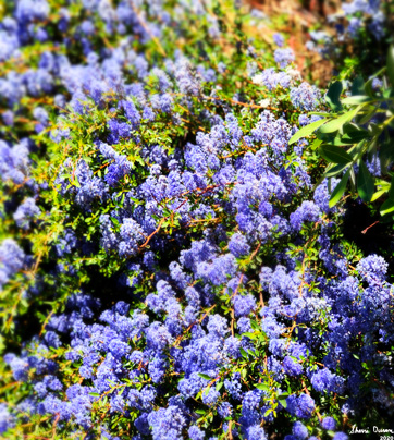
creek following the road for a ways. And where there is water, plant
life will follow. Which means we are gladdened by the sight of color
from an assortment of flowers. We meet up with our bovine friends
again. This time we decide to head up a hill to have lunch. It is a
nice little spot-just glad it is not a hot day. We can see some of
the surrounding area and to the park boundary.
Now back to the road, and the
cows. They seem to be driven off by our presence. For now, they exit
the road and go down a ravine. While the road is hot and dusty,
fortunately the day is not. After a decline of about a mile, there is
a leveling where we go over some small ridges.
 |
| Korra keeping watch on the cowe |
We meet the cows again. I
think Korra is getting more fascinated by them. She does not chase
them but eyes them. Steven has her under pretty good control.
I have been glancing over to
the west. McKenzie
Ridge is
what we see. Sort of interesting seeing the back side of McKenzie
from what we normally see. But what I am really looking for is
Delilah. We top a ridge and I think it is time to turn back. The road
will take another long descent. But I go over a ways to the edge and
spot Delilah! Now I am satisfied.Of course, from this distance, even
under full 30x magnification, Delilah looks pretty small. Now I
wonder how much we are actually seeing through our binoculars from
Delilah.
 |
| Walking Road 13S03 |
Time to start back. Korra and
Steven are setting a pretty good pace. Even Sherri is doing well. Me?
Well I am trudging along, falling further back until Sherri waits for
me to catch up-sounds familiar? Sounds more like role reversal.
Not a whole lot of interesting
stuff on the way back. It is just the reverse of what we did coming
forward. When we reach the top, we poke around the rock wall and
only discover there is cement dumped around the bottom. Also there is
a mound behind it, like a retaining wall. Wonder if it was a mine or
something.
Steven has moved up the car a
little ways. Bless you my son. Steven is driving us back and I am
with Korra. Both of us nod off at times. No stopping for food on the
way back-not sure if it is a positive or not. We make it back home
before the 5:00pm traffic. Maybe not content, but happy.
 |
| Delilah Lookout |
Trail Lesson: An
early start avoids the heat.
Extra Photo's
 |
| Backside of McKenzie Ridge |
 |
| Korra chasing a lizard |
 |
| Pine Ride and Delilah Lookout |
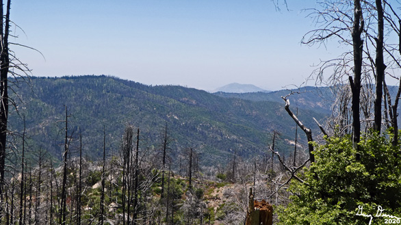 |
| Bear Mountain in the background |
 |
| Terraced Manzanita? |
Flowers and Plants
 |
| Indian Paintbrush |
 |
| Blue Elderberry |
 |
| Blue Elderberry |
 |
| Blue Elderberry |
 |
| Mountain Strawberry |
 |
| Young Sequoia Gigantiea |


No comments:
Post a Comment