Title: March 20, 2024 - Eureka-McKay Forest
 |
| From McKay's web site |
Type: Hiking
Trail head: McKay Community Forest - Northridge Dr
Trail: Bob Hill Gulch Trail, Triple C (Switchy) Trail, Perimeter Trail
Destination: Loop
Distance: 2.1 miles 1
Elevation Rise: 431 '
Descent: 469‘
Maximum Elevation: 333'
1
 |
| Start of trail |
I am tired after yesterday’s drive, consequently I got up at 8. David and I went to Winco to pick up milk for me. David started BBQing/smoking chicken breast for tonight’s dinner. I had a breakfast of granola. Most of the morning we just talked and enjoyed each other’s company. After my peanut butter sandwich lunch, I rested for an hour until I was told they were going out for a hike at the McKay Community Forest.
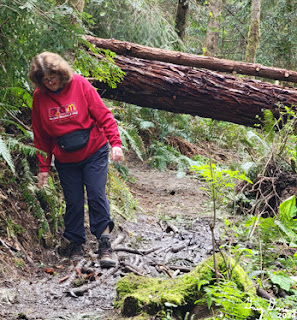
McKay is only about a mile away from David’s place, but it seems like it is a whole different world. No it is not a desert, but it feels like it is shut off from the rest of Eureka. There are several short trails in this reserve. For the first tenth of a mile, we walk on a packed gravel trail which is ADA accessible. We then turn onto the Bob Hill GulchTrail. The trail starts out as a pretty wide dirt trail which descends down into the Gulch. About half way down, this wide trail turns into a single file trail and the trail turns muddy. Also it is only for hiking rather than multiple use.
 |
| David and Sherri going down into the Gulch |
It should not surprise us about the mud. This is Humboldt. David says that it was a lot more muddy just a few days ago. The trail continues to descend. We see trillium and giant skunk cabbage. The cabbage we will leave behind once we leave the bottom of the Gulch, but the trillium will stay with us throughout the hike.
This trail loops around, avoiding crossing the creek. There is a connector being developed to go to Redwood Fields. David offers to pick us up there, but we decline. There is a 0.4 trail called the Triple C (Switchy) Trail. The elevation we have lost in the descent is now being made up with a climb back up the ridge. This is also muddy. And steep-jelly belly time. Oops! I forget to put them in my pocket.
 |
| Muddy trail |
A word about the general environment. It is an overcast sky with no rain in the forecast-it turned out there were a few drops which fell, but nothing significant. Redwoods and other species of trees give the forest a feeling of walking through a space of earth which is primordial. Ferns grow on the side of the trail along with other bushes. There are occasional berry vines. But all are under a canopy of green.
When we have hit the top of the ridge, the Triple C Trail bisects the Perimeter Trail. This trail runs on both sides of the ridge. We go left or west. The trail continues to ascend, but at a slower rate. We go for aways when we reach another trail. David follows this trail which leads to another part of the Perimeter Trail. Eventually we get back to the original gravel trail. But not before getting our shoes a bit muddy.
 |
| David and Trillium |
I am not sure what I should feel about my body. I think we went about 2 ⅓ miles, with a decent uphill, so I am somewhat pleased with my performance. But also displeased as I should be able to go much farther.
When we get back to David’s house, he gets things ready for dinner. Sherri and I go to Safeway to get some decaf coffee. David is self-sufficient in the kitchen and gets things pretty much ready for dinner. Kevin, of my Hawaii trips, drives up followed by Beth, his wife. We have a wonderful chicken breast dinner and an even better conversation about travels. After they leave, it is shower time, then into bed by 10:00pm.
Flowers and Plants
 |
| Skunk Cabbage |
 |
| Trillium |
 |
| Trillium |


No comments:
Post a Comment