Tuesday, June 25, 2013

June 25, 2013 - Sunrise Creek

Title: June 25, 2013 - Sunrise Creek.
Start of Trail at Glacier Point

Hike Info:
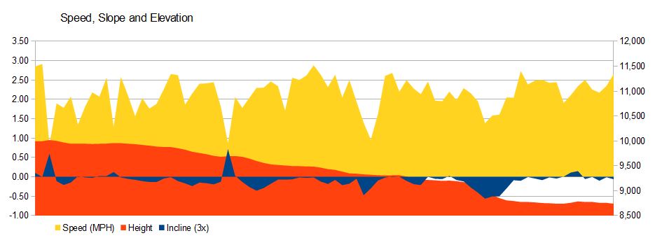
Trail: JMT Segment: Glacier  Point  to Nevada Falls, then to Sunrise Creek
Starting location: Glacier Point
Destination: Sunrise Creek 
Distance:  10.57 miles 
Start Time: 10:37
End Time:  6:21
Travel Time: 7:43 (1.37  mph)
Moving Time: 6:20 (1.67 mph)
Elevation Rise:  2,969'
Maximum Elevation: 7,865'


Not where we started, but true start of JMT


Description:
Such clouds! Some people may say we are cheating, but when you see Half Dome surrounded by clouds, it is worth taking that chance. The clouds would hide the peaks and then let them appear. Just so mysterious and awe inspiring.

I started the day a little after 6. Sherri got up at 6:30. While we were all packed and pretty much ready to go, we sort of dallied-dallied around and did not leave until close to 8:30 or 8:45. Oakhurst was the next stop, at Subway sandwich for lunch and dinner. We got a couple foot long subs. We already had  our wilderness permit, so we did not stop in Wawona. Traveled up the Glacier Point Road and got to the parking lot around 10:15. Along the way, it was cloudy and it sprinkled some on the car.

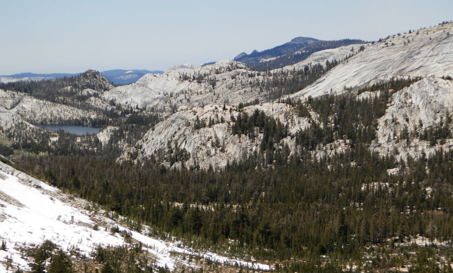
But when we got to Glacier Point (37.72705, -119.5749), the clouds just made the views that much more jaw dropping beautiful. Pictures will not compare to the eye. Words leave a faint image. The clouds parting to make way for Half Dome to be seen. Then they draw back the drapes to hide it. This is the game we got to hike with for the morning.

We said our goodbyes to Steven who is our transportation and restock for Tuolumne Meadows. We even got to climb a ridge and wave goodbye to him as he drove off. Then it is time to descend into Illiluoette Creek. This is the first two plus miles and a thousand feet we go down. The trail is good and we make good time. We meet some kids from the Youth Civilian Community Corps (YCCC) group who are helping to maintain the trail. Thankful for them

YCCC Workers and Clouds
We come to the trail junction and head to the top of  Illiluoette Falls. We can hear the dull roar of falls, the sound being dampened by the humidity? It is the first time we have been on this trail and the falls from here are ever so much better than what you see on the Vernal Falls Trail. While not a large or tall falls, they remind you of lace covering rock as the come over the edge and drop down a couple hundred feet. 

We have lunch on the east side of the falls. Lunch is a quarter of our Subway sandwich. Then it is on to Nevada Falls, via the Panorama  Trail. We steeply climb out of the creek, up around 600-700'. Even with the clouds, such views. We look down and cannot see the trail to Vernal Falls. Great views of the Valley. Then you turn around and see the country where we are going.  So glad to be on this climb. The first time for this section.  We do talk with an above 55 year old hiking group from the Sacramento area.

Yosemite Falls
We then descend the 600' of our climb, down to the JMT and the top of Nevada Falls. Even with this short time away from Glacier Point, I am a bit jarred with the number of people at the top of Nevada. They were behaving well, just the number of people. We do not stop. A quarter mile away is a restroom which we do stop at. Here we find our first Mt Whitney sign: only 215 miles to go.
Illilouette Falls
We eat lunch at a quiet little beach just before Little Yosemite Valley. This gets invaded by some returning Half-Domers. But they leave after a few minutes.

We then start our climb up towards Half Dome Jct. it is one foot in front of another, but we do pretty good. Stop to rest on occasion. After climbing 800' or so, we have another bite of our sandwich at the jct, then continue on. There is a village of campers at the Clouds Rest Jct. We talk for a little while, then it is off towards Sunrise Creek.  We also talk with some PCTers-Instigator, No-Dae and Rehab, their trail names. They started two months ago at the Mexico border and expect to end up at the Canqdian border at the end of Sept. they are going to Yosemite Valley to send a few days off the trail. We exchanged knowledge of conditions. We found out that Muir Pass has the most snow, but should be pretty passable by now,

I will admit, there was a bit of just gritting it out on this. The pack today seems heavier than what I have been used to. But there is only one bear canister, so I am not sure why it feels heavy. The legs are also feeling tired. but we will make it. As I get into a rhythm, I am able to do OK. Around 5:45 we passed the spot which we camped at last year. Sherri just keeps on going. We eventually get to the spot which Andrea and stayed several years ago. We decide this is a good place to stop, and we do (37.75117, -119.48248).

Even though it has not rained today on us as hikers, we decide a tent would be good. It is a it humid. Also the mosquitoes have found us. Dinner is finishing off the Subway sandwich. Then we enjoy some wine-from a backpacking carafe which Steven gave Sherri-and some girl  scout cookies. Some deer have found us, but they keep to themselves. Then it is off to bed around 8. We watch an episode of MacGyver before we start to nod off.

Today's JMT Lesson: You only have what you are carrying.  (A witticism from Sherri).


Only 215 miles to go

Friday, June 7, 2013

June 7, 2013 - Rafferty Canyon


Title: June 7, 2013 - Rafferty Canyon
Trail head: Fletcher Lake
Hike Info:
Trail: Rafferty Canyon
Destination:Tuolumne Meadows
Distance: 7.54 miles
Travel Time: 4:21 (1.73  mph)
Moving Time: 3:14 (2.33 mph)
Elevation Rise: 393'
Maximum Elevation: 10,019'


Description:
Sunrise over Evelyn Lake
This morning it was a bit windy. A stake in my poncho tent pulled up and the side started flapping. Of course, the stake not holding may have had something to do with me rolling over on top of it. But on the whole, it was a pleasant night to sleep in. When there was a bit of light on the horizon, I had my quiet time and read some. Then got up before the sun rose and went for a walk. I went eastward up the trail we went down Wednesday. It was glorious to get to the top of the ridge. I felt I was rising up to meet the Son. What a great mornings to end  the trip.

Got back to camp and the ladies just started to rise when I was putting away my stuff. Also got snow for our Capture California  snowman. Not a bad looking critter which the ladies put together. Then we had our oatmeal breakfast while he silently watched us eat. We did offer our new, cold friend something to eat, but he declined.

Tuolumne Pass
Now it is packing up time, and getting read to leave. We will hit the trail around 8:45. We retrace a little bit of our steps back to Vogelsang, and then down the trail to Tuolumne Pass. Then it is new trail for this trip down Rafferty Canyon. It really is not much of a canyon. We follow Rafferty Creek.Once over the pass, more like a gentle low spot, we broaden out into a nice long meadow. Very pleasant walking.

The pleasantness is intertwined with memories of twelve years ago. Then it was raining, and getting colder by the minute. It probably snowed that night. To compound the time, one of my boot's sole had separated and it turned the this trip from a slog to something pretty tiring.

Rafferty Canyon Hikers
But not this time. As the day gets older, the sun starts wearing on us. We feel the heat and the sun, even through our clothes--it turns out the next day would be the hottest day in Yosemite, ever, at least on record. But we are starting to descend and the trees are getting more numerous.  By the time 11 hits, we are ready for our elevenses. At this point we find this nice little place where the water falls over about a 20' rock, forming a pleasant falls. Enjoyable place for lunch and a break. We all are ready for this break.

But then we sling our packs on as the car is not getting any closer. The trail starts a more downward track. We are now concentrating on getting back to the car. We stop briefly at the John Muir Trail and look at the bridge we crossed just three days ago. Now we know it is about a mile more. Mostly flat. But the heat has taken a toll on us. So our pace slows and the trail turns more sandy. I move ahead with the idea of opening the car up to let out some of the heat. But the ladies arrive about three minutes behind me--guess my idea was not too effective.
Lunch at the falls

The car feels good and we are glad to be back. Even warm water tastes good. We head off for our three hour car ride, stopping at Todd's in Oakhurst. Always an enjoyable experience. When we reach Fresno, we say goodbye to our new backpacking buddy, Betty. It was enjoyable having her along. We hope she goes with us again.


Gary walking the line


The Hiker's View


Thursday, June 6, 2013

June 6, 2013 - Day Hikes


Title: June 6, 2013 - Day Hikes
Trail head: Fletcher Lake
Hike Info:
Trail: Vogelsang Lake
Destination: Vogelsang Lake
Distance: 1.90 miles
Travel Time: 3:49 (0.50 mph) includes lounging at lake
Moving Time: 1:05 (1.75 mph)
Elevation Rise: 520'
Maximum Elevation: 10,394'


Trail: Fletcher Creek and Emeric Creek Trails
Destination:Emeric Lake
Distance: 7.19 Miles
Travel Time: 4:09 (1.73 mph)
Moving Time: 3:16 (2.20 mph)
Elevation Rise:1,102'
Maximum Elevation: 10,210'


 Description:

Woke up with the morning turning rosy. Most mornings this is a sign for me to get up. But not this morning. All which I do is grab my iPad and stick it in the  sleeping bag with me and stick my glasses on face. Then snuggle in the bag, watching the morning glow turning bright  slowly, through a small unzipped  place in the bag. I keep out of a morning breeze, while enjoying the morning. Eventually, the sun came peeking out from behind the hills to the east of us, as I peek through the zipper at it. Eventually Betty gets up and fixes her coffee. But for once, I was content to stay in the bag. Even Sherri made it out of the tent before I got dressed.

Bowl where Vogelsang Lake lies
But before you think I am too much of a sluggard, I was up by 6:50. We had our breakfast and got cleaned up. I washed up completely-water was not too cold. We appreciate the views we have from this camp by Fletcher Lake. By 9:30 we are ready to go on a day hike.

Barefoot Creek Crossing
Our first obstacle is just outside of Vogelsang High Sierra Camp. The creek  is a lot higher than when I crossed it 12 years ago. We look around and only find a log crossing over some heavily flowing water. So it was decided to wade across. I go back and forth three times. But the water is pretty cold on the last couple crossings.  But  we make it across without mishap.


Half Dome, Quarter Domes, Clouds Rest
Going up to Vogelsang Lake. There is a lot of snow covering the path. Not deep, but long stretches. I lead, kicking out steps. It works out pretty well. As we go up, we can start to see Half Dome and Clouds Rest. There is a black looking mound which I do not know what it is. But Sherri and Betty are really thrilled by the vista.  Wen make it up to Vogelsang Lake and there is a moment of silence, of appreciation of the beauty of the lake and the surrounding mountains. 
Vogelsang Lake

We spend about two hours here. Just taking in the sun, not baking yet. We enjoy the lake, even capturing an island for Capture California. I walk over  to where Andrea and I (Monica and Laura) camped. It is covered with snow. Good thing we did not come up here last night. We would have been in a freezer, even though last night after midnight, it was warm.

Bald Eagle
We returned the same way, a bit faster. The snow patches we ascended earlier seems easier going down. With me cutting the snow, the snow is softer. We see new views, and of course, take more pictures. When we were still high up, we see a large bird take off. It has a white head and feathers and a large wing span. By the time my jaw comes out of its dropped position, the bald eagle is over a mile away. But I am able to take a couple pictures.

We get  to the creek. This time Sherri and Betty cross unaided.  After putting on shoes, Sherri discovers that her camelback is leaking. Most of what is in the bladder has drained out. So we go back to camp and fill it up. We do spend about 15-20 minutes just relaxing.

Fletcher Creek and Emeric Lake
Fletcher Creek
Fletcher Creek Meandering
By 1:30, we are back on the trail down to Emeric Lake. We are descending down Fletcher Creek. A small, but steady creek. We see a few places where it forms cataracts and then decides to lull around a meadow. Not having been down this trail before, I am taking it all in. The peaks surrounding this canyon, a dead forest and the greening of the hillsides as we descend. By the time we hit the junction, we have come down 750' in two and a quarter miles. Betty and Sherri look a bit tired and looking ahead to the climb back up.
Rain Clouds at Emeric Lake

So I continue on to Emeric Lake, alone.  It is less than half of a mile and another 150' drop. The lake is pretty good looking. But the sky is darkening. I walk about half of the length of the lake.  A few minutes after turning around, I see lighting of the sky and five seconds later a loud roar of thunder. I hurry and find the ladies taking shelter in a grove, with the poles a distance away.

Emeric Lake
We wait a few minutes, then start out in a downpour. It did not last long. We start out walking in the storm; the rumbling of the sky continues. You can tell we are getting tired. Our conversation lags and the faces are a bit drawn. But coming back up the Emberic Creek trail is a good move since it is more gradual than Fletcher.

About a mile before Booth Lake we come across this trail of white feathers. Are they from our bird before? We pick up a couple. The trail of feathers goes on for about an eighth of a mile. No body or any black feathers. The white feathers do resemble what iBird shows as a bald eagle tail feathers.

We go up and see several of the pond before Boothe Lake. Frankly, we were a bit tired so we did not do too much gawking. The trail keeps going to Tuolumne Pass, but we decide to cut over when we see a gentle grade. I think we saved about half a mile. We finally get to Vogelsang and then to our camp by 6.

Dinner was a new item Sherri is trying out: unstuffed potatoes. It is instant potatoes with dehydrated vegetables and ground almonds. We are content. It seems like it is getting colder. But we  enjoying talking with each other. Going to bed around 8:30.


Wednesday, June 5, 2013

June 5, 2013 - Vogelsang


Title: June 5, 2013 - Vogelsang
Trail head: Trail Jct at Lyell Canyon
Hike Info:
Trail: To Vogelsang from Lyell Canyon
Destination: Vogelsang
Distance: 6.85 miles
Travel Time: 6:22 (1.08 mph)
Moving Time: 3:52 (1.77 mph)
Elevation Rise: 2,101'
Maximum Elevation: 10,643'

Description:

Got up around 6:15. Woke up earlier, but did not want to emerge from my warm cocoon. I slept cold last night in my poncho tent. But once I put on my socks, the whole body warmed up. We did not do too much in a hurry this morning, so we left a little after 9.

Ireland Creek
Betty and Gary and Erhart Peak
We climb up pretty good. Betty is mostly in the lead. There is a lot of huffing and puffing and slow travel, at least on my part. But the climb is compensated for by the beauty we see around us. As we rise, we can see more of the Kuna Crest. Also Potter'sPoint starts to shrink as we get closer to level with it.

I am reminded of the walk I did with Andrea, Laura and Monica 12 years ago. I definitely was dragging as I picked up the rear then. This time, while feeling like a pack mule, more because of my lumbering speed, I do not have that drained feeling.  Consequently I am seeing a lot more.
Kuna Crest

We make it to the high point, about 10,600', by 12:30.  We spend a few minutes gawking.  Well, we should do that since the view is DDG. Betty's constant react is "Oh wow!" And well it should be. We can see east to the Kuna Crest; south maybe to Donohue Pass; and north to Tuolumne Meadows--not the meadows itself, but the mountains surrounding it.
Hikers and View


We head down to an unnamed lake after the ridge. Had lunch of humus and stuff. It started to sprinkle on us. A good thing, the sprinkles and the cloud cover cooled down the air; the bad thing is that there is a lot more dark clouds, with some patches of blue, following the sprinkles. Will we be having a major storm?

We get on our way. The trail is now rolling between lakes. We pass Evelyn Lake, with only trying to find a way to cross the outlet-we did without mishap.  Saw a large fish-12-15" maybe, when I cross the outlet. Thunder started rumbling and Betty even saw a streak of lightening.  This make me want to hurry-some  because we are exposed and some because I have a metal frame pack. We get over a final ridge and start dropping down into Vogelsang. During a stop, I notice that a ring holding a clip has come off of my pack. I fashion a new clip from some wire I carry on my pole and am only five minutes behind Sherri and Betty. 

Sherri and Betty
Evelyn Lake
Rain Clouds
We get to Vogelsang. The bathrooms are locked to the disappointment of the ladies. As we look up at the bowl where Vogelsang Lake resides, we see a lot of snow up there. We decide to go back a couple of hundred yards to some campsites we saw. One was found with a good view of the mountains across the way and down Rafferty Canyon. We parked by it-aways from Fletcher Lake, but still close. We are in by 3:30, with the skies still threatening.

Fletcher Lake
Sunset
The tent is pitched, my poncho shelter is put up and we walk around the lake-well, until we come to a creek we would to be able to cross without getting wet. Dinner comes out around 5:30-a burrito surprise of some type. Then it is just messing around until the sun goes down. Oh yeah, the skies are clearing up nicely and the sun is warming us up.  Nice looking sunset. Looks like bed time is around 8:15 or so.


Tuesday, June 4, 2013

June 4, 2013 - Lyell Canyon


Title:June 4, 2013 - Lyell Canyon
Trail head: Tuolumne Meadows
Hike Info:
Trail: Lyell Canyon
Destination: Jct with Vogelsang Trail
Distance: 5.82 miles
Travel Time: 3:25 (1.70 mph)
Moving Time: 2:31 (2.31 mph)
Elevation Rise: 747'
Maximum Elevation: 8,888'

Description:


Got up at 5:30. Sherri follows shortly afterwards. We eat and put the finishing touches on packing. Then it is off to vote on a Fresno proposition.  Shortly after getting back, Betty R arrives-right at 7:30. Since she is a first time backpacker, we go through and re-arrange her pack a bit. She did pretty well. We only had her leave a few things which were duplicating what were were carrying.

Left Fresno at 8:15 and made pretty good time. In Oakhurst, we realized we forget the cream cheese and cheddar cheese in the refrig. So we stopped at Von's to pick up these items. Then off we went. Made it to Tuolumne Meadows by 11:30. Ate lunch under Lembert Dome-peanut butter and Nutella.  

Lyell Fork of the Tuolumne
By 1:00, we were out of the car, with our boots on and ready to go. The sky is overcast and parts of it look pretty dark. But we start in. Betty's pack looks off-kilter. We adjust it some at the bridge crossing the Dana Fork of the Tuolumne. But it still looks off. So when we get to the Lyell Fork, some more adjustments. Fortunately her pack is light and the trail is easy. 

There is some mild up and downs, but we travel at a good pace. I am pleased with myself, being able to carry nearly a JMT load, while not feeling the pack too much. Of course, tomorrow is a better test when we climb out of Lyell Canyon towards Vogelsang.

Rain Walkers


Like always, Lyell Canyon is so peaceful. It's broad floor and gentle river always seduces me. This Betty's first time seeing this part as well. She is intrigued, almost forgetting she is carrying a pack. 

The dark skies add a bit of rumble to it. The thunder is a steady part of the symphony of sound snow. But it has only sprinkled. We have heard varying reports of snow from other hikers. From Donuhue having snow depths of 6-8', not too bad. Saw some PCTers. They do not look worse for the trail. All seem pretty glad about what they have seen.
Unconcerned deer
The trail being level, we get to the trail junction around 4. The campsite I have been thinking about is available, so we stop there. I have gone ahead to pitch the tent, since there is more threatening sounds and more drops of rain. Tent goes up, but Sherri does find a slit in the fly. She does a repair to it. Dinner is beef stroganoff. Tastes pretty good. The sky is clearing and it looks like the threat. Of rain may disappear. I set up a poncho tent for myself anyway.

Betty has done pretty well, particularly for caring a full backpack for the first time. She should have only the usual backpacker problems. By the time 8:30, we want to go to bed. Sherri and Betty get to bed before me. I finish my writing, then read some. Will be asleep before 9:15.