Title: May 11, 2016 - North Boundary, North Grove and Dead Giant Loop Trails
Hike Info : Description : Background : Extra Photo's : Animals : Flowers and Plants
Trail head: General Grant Tree Parking Lot
Type: Hiking
Trail: North Boundary, North Grove and Dead Giant Loops
Destination:North Boundary Loop
Distance: 2.83 miles
Start Time: 10:52
End Time: 12:47
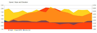
Travel Time: 1:55 (1.44 mph)
Moving Time: 1:34 (1.80 mph)
Elevation Rise: 561'
Maximum Elevation: 6,630'
Start Time: 1:16
Travel Time: 1:49 (1.53 mph)
Moving Time: 1:18 (2.14 mph)
Elevation Rise: 479'
Maximum Elevation: 6,291'
1We actually did not finish the North Boundary trail, but went on a connector trail which is used by the horses. Between the two, I had turned off the GPS. It is about a quarter of a mile which did not get counted in the two sets of
data. It is the dotted area on the map.
Description:1We actually did not finish the North Boundary trail, but went on a connector trail which is used by the horses. Between the two, I had turned off the GPS. It is about a quarter of a mile which did not get counted in the two sets of
 |
| North Grove Loop |
We want to hike and take a look at some of the effects of the Rough Fire. So we are looking at the North Boundary trail to hike while our son is taking care of my Mom. Also we are somewhat scouting out a hike for our Meetup group, to be part of a series called The Destruction Hikes. These hikes will be focused on showing the effects of this large and intense fire. We are expecting somewhat of a short to moderate hike.
 It is a pleasant day, even though we got a later start than a "normal" hiking day. So we get up to Grant Grove for the facilities. While there, I went into the Visitor Center and talked with the information person and explained what I was interested in and what I was going to do. He suggested adding in the North Grove loop as well. So that's what we did.
 |
| Not the General Grant |
It looked like in back of the General Grant there is a trail up to the North Boundary Trail, so we follow it up. But this was probably a social trail because it sort of petered out and we scrambled up to the trail. This is not how we will take the Meetup group-better way is via Gamlin Cabin and the normal connector trail.
The first part of the North Boundary Trail starts going up. We walk by the Sequoia's and marvel at them. How many times have we seen these giants and still are in awe-well maybe the General Grant is the exception. Still appreciate it though. After a ways, we take the leg of the trail up to the stables and look around. To my eye, the Rough Fire did not touch it. But this is not part of our trail, so we backtrack about 150 yards to the junction and head north. So far we see signs of a prescribed fire from a few years ago, but not the big fire.
 |
| Where the prescribed burn stopped the fire |
But then we turn and head back to the south and west and the scene is one of ash. A ravine the trail goes down looks like the fire was pretty intense when it went up it. Makes you appreciate all of these firefighters which stopped the fire before it reached the grove. But surprisingly there are a few bushes which somehow survived the infernal.
 |
| Below is Abbott Creek |
 |
| Sequoia totally burnt. |
We go down and there is more destruction.At the bottom, when the trail makes a left to the south, there is a total lake of green, except at a little bit of water crossing the trail. In a short ways further, there is a Sequoia totally burnt. I thought the these trees were almost immune to that kind of destruction. That tells me how intense this fire was.
 |
| Sequoia Lake Overlook |
 |
| Sherri ending a loop |
It is now time to return back to the car. But we do stop at Bear Mountain Pizza in Squaw Valley. We make it back to Fresno around 5pm.
Background
- The Rough Fire started on July 31, 2016 from a lightening storm. Originally it was called the Garlic Fire because it was misplaced as being on garlic Ridge-the spotting was done in the twilight. It is the 13th largest fire in California's recorded history, burning 151,623 acres with 3,741 firefighters, 345 engines, 19 helicopters and 45 bulldozers used.
- Prescribed burns is used to remove fuels from an area. allowing for more vegetation to grow.
- Wikipedia
- Smokey the Bear
- NPS policy concerning fire.
- Fire is needed for Sequoia seeds to be able to grow.
Extra Photo's
 | ||
|
 |
| Trail Thru Destruction |
 |
| Trail through Destruction |
Animals
 |
| Hoffman Checkerspot |
 |
| Hoffman Checkerspot |
 |
| Hoffman Checkerspot |
 |
| Hoffman Checkerspot |
Flowers and Plants


No comments:
Post a Comment