
Title: January 17, 2018 - Wawona Meadows Extended
Hike Info : Description : Extra Photo's : Animals : Flowers and Plants
Hike Info:
Type: Hiking
Trail: Fish Hatchery, Chowchilla Mtn Road, Mt Savage Road, Connector Trail, Wawona Meadow Trail, Ditch bank
Destination: Loop
 Distance: 7.84 miles
Start Time: 11:04
End Time: 5:20
Travel Time: 6:16 (1.25 mph)
Moving Time: 5:43 (1.37 mph)
Elevation Rise: 1,403' 1
Descent: 1,187‘
Maximum Elevation: 4,875'
1There is a 4024’ difference between the starting and ending elevations. So the 1,187’ elevation descent is probably accurate than the 1,403’ gain. |
| Going down to Big Creek/Merced |
Sherri and I did a variation
of this hike last Fall and really enjoyed it. If we can, we will
cross Big
Creek
and try to find the Wawona
Arboretum.
Rose is coming with us so we meet at her place around 9:00am and take
off from there. We leave shortly after that, stopping at Judy’s
Donuts
in Oakhurst.
On the way in, we recognize
Ranger Corey from walking with him last June around Wawona
Meadow.
He does not think Big Creek is easily crossable right now. We shall
see. We get to the parking lot before 11 and start our walk at 11.
To start with, we cross 41 by
the start of the golf course. Then loop around the end of the course.
Mounds of dirt look like something has been digging (golfers on this
course can get a mole in one). We come to the old smokehouse/the
current golf storage. Then follow a road to Big Creek.
 |
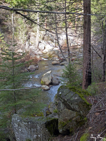
| Confluence of Big Creek and Merced |
We decide to go down to the
fish hatchery first. When we get to the confluence of Big Creek and
the Merced
River.
we look around for a place to cross Big Creek. While it is crossable,
none of us want to get our feet wet. So we looked around the area for
remnants of the fish hatchery--not much too find.
 |
| Balancing log along the Merced |
So we head back up to where we
have seen a unmarked trail go up. This is the same one as Sherri and
I went up a couple of months ago. This trail is is truly a lovely
trail. It just does not go anywhere. When we get to a place which is
maybe 100 yards before the trial stops, we come to a shelf
overlooking Big Creek. After discussing, we decided that this would
be a good place to eat lunch.
 |
| Lunch Spot |
After lunch, we retrace our
steps down this interesting trail, back to the road to Big Creek. We
follow the road back to the golfers barn. Along the way, there is
some interesting moss on rocks. But the thing about these kinds of
scenes is that the eye can take in so much more than a camera lens.
So the pictures appear without the richness we see. Memories are
fragile, but more powerful than fixed images.
 |
| Walking back |
It is time for more history.
We cross over to where Galen Clark's house stood. The problem is, we
are wondering if it is in a different spot than where we thought last
time. Another trip may give us a third location. But the four
Sequoias he planted have not moved, nor has the location of the
fruit trees.
We find a road which the golf
carts uses. Along here, Rose sees the vertebrates of some smaller
animal just laying around. We examine it and then continue on till
we reach the Chowchilla Mtn Road.
 | ||
| Galen Clark's Sequoias |
Question: Do we go easy,
around the regular loop? Or go higher up the slope of
Mt Savage?
Up we go for our real climb of the day. Surprisingly I feel pretty
good going up. I keep up with Sherri and Rose. We get to a split and
follow it up to what I call the Mt
Savage Road.
I think this road must have been an old entry road, but I have not
seen document on this.
 |
| Our deer |
Mt Savage Road crosses across
the mountain, somewhat rising. This is not a route with vistas, just
the quiet beauty of hiking along a forested road without seeing
others. Well almost quiet. Rose and Sherri hear the sound of a coyote
calling. And then again. A third of mile later, three or four deer
come through the trees. Excitement along a quiet trail.
 |
| Gary over a log |
Then there is a little notch
along the side of the road. That is the trail back down to Wawona
Meadows. Another quiet, nondescript trail. The trail is almost all
descending. Few people go down it or even know about it. Nice and
mellow. A good canopy of leaves overhead, mountain misery around our
feet. There are logs we need to go over, a testament to the lack of
use of the trail. We see some power lines which follow our trail.
The the trail weaves its way around a service road until we get to
the bottom and meet up with the loop trail.
Once we get to the loop trail,
I think we are ready to head back to the car. The walk continues
around the far end of the meadow. When the trail approaches the road,
we see the remnants of the flume. I now know what I am seeing. Also
I ask if they would like to go back via a level, but overgrown path.
Sure. So we follow the flume around till we get the the fire road.
From there we descent past the Wawona hotel and down to the lower
parking lot, and too.our car
We head on home as Rose’
husband is preparing her dinner. We get home at 7:30, pretty tire. A
shower revives us before Sherri and I go out to dinner.

Extra Photo's
 |
| Brush in light |
 |
| Rose and Sherri looking over the Merced |
 |
| Big Creek |
 |
| Sherri on Connector Trail |
 |
| The Vista on the Mt Savage Road |
 |
| Almost over |
 |
| Mt Savage |
 |
| Interesting moldy poop |
 |
| Our deer along connector trail |
Flowers and Plants
 |
| Lichen covered tree |
 |
| Mossy Log |
No comments:
Post a Comment