Title: February 1, 2020 - Los Leones Canyon
Hike Info : Description : Extra Photo's : Flowers and Plants
Hike Info:
Type:
Hiking
Trail:
Los Leones Canyon
Destination:
About
5 miles
in
Actual
Destination: About 1.5 miles in
Distance:
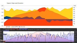
3.16
miles
Start
Time: 2:40
End
Time: 5:50
Moving
Time: 2:04 (1.53
mph)
Elevation
Rise: 902'
Descent: 749‘
Maximum
Elevation: 921'
Description:
 |
| Friday, the Granddog |
I got up at 6:30 and took
Friday, Rachel’s dog out for her morning business. I then went out
for a walk of about 30 minutes. Sherri gets up while I am eating
breakfast. After everything gets done, we put together some plans for
Washington DC. By this time I am ready for lunch. So we do not get
out of Rachel’s apartment until about 1:30.
Rachel has told us about a
five mile trail called Los
Leones
which went up about 1,500’-at least that is what I heard. Sherri
heard a different elevation gain. Anyway, it is about an hour’s
drive to the trailhead in the Santa
Monica Mountains.
We probably take a bit more time.
 |
| Sherri and the entrance gate |
We got started about 2:30
after finding a parking place. I can see that you really need to come
here on the off hours. There is a nice gate leading you to the trail
with a sign over it, but that is all. No sign or anything.
We start up the trail. It is a
single track and a pretty popular trail. Almost from the get go, it
starts to rise. In a short distance, there is a junction with a
mileage sign. The first entry is 1.3 miles to the East Topanga
Fire Road.
We take the trail on the left.
 |
| Los Leones Canyon |
The trail raises up at a
pretty good incline, probably a consistent 10% or more. We are
constantly being passed by those going up. This impresses us by how
out of shape we are, but being passed also gives us mini-breaks to
catch our breath. We do a steady, but slow pace.
 |
| Catalina Island |
As we climb, we start seeing
more of the area of the canyon. Then, the ocean appears. Today is a
clear day. We overhear people saying that this is really unusual as I
am assuming between the ocean mist, fog and smog, the view is more
opaque.
Towards the end of the canyon,
the trail starts to be less of an incline as it cuts across the
ridge. I can still feel the strain in my legs and lungs, but not
much. Our first goal comes into sight: Paseo Miramar Viewpoint. In
about ten minutes more, we are there. This is the 1.3 mile mark, well
short of the 2.5 miles.
 |
| Los Leones Canyon as the sun sets |
The view is splendid. We
examine some cities around us. Some students next to us ask us about
some mountains. With Peak Finder, I look really smart when I name off
Pine Mountain and Mount San Antonio. One person is from UC Santa
Cruz.
After resting here for about
ten minutes and having a Kind bar, we decide to continue on up. But
this resolution only lasts about 15 minutes. We get to a place which
has an even better vista. We go out and enjoy looking at things. Even
more so, we sit down and gaze around. This is as far as we want to
go, so we spend about 20 minutes just relaxing. I could feel the
climb we did, so it would have been very easy to take a nap-I had
found a comfortable place amongst the rocks. Sherri remained
vigilant, or at least enjoying the view from our place.
While we are resting, I text
my family with a picture. This starts off a text storm with almost
all of them. Rachel throws in a few pictures of Capital Reef NP;
David of a birthday party for Kevin. Great to have a family which
will talk with each other.
But the sun was starting to
get low and we have about an hour of getting down the trail to go. So
we start back. The trip down is a lot easier than going up. We stop a
few times for pictures, but not due to catching a breath. Even though
we are moving faster, I am seeing a lot more of the area as we go
down. Maybe because my head is not looking down or a particular
perspective.
When we reach the car, the sky
has turned dark. So we left right at the right time. We go back via
Sunset Blvd and hit 405. We promptly hit traffic there. I ask Sherri,
is she hungry? Yes. We decide on pizza. After wandering around-not
finding one place and another being closed, we find a PizzaRev-sort
of like a Blaze Pizza. We feel good about getting filled with pizza.
A 15 minute trip back to Rachel’s apartment and liberating Friday
and a shower. We feel good about the day.
Extra Photo's
 |
| Los Angeles from Paseo Miramar Viewpoint. |
 |
| Panorama of Los Angeles from Paseo Miramar Viewpoint. |
 |
| Pine Mountain and San Antonio Mountain |
 |
| Panorama from our high point |
 |
| Los Leones Canyon towards the setting sun time |
 |
| Nicolas Island |
Flowers and Plants


No comments:
Post a Comment