
Title: January 11, 2020 - Wawona
Hike Info : Description : Background : Extra Photo's : Flowers and Plants
Hike Info:
Type: Hiking
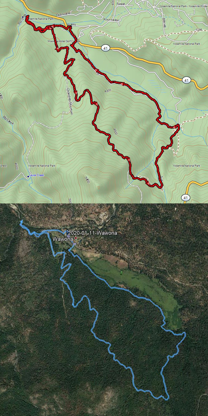
Trail: Wawona Meadow, Raymond Road, Old Trail to Big Creek
Destination: Loop
Distance: 6.97 miles
Start Time: 1:21
End Time: 5:15
Travel Time: 3:53 (1.80 mph)
Moving Time: 3:30 (1.99 mph)
Elevation Rise: 1,246'
Descent: 1,056‘
Maximum Elevation: 4,837'

Description:
I got up this morning not
knowing what we might do or where we might go. Do we stay home and
continue cleaning? Does not sound fun. Is fun the only criteria that
there is? Snowshoe? Snow levels seems to be high, so the
concentration of people will be pretty dense. How about hiking?
Sounds interesting. Where? How about Wawona?
Let's go!
We left Fresno after 11 and
arrived a little before 1 at Wawona. In Oakhurst we changed drivers.
We asked on entry into Yosemite about snow at Mariposa
Grove.
The ranger said there was snow at the Grove, but not lower. Does not
sound too good for hiking. Maybe up to the Grove but not in the
grove. So down to the meadow.
 |
| South Fork of the Merced River |
Before we started hiking, we
ate lunch. That is a peanut butter and Nutella sandwich. Over the
years, we have developed an extended route around Wawona Meadow. Now
to see how much we want to do of it. Actually, we have never done the
extended route all in one hike, just in parts.
 |
| South Fork of the Merced River |
We get our backpacks on and
cross Highway 41. But instead of doing the trail which bi-sects the
golf course, we go on the north end of the course, which takes us by
the golf pro’s shop, which used to be the place where the butcher
did his work for the Wawona Hotel. After rounding the building, we
head towards Big
Creek.
It is a nice, third of mile walk through lots of young trees. We
enjoy the flow of Big Creek as it enters the South
Fork of the Merced River.
Ice has formed in the river, where the flow has not quite knocked it
down. We look around a bit, but do not go over where the pond
was-too much snow and do not want to slip.
We retreat back the way we
came until we come to the old smokehouse. Then we skirt the western
edge of the golf course. Normally we pay a visit to the site of Galen
Clark’s cabin, but it probably is a little bit too mushy, so we
stick to the road which loops over to the Raymond
Road. We
feel that after Pincushion earlier in the week, this road should be
acceptable to us. So up we go. I am doing OK, even though I am glad I
do not have an overnight pack on. The road is pretty firm and we do
not have any problems sliding or anything with it. In places there is
a layer of frost, but nothing bad.
 |
| Sherri on the Mt Savage Road |
We hit the crossover road. I
have speculated that originally this might have been the entrance
road to the park since it comes out right where the guard stations
are. But I have not seen anything which confirms my speculation. By
the way, from what I can find, the road is called the Mt
Savage Road.
Walking is a good way to think
and talk. The most pressing thing we have to think about during the
next several months is what to do about an estate plan. So that is a
topic of discussion. It is obvious we have a difference of opinion on
certain matters, but that is why one talks, to see where you have
agreement and find places where we can agree. We will continue to
talk in the coming days and weeks.
 |
| Gary going back down to Wawona Meadow |
I am looking for a stake and a
trail to go down to Wawona Meadow. I see the stake, but Sherri keeps
going. But not for long. The trail down to Wawona Meadows is narrow,
surrounded by mountain misery for a long ways. Today it has a layer
of snow-not much, but enough to be careful on how one walks. It is a
pleasant route, but the one I am glad we are going down. At one
place, we miss a turn and go down a very steep service road. I know
that it all goes to the same place. Still, it is very steep.
When we reach the trail which
loops around Wawona Meadow, we have a choice-left or right, clockwise
or counter-clockwise? Normally we would go counter-clockwise and
maybe even walk the flume. But it is cold and there are two creeks
which we would need to cross. So we go clock-wise. The walking is
much faster, but the light is fading. We make it back to the car
before dark and even got glimpses of the sun leaving the ridges to
our east.
Now that we are back in the
car, snuggly and warm, the big decision has to be made. Where to eat?
We decide on DiCicco’s
in Oakhurst.
Not a lot to say,except that it was a good choice. Had exactly what
was needed to fill my body. Then it is back to Fresno and a nice hot
shower.

Background
See the Wawona page for some of the things talked about on this page.
Extra Photo's
 |
| Confluence of the Merced River and Big Creek |
 |
| Gary |
 |
| Leaves under snow |
 |
| The road we did not travel |
 |
| South Fork of the Merced River |
 |
| Sherri on the trail down to Wawona |
 |
| Clouds on ridge to the east |
 |
| Sky ablaze |
 |
| Sunlight and clouds |
 |
| More sunlight and clouds |
 |
| Looking towards Mariposa Grove |
Flowers and Plants


No comments:
Post a Comment