Title: May 9, 2021 - Starlight Trail
Hike Info : Description : Extra Photo's : Flowers and Plants
Trail: Starlight Trail, Road 14S14, and Big Meadows Road
Destination: Wander
Distance: 3.66 miles
Start Time: 1:35
End Time: 5:10
Travel Time: 3:35 (1.02 mph)
It is Mother’s Day. Rachel has joined us this week. Most mothers when asked, “what would you like to do on Mothers Day?”, they might say have a nice dinner out, spend time with their kids, maybe take in a show or a movie. When Steven and Rachel asked what Sherri wanted to do, she said she wants to go hiking. That is my woman!
But that does not mean that
Sherri has changed into the crack of dawn person. We do not get off
until a bit before Noon. The drive up is uneventful, as it should
be. The Big
Stump parking
lot does not have many people in it. That is a sign that not many
people made the trek up here for Mother’s Day. We continue on to
where we park at
Big Meadows
to go snowshoeing or cross-country skiing. The actual road to Big
Meadows is open.
Start of our wander
Why park here? There is a Winter Trail which I had suggested we try to walk when it is dry. We are able to follow the blue diamonds of the Starlight Trail. We did a little of this last January. As we follow the diamonds, there is not much of a Summer Trail. But when you are on a wander, even if we lose the diamonds, which we do, that is not much of an issue.

Sherri crossing Woodward Creek 
Rachel and Sherri approaching hill 7704
We did find evidence of an old
dispersed campsite, followed by a dirt road on top of a ridge. When
we get home, I will try to figure out what road this is (looks like
Road 14S30). It looks pretty easy to drive on the part we can see.
And then we continue on, picking up the blue diamonds for a ways. We get to a creek, which I guess is Woodward Creek-the same one which another Winter Trailhead is named after. After that it gets a bit more interesting. We come across a bog turning into a meadow. We get out of that quickly, our steps can be pretty disruptive on a surface like that. (Looking at a map, the Starlight Trail is a bit to the West of our track and further down the creek.)
We had spotted a clear rock
not quite a dome which we have been gradually heading for. After the
meadow, we gain the harder surface of the ridge. It is a quick trip
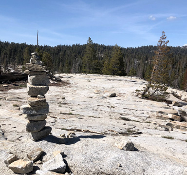
to the top.. Turns out this is marked as 7704 on my topo map. A very
good view from here.
 |
| Buck Rock Lookout |
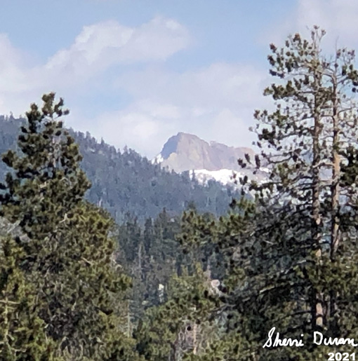
Steven gets out his hammock, stringing it between a couple of trees. The rest of us look around. Montecito-Sequoia Lodge is visible, along with the General’s Highway. Behind that is the ridge which Big Baldy rests on. Looking a bit east of north, I spotted Buck Rock. Then to the south and east of us is Shell Mountain, along with Mt Silliman. Much of the Alta Peak area is visible as well. A really good place to stop.
Evidently none of us felt like traveling further as we either wander around the area, sit down or lie down just to enjoy being here.

Steven and Korra
About 4pm, we decided we had
better head back. But rather than going through the bog, we go a bit
higher up. Here we hit another dispersed campsite and then a road. We
learn this is road 14S14 which is part of the Starlight Trail route.
We head northerly, back towards the Big Meadow Road. Along the way,
we see evidence of burnt slash piles. Looks like the Forest has been
hard at work this Spring.
We hit the Big Meadows Road and start our mile and a half walk down it. Several vehicles pass us by. We see a Forest patrol truck coming up and we recognize it as our friend, Patrol 33. She stops and talks with us for a while. Good to see her. She offers us a ride back to the car-but we do so no. It is not that far, maybe half of a mile from where she stopped. Evidently they just opened up the road today.
We get back to the car a bit
after 5pm. A nice short walk, perfect for a Mother’s Day outing. We
get back to Fresno at 6:40. We have been on the phone for our Sunday
Zoom call. So we transfer over to video once home. From my
perspective, it was an enjoyable Mother’s Day, but then again, I am
not a mother.
Monticeto-Sequoia Lodge
 |
| Gary and Rachel |
 |
| Duck on top of 7704 |
 |
| Big Baldy Ridge |
 |
| Hammock |
 |
| On Top of 7704 |
 |
| Cloud-Cumulus Humilis |
 |
| Mt Silliman |
 |
| Mt Silliman |
 |
| Mt SIlliman |
 |
| Well Shaped Tree |
 |
| Family: Gary, Sherri, Kora, Steven and Rachel |
 |
| Strocumulous over Shell Mountain |
Flowers and Plants
 |
| Possibly an emerging Corn Lily |
 |
| Phlox |


No comments:
Post a Comment