Thursday, May 19, 2016

May 19, 2016 - Ft Monroe


Title: May 19, 2016 - Ft Monroe
Hike Info : Description :  Background : Extra Photo's : Flowers and Plants

Trail head: Bridalveil Falls Road
Hike Info:
Type:  Hiking
Trail: Old Wawona Road
Destination: Ft Monroe, maybe beyond
Actual Destination: Ft Monroe
Distance: 6.91 miles
Start Time:  10:19
End Time:     2:09
Travel Time: 3:49 (1.81 mph)
Moving Time: 3:16 (2.12 mph)
Elevation Rise: 1,760'
Maximum Elevation: 5,581'


Description:
Sherri and Steven want to bike ride around Yosemite Valley, so this gives me about three hours to go hiking and wandering. The biggest challenge is where? What am I in shape for? What is of interest to me? What is the meaning of life? Oops, not the last. So after doing a fair amount of pondering, I decide to walk the Old Wawona Road to Ft Monroe. With a little bit of effort, I might be able to go beyond where Ft Monroe is and explore a bit. But this might be optimistic.

We leave Fresno around 7:45. I need to stop at Kaiser to pick up a prescription. While I am doing that, Sherri and Steven pick up gas for the car at Costco. Then it is off to Yosemite and adventure. We get to Bridalveil after a brief stop at Chinquapin for their bathrooms. Instead of parking in the Bridalveil Falls Parking Lot, we have to park along the road a couple hundred yards away. By the time I start walking, it is 10:15.
Beginning of Old Road

Downed Trees
I walk the pavement past the parking lot and up another quarter mile to the start of the old road.This road is partially paved, but is a wonderful hike. It starts to climb and as the politicians might say, Can I feel the burn? While the rise is not steep, it is steady. There are many downed trees-more than what I had seen last year. A wet Winter, maybe, or just an aging, un-maintained trail finally start deteriorated to this point? But I enjoy going places where others do not go. So I continue going up the trail, or should I say road.

Ribbon Falls
There are two running creeks in place of of the dry ravines I have seen before-except when I had a hike in a pouring rain. The first creek is Meadow Brook, which above me Silver Strand Falls is created from. No wonder Silver Strand is only a seasonal falls. After that is Artist Creek. I know at that point, I am getting close to my first point: Artist Point. This is one of the finest view of the Valley, except for one.

View from Artist Point


After properly gawking here and trying to find the benchmark-which I don't see, I continue my walking. On the way up, I see a couple looking for Artist Point and I point the way and continue on with mine. Instead of going directly up to New Inspiration Point, I continue on the more gentler route with the road. It goes up and gives a good, but not the greatest, view of the Cascade Falls area. After that, and a few more trees to go over and around before I hit Inspiration Point.

Cascade Falls From Ft Monroe
But my goal is not Inspiration Point, but at least making it to Ft Monroe, and hopefully beyond. At Inspiration Point, I see a few people, but do not stop or even say hello as they are a ways away and I want to get on.  More uphill, but not bad. The times I have walked up here, it has been dry. Today, various places of the old road is a bit mushy. Previously, I had seen this old pipe laying on the side of the road, somewhat buried and could not figure out why. Today I see a bit more as water is draining from a small pool behind it. I suspect that at times, this could have been a water supply for someone.
Old Pipe


Cascade Falls
I finally get to Ft Monroe, which if you have read my other blog entries you know that it never was a fort, but a stagecoach stop named after George Monroe, a black stagecoach driver. I realize that I am little bit beyond my turn around time, but I need to have lunch. I spot a place about a hundred yards off the road which looks like it has a good view, and that is where I eat. This is a good place as you can see down the Merced River and across to the Cascade Creek area. Nice and peaceful view.

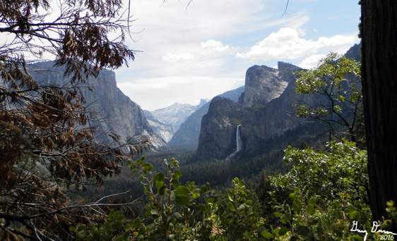
Yosemite Valley from Inspiration Point


But now it is time to return. The first bit is down the road I just came up. But then it is downhill, sol I make good time. I stop at Inspiration Point to get the "standard" photo from there. The view is good and Yosemite looks fabulous. Also Bridalveil is good looking. One can stay up here forever with a mouth open, gaping at this. But I need to go on.

Bridalveil Falls from Inspiration Point


Why you might ask? First, because Sherri and Steven will be waiting for me at the parking lot. But also because there is another view which I like a lot better. I call it "Gary's Point". But I know I am  not the first to find it, only one of many who has come across it because there is a path to it, away from the Pohono Trail-which ends at Tunnel View. I found this view a few years ago when I was walking this trail with a few other people and came across the path. I took it to see where it went and saw the best view of the Valley. As a bonus, the path points straight to Silver Strand Falls

Yosemite Valley from "Gary's Point"
Silver Strand and path to Gary's Point


Trees across road
But now, I get walking again and meet a couple who I judge to be a bit older than-hard to believe isn't it? They are backpacking and going to go up to Ostrander Lake. They start at Tunnel View and are doing the climb up-this is a 3,000' ascent. We exchange notes about things and tell them there is a good camp spot at Bridalveil Creek. They are relieved by that. Now I head the two miles back down the Old Wawona Road, stopping to gawk once again at Artist Point. I cross the many fallen logs I encountered when I came up it.

I get to the car without incident around 2:10. Sherri and Steven have been waiting for me for about half an hour. They had made two loops around the Valley floor and enjoyed their time. So off we go to Oakhurst and the Southgate Brewery before heading home.


Background
See my write up on Artist Point, Ft Monroe and the Old Wawona Road for more information on these items.

Extra Photo's

Yosemite Valley


Ribbon Falls and El Capitan

Cascade Falls and the Devils Dance Floor


Afternoon shot of the Valley from Artist Point

Flowers and Plants


Puffball Fungi

Phlox


Sunday, May 15, 2016

May 15, 2016 - Return from Alder Creek

Title: May 15, 2016 - Return from Alder Creek
Hike Info : Description :  Menu :  Flowers and Plants

Trail head: Camp at Trail Jct at Alder Creek
Hike Info:
Type:  Backpacking
Trail: Alder Creek Trail
Destination:Trail head at Mosquito Creek
Distance:   4.99 miles 1
Start Time:  9:15am
End Time:  12:30pm
Elevation Rise:   231'  1
Maximum Elevation: 6,012' 1

 1Information here is based upon the time going in since I could not find my GPS.
Description:
I slept a bit cold, but not too cold. Lesson to Gary: if you think it will be cold and you are packing a light-weight sleeping bag, be sure your sleeping bag insert is also packed. Enough said on that. I had woken up at 5:54am, by my cell phone time, then rolled over and went back to sleep. When I woke up a half an hour later, Rachel was already climbing out of the tent. This is a new experience for me, being the last one up. I can sort of enjoy it on occasion. But what that says is that I did not get the opportunity to have my quiet time or enjoy a few minutes of solitude. But I was able to enjoy being with my daughter-even better.

Rachel goes back in the bag
We seem to be doing ok in the getting packed up and ready to go department, but when I look at the time it is 9am, about the time I was hoping to leave by-not that we had to leave by then. But this way, it gives my daughter a chance to get back to her place reasonably rested. But now some excitement. Where is my GPS? I had it last night and put it away in my pack. I thought I put it in the lid area, but I cannot find it. We make a good sweep of the area, removing a little bit of litter-not much as it is clean.  Still no GPS.That leaves me with the choice of unpacking my pack or assume it is in the pack someplace as it is no place else. I go with the assumption. We shall see if I guessed right.

Avoiding a creek crossing
Rachel does not want to do the barefoot walk across Alder Creek like we did yesterday. So we stay on the south side of the creek, without a trail. You can tell others have been this way, including Sherri and I several years ago. But then, it was not a savings of time or effort and since that time we have just endured crossing the creek. Rachel is a bit more agile and quicker than her mother so we get around the 3/8 mile area without any trouble, just a bit of climbing.

Once we hit the trail, we make some pretty good speed, even crossing the little creek we did yesterday on some thin logs. That is when I dismounted, I hit a boggish place and sink about 2 inches into some yuckish stuff.

Alder Creek Falls


We come to Alder Creek Falls and rest for  a few minutes while we enjoy a final viewing of the Falls. They are amazing and we have them all too ourselves today. But then we continue on the old railroad bed at a pretty good pace. Towards the end of the bed I can feel that I am not used to the added weight of my boots on my feet. Something I had better get used to.

Coming down from the railroad bed I am now on sandal watch. You know the sandal which dropped off of my pack yesterday. We travel at a good pace-we should since it is 75% downhill. But the boots feel heavy on my feet, so the legs are starting to get a bit sore.

We meet a couple of females where we had a nice little conversation. One of the people is a member of the Central Valley Hiking Group, which is the group I often walk with, and even organize some hikes with. After we finish talking with them, another female comes up and says hi and passes on up the trail. From there it is just continue walking down a trail I have been down several times until we get to the truck.

Sandal Found
But you know the sandal I lost? The CCC people from Greenwood had put it into the back of my truck. Yeah for them! So we through our packs in back and head on to Oakhurst to enjoy an afternoon meal.

We tried going to Southgate Brewery, but the parking lot was full and so we decided to try DiCicco's which we like in Fresno. Here in Oakhurst, it appears that sometimes it is understaffed. But the waitress did not help their cause when she said that she would take our drink order, but would not take our order because she needed to take other people's order first. We convinced her to take ours now and then just put it into the right order. It seemed like the service took forever, like it took about an hour and half to leave the resturant after we arrived. Most of the time, that is ok, but we were ready for home and when we got home, it was nice getting into the shower.

It was really good going out with Rachel. So glad I was able to go with her.


Menu
 Breakfast Lunch Dinner Snacks
Oatmeal and add-ins, such as dried strawberries. We also had dehydrated Peanut Butter mixed in Ate at DiCicco's in Oakhurst Home Clif Bar, Jelly Bellies


Flowers and Plants


Dog Vomit Slime Mold

Hartweig Iris


Saturday, May 14, 2016

May 14, 2016 - Alder Creek

Title: May 14, 2016 - Alder Creek
Hike Info : Description :  Menu :  Flowers and Plants
Trail head: Mosquito Creek

Hike Info:
Type:  Backpacking
Trail: Alder Creek
Destination: Trail Junction at Alder Creek and the Deer Camp Trail
Distance: 4.99 miles
Start Time:  11:15
End Time:     3:41
Travel Time: 4:25 (1.13 mph)
Moving Time: 2:36 (1.92 mph)
Elevation Rise: 1,467'
Maximum Elevation: 6,012'


Description:

There is something special when your daughter asks you if you want to go backpacking with her. That is what happened in April. So we figured out a weekend and then worked on what place to go into. We talked about Paradise Valley in Kings Canyon or the High Sierra Trail-just an in and out for the weekend. But none of these felt right. Sherri and I love doing Alder Creek each Spring, so this seemed like a good place, particularly since Rachel had not been there before. (For the record, I have two daughters and one son, and whenever any of them talk about going up to the Sierra's with me, I am a happy camper-literally.)

Rachel came up Friday night and we got our act together that evening about what to take. I want to carry most things since I am training for the JMT and this is the first backpacking of the season for me. Alder Creek is not a long hike, so I knew we did not need to get an early start.  On the way up to Yosemite, we stopped in Oakhurst and got the traditional sandwich-both for lunch and dinner. I got a turkey sandwich from Pete's Place. Then off to Yosemite-excitement! That is until we got into a 45 minute line to enter into Yosemite. What a wait! But we got in and headed over to Wawona and the Wilderness Office where Ranger Dave issued our permit.

Rachel going through the ghost forest
By the time we got to Mosquito Creek, our trailhead, it was starting to get warm, There were also several official looking vehicles parked there. So we just lined ours up and started hiking around 11:15.This a trail I know well. The first 3/4 of a mile is a pretty good haul up. When I walked it at the start of April, the buck brush was over-growing the trail. But today, it had been very nicely trimmed back, about 2 yards away from the trail. The trees are now part of a ghost forest from a prescribed burn about 8 years ago. It is nice walking. Just a good haul up. Rachel does not seem to be too taken back with the climb up. I on the other hand is sweating a bit and huffing and puffing.

Alder Falls

Once we got to the Wawona junction, the trail leveled out some. But as we walked along, I could feel that my legs were not used to wearing boots-this was the first time with boots this year, as well as the first over-nighter this season. Someplace in this section, my loving daughter provides motivation to get the job done. How, you might ask? Well the story goes like this. Since I am preparing for the JMT, I thought I would carry a load to prepare me for it. Things like the tent, food, JetBoil, ... Rachel's loving comment was. if you need to take some weight off, ... So what kind of response do you think that elicited? A sneer and determination to get the job done.

Top of the Falls
Somehow, being older, the motivation gave out after a mile or so. So we took a Clif Bar break.  Evidently at this point, one of my sandals dropped off my pack. Why didn't the pack feel lighter then?  But it wasn't until we reach the old railroad bed before I noticed it. I thought, Oh Well, it should be there when we go back down this trail tomorrow.

Coiled Cable Snake
The good part of the old Yosemite Lumber Railroad/Sugar Pine Railroad is the the trail is nearly flat. Even with my decreasing stamina, we made some pretty good time. I do need to warn Rachel about the dangers of cable snakes, particularly if they are coiled. When we round the corner, the Falls are there in full flow. It is a sight which does not fail to take my breath away. I thought we would be the only ones here, but the CCC crew is working close to the falls. So we stop and have lunch from my viewpoint.

Tail Crew from Greenwood CCC
Lunch is the turkey sandwich I got from Pete's Place this morning. Just a pile of turkey and bread, with a ton of mayo. Tastes real good about now. After looking and relaxing with the falls, time to head on. Rachel experiences the trail hazard of walking with me: I stop and talk with people. This time it is with the Trail Crew. I always thank them for working on the trail I am walking on. In conversation with them, they say they are from Greenwood, up near Auburn. They are around Yosemite for eight weeks, and then back at the camp for eight weeks. I tell them about my lost sandal.  The women I am talking with says that she will keep an eye out for it.

Crossing our tiny creek
We walk on. While the trail is not as level as the last mile along the railroad bed, we do continue to follow remanents of the bed for a ways. One question which keeps popping into my mind, where did the railroad cross Alder Creek? I have several thoughts, but nothing definitive. Maybe one of these days I will find some of the older maps and be able to tell.

After a ways, we cross a tiny creek. But the flow is enough that we use a log to help us across. Much more fun anyway than rock hopping across. I do my semi-wabble across; Rachel is a bit more cautious. We continue on and any semblance of a railroad is lost and a real trail takes us up the creek. Having boots on instead of trail runner shoes continue to take a toll on me. But I am still going ok. Just slowing down. But there is a section where the trail crosses Alder Creek. nothing dangerous, just need to take off our shoes for this crossing. I know what to expect: cold water. I cross with my one sandal which feels better than bare feet-still is cold, but the rocks do not hurt as much. Rachel, on the other hand does not have any clue on how cold it is. So her first step into the water is an exercise in eye and mouth opening. She is a bit more sensitive to the cold than I am. But we get across.

Alder Creek Crossing
After resting a few minutes from the trauma of the crossing, we continue on. I do not have the heart to tell her that we will be crossing the creek again in 5 minutes. Which we do. But this time it is on logs. Our campsite is just across the creek-Sherri and I have camped here many a time.

Hot Chocolate
Camp gets set up and dinner is eaten-same as lunch. One of those nice secrets we have learned: a sandwich is usually too much for lunch but can be split between lunch and dinner for a satisfactory meal. We then go on a two mile hike, round trip, towards Deer Camp. Even spot a patch of snow-just a small patch. When we hit a creek about a quarter mile before Deer Camp, we decide we have had enough creek crossings for the day. Back at camp, it is time to retire to our sleeping bags, and then a "special" showing of The Martian. The specialness is being able to see it out here with my daughter, on a Samsung Galaxy phone-talking about a small screen. With that we fall asleep.


Menu
 Breakfast Lunch Dinner Snacks
At Home Turkey sandwich from Pete's Place in Oakhurst Turkey sandwich from Pete's Place in Oakhurst Clif Bar, Jelly Bellies


Flowers and Plants
Snow Plants

Dog Vomit Slime Mold


Wednesday, May 11, 2016

May 11, 2016 - North Boundary, North Grove and Dead Giant Loop Trails


Title: May 11, 2016 - North Boundary, North Grove and Dead Giant Loop Trails
Hike Info : Description : Background : Extra Photo's : Animals : Flowers and Plants
Trail head: General Grant Tree Parking Lot


Hike Info:
Type:  Hiking
Trail: North Boundary, North Grove and Dead Giant Loops
Destination:North Boundary Loop
Distance: 2.83 miles
Start Time:  10:52
End Time:    12:47
Travel Time:  1:55 (1.44 mph)
Moving Time: 1:34 (1.80 mph)
Elevation Rise: 561'
Maximum Elevation: 6,630'


Destination:North Grove and Dead Giant Loop
Distance:   2.78 miles 1
Start Time:  1:16
North Boundary Loop
End Time:    3:05
Travel Time: 1:49 (1.53 mph)
Moving Time: 1:18 (2.14 mph)
Elevation Rise: 479'
Maximum Elevation: 6,291'
  1We actually did not finish the North Boundary trail, but went on a connector trail which is used by the horses. Between the two, I had turned off the GPS. It is about a quarter of a mile which did not get counted in the two sets of
North Grove Loop
data. It is the dotted area on the map.


Description:
We want to hike and take a look at some of the effects of the Rough Fire. So we are looking at the North Boundary trail to hike while our son is taking care of my Mom. Also we are somewhat scouting out a hike for our Meetup group, to be part of a series called  The Destruction Hikes. These hikes will be focused on showing the effects of this large and intense fire. We are expecting somewhat of a short to moderate hike.

It is a pleasant day, even though we got a later start than a "normal" hiking day. So we get up to Grant Grove for the facilities. While there, I went into the Visitor Center and talked with the information person and explained what I was interested in and what I was going to do. He suggested adding in the North Grove loop as well. So that's what we did.

Not the General Grant
We started out by going up the trail out of the General Grant Parking Lot, up towards the  Visitor Center, but we go up a couple hundred yards up a little used trail. But there is a cut off over to the General Grant Tree. We have been here so many times, this tree is just part of the backdrop to us. But then again, what a backdrop. So many big trees and this is the king of the area.


It looked like in back of the General Grant there is a trail up to the North Boundary Trail, so we follow it up. But this was probably a social trail because it sort of petered out and we scrambled up to the trail. This is not how we will take the Meetup group-better way is via Gamlin Cabin and the normal connector trail.

The first part of the North Boundary Trail starts going up. We walk by the Sequoia's and marvel at them. How many times have we seen these giants and still are in awe-well maybe the General Grant is the exception. Still appreciate it though. After a ways, we take the leg of the trail up to the stables and look around. To my eye, the Rough Fire did not touch it. But this is not part of our trail, so we backtrack about 150 yards to the junction and head north. So far we see signs of a prescribed fire from a few years ago, but not the big fire.

Where the prescribed burn stopped the fire
But that changes once we top a ridge. This is where the firefighters made one of their stands and where the prescribed burn stopped the fire by depriving it of fuel. Still the north side of the ridge is scorched, but not devastated. We marvel at the scene and continue to walk.

But then we turn and head back to the south and west and the scene is one of ash. A ravine the trail goes down looks like the fire was pretty intense when it went up it. Makes you appreciate all of these firefighters which stopped the fire before it reached the grove. But surprisingly there are a few bushes which somehow survived the infernal.

Below is Abbott Creek
There was a few glimpses into Abbott Creek drainage where you could see the vastness of the fire. We continue around the towards the Grove area seeing the remains of the fire until we hit a rise looking down on the parking lot. Here we see a little connector trail-actually, it is the trail the horses use to the North Grove. We stop at the top and rest and eat for a little while. Not a great view point, still it is away from all of the people by Grant Grove.

Sequoia totally burnt.
Using the connector trail, we hit the North Grove Loop, just above where the loop comes back together again. We take the steeper, north side trail. That is steeper down. But it contains some of my favorite parts of this trail. There are a couple young Sequoia;s guarding the trail, or should I say road, as this loop used to be a road and drivable.  But when we get there, we can tell how far the Rough Fire moved through this area, right to the edge of these trees. Along the ridge above, the area is a combination of black burnt trees with the whiteness of ash on the ground.  This is an area which felt the brunt of the fire.

We go down and there is more destruction.At the bottom, when the trail makes a left to the south, there is a total lake of green, except at a little bit of water crossing the trail. In a short ways further, there is a Sequoia totally burnt. I thought the these trees were almost immune to that kind of destruction. That tells me how intense this fire was.

Sequoia Lake Overlook
Sherri ending a loop
A little ways beyond this we decide to hike over to the Dead Giant. The Dead Giant died many years ago and was not a victim of the Rough Fire. We proceed on this short loop, almost oblivious to where the fire was, until we come to the Sequoia Lake overlook. The Lake looks no worse for the fire, even though I know it came close, very close.

It is now time to return back to the car. But we do stop at Bear Mountain Pizza in Squaw Valley. We make it back to Fresno around 5pm.


Background
  • The Rough Fire started on July 31, 2016 from a lightening storm. Originally it was called the Garlic Fire because it was misplaced as being on garlic Ridge-the spotting was done in the twilight. It is the 13th largest fire in California's recorded history, burning 151,623 acres with 3,741 firefighters, 345 engines, 19 helicopters and 45 bulldozers used.
  • Prescribed burns is used to remove fuels from an area. allowing for more vegetation to grow.
  • Fire is needed for Sequoia seeds to be able to grow.

Extra Photo's

North Boundary Trail with Sherri
Trail Through Destruction
Trail Thru Destruction


Trail through Destruction


Animals
Hoffman Checkerspot

Hoffman Checkerspot

Hoffman Checkerspot

Hoffman Checkerspot

Flowers and Plants